JSmith
Banned
So relations between the West and the Soviet Union are better during and post WW2 . So instead of Germany looking like this post WW2
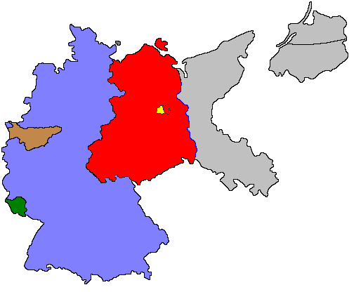
Political borders of post-World War II Germany (1949). West Germany is shown in Blue, East Germany is shown in Red, The Saar protectorate under French economic control is shown in Green. The Ruhr Area, the industrial engine of West Germany, is shown in brown as it was under the control of the International Authority for the Ruhr. Pre-war German territory east of the Oder-Neisse line is shown in Gray, as it was assigned/annexed to Poland and the Soviet Union. West Berlin is shown in Yellow as it was formally under occupation by the Allies until 1990.
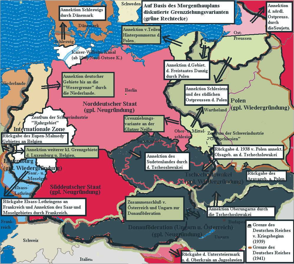
The Morgenthau Plan http://en.wikipedia.org/wiki/Morgenthau_Plan or something like it is instituted and Germany looks like this

The (1944) U.S. "Morgenthau Plan" showing the planned partitioning of Germany into a North State, a South State, and an International zone. Areas in grey are areas intended for annexation by France, Poland and the U.S.S.R. (Today Russia).
The background template used for this image was the following fre license image: File:GermanyMorgenthau.PNG
The Modification of the map, in order to portray the dismemberment of Germany as envisioned by the U.S.A. government under the name of the "Morgenthau Plan", was done by as closely as possible following the borders shown on the following two maps.
http://www.fdrlibrary.marist.edu/psf/box31/a297a09.html http://zis.uibk.ac.at:81/zisneu/dokumente/karten/2.php Both show in effect the same, but the second has workable scanning resolution.
Stor stark7 23:18, 24 February 2006 (UTC)
The text corresponding to the map is as follows: http://www.fdrlibrary.marist.edu/psf/box31/t297a01.html
2. Partitioning of Germany.
(a) Poland should get that part of East Prussia which doesn't go to the U.S.S.R. and the southern portion of Silesia as indicated on the attached map, (Appendix A).
(b) France should get the Saar and the adjacent territories bounded by the Rhine and the Moselle Rivers.
(c) As indicated in part 3 an International zone should be created containing the Ruhr and the surrounding industrial areas.
(d) The remaining portion of Germany should be divided into two autonomous, independent states, (1) a South German state comprising Bavaria, Wuerttemberg, Baden and some smaller areas and (2) a North German state comprising a large part of the old state of Prussia, Saxony, Thuringia and several smaller states.
There shall be a custom union between the new South German state and Austria, which will be restored to her pre-1938 political borders.
3. The Ruhr Area. (The Ruhr, surrounding industrial areas, as shown on the attached map, including the Rhineland, the Kiel Canal, and all German territory north of the Kiel Canal.)
Here lies the heart of German industrial power, the cauldron of wars. This area should not only be stripped of all presently existing industries but so weakened and controlled that it can not in the fore- seeable future become an industrial area. The following steps will accomplish this:
(a) Within a short period, if possible not longer than 6 months after the cessation of hostilities, all industrial plants and equipment not destroyed by military action shall either be completely dismantled and removed from the area or completely destroyed. All equipment shall be removed from the mines and the mines shall be thoroughly wrecked.
It is anticipated that the stripping of this area would be accomplished in three stages:
(i) The military forces immediately upon entry into the area shal destroy all plants and equipment which cannot be removed.
(ii) Removal of plants and equipment by members of the United Nations as restitution and reparation (Paragraph 4).
(iii) All plants and equipment not removed within a stated period of time, say 6 months, will be completely destroyed or reduced to scrap and allocated to the United Nations.
(b) All people within the area should be made to understand that this area will not again be allowed to become an industrial area. Accordingly, all people and their families within the area having special skills or technical training should be encouraged to migrate permanently from the area and should be as widely dispersed as possible.
(c) The area should be made an international zone to be governed by an international security organization to be established by the United Nations. In governing the area the international organization should be guided by policies designed to further the above stated objectives.
or this

Other discussed partition plan proposals (variant North German State, South German State and large Danube Federation (Austria, Hungary and Czechoslovakia) plus annexation of German border areas by the Netherlands (Dutch annexation of German territory after World War II), Denmark(Schleswig), Poland, USSR, Luxembourg, Belgium and France)
What happens when Soviet/West relations go sour or what happens if they stay good?
Political borders of post-World War II Germany (1949). West Germany is shown in Blue, East Germany is shown in Red, The Saar protectorate under French economic control is shown in Green. The Ruhr Area, the industrial engine of West Germany, is shown in brown as it was under the control of the International Authority for the Ruhr. Pre-war German territory east of the Oder-Neisse line is shown in Gray, as it was assigned/annexed to Poland and the Soviet Union. West Berlin is shown in Yellow as it was formally under occupation by the Allies until 1990.
The Morgenthau Plan http://en.wikipedia.org/wiki/Morgenthau_Plan or something like it is instituted and Germany looks like this

The (1944) U.S. "Morgenthau Plan" showing the planned partitioning of Germany into a North State, a South State, and an International zone. Areas in grey are areas intended for annexation by France, Poland and the U.S.S.R. (Today Russia).
The background template used for this image was the following fre license image: File:GermanyMorgenthau.PNG
The Modification of the map, in order to portray the dismemberment of Germany as envisioned by the U.S.A. government under the name of the "Morgenthau Plan", was done by as closely as possible following the borders shown on the following two maps.
http://www.fdrlibrary.marist.edu/psf/box31/a297a09.html http://zis.uibk.ac.at:81/zisneu/dokumente/karten/2.php Both show in effect the same, but the second has workable scanning resolution.
Stor stark7 23:18, 24 February 2006 (UTC)
The text corresponding to the map is as follows: http://www.fdrlibrary.marist.edu/psf/box31/t297a01.html
2. Partitioning of Germany.
(a) Poland should get that part of East Prussia which doesn't go to the U.S.S.R. and the southern portion of Silesia as indicated on the attached map, (Appendix A).
(b) France should get the Saar and the adjacent territories bounded by the Rhine and the Moselle Rivers.
(c) As indicated in part 3 an International zone should be created containing the Ruhr and the surrounding industrial areas.
(d) The remaining portion of Germany should be divided into two autonomous, independent states, (1) a South German state comprising Bavaria, Wuerttemberg, Baden and some smaller areas and (2) a North German state comprising a large part of the old state of Prussia, Saxony, Thuringia and several smaller states.
There shall be a custom union between the new South German state and Austria, which will be restored to her pre-1938 political borders.
3. The Ruhr Area. (The Ruhr, surrounding industrial areas, as shown on the attached map, including the Rhineland, the Kiel Canal, and all German territory north of the Kiel Canal.)
Here lies the heart of German industrial power, the cauldron of wars. This area should not only be stripped of all presently existing industries but so weakened and controlled that it can not in the fore- seeable future become an industrial area. The following steps will accomplish this:
(a) Within a short period, if possible not longer than 6 months after the cessation of hostilities, all industrial plants and equipment not destroyed by military action shall either be completely dismantled and removed from the area or completely destroyed. All equipment shall be removed from the mines and the mines shall be thoroughly wrecked.
It is anticipated that the stripping of this area would be accomplished in three stages:
(i) The military forces immediately upon entry into the area shal destroy all plants and equipment which cannot be removed.
(ii) Removal of plants and equipment by members of the United Nations as restitution and reparation (Paragraph 4).
(iii) All plants and equipment not removed within a stated period of time, say 6 months, will be completely destroyed or reduced to scrap and allocated to the United Nations.
(b) All people within the area should be made to understand that this area will not again be allowed to become an industrial area. Accordingly, all people and their families within the area having special skills or technical training should be encouraged to migrate permanently from the area and should be as widely dispersed as possible.
(c) The area should be made an international zone to be governed by an international security organization to be established by the United Nations. In governing the area the international organization should be guided by policies designed to further the above stated objectives.
or this
Other discussed partition plan proposals (variant North German State, South German State and large Danube Federation (Austria, Hungary and Czechoslovakia) plus annexation of German border areas by the Netherlands (Dutch annexation of German territory after World War II), Denmark(Schleswig), Poland, USSR, Luxembourg, Belgium and France)
What happens when Soviet/West relations go sour or what happens if they stay good?
Last edited: