Bytor
Monthly Donor
That will depend heavily on what software you are using for drawing. Inkscape makes it easy with fill patterns.How do you do vertical and horizontal stripes of equal width on maps?
That will depend heavily on what software you are using for drawing. Inkscape makes it easy with fill patterns.How do you do vertical and horizontal stripes of equal width on maps?
I don;t get it on Chrome on Ubuntu.Another reason to ditch Chrome (and other Chromium browsers)...
While we're on the topic, how do you pick a color for the stripes? IIRC, not being able to figure out is why this map is in black andThat will depend heavily on what software you are using for drawing. Inkscape makes it easy with fill patterns.
I'm on Chrome on Windows and I don't get it either.Another reason to ditch Chrome (and other Chromium browsers)...
I still like looking back through them sometimes, even if most of them are of dubious plausibility and a couple are actually offensive to me.alternate history travel guides
The similar colours make me keep thinking it's a Spanish Empire.Mongols succeed in conquering Japan
Like so?Naturally Christians immigrated as well but in New Zealand (not shown on this map) natural paganism is still a plurality.
Yeah, something like that! If I was doing the whole world, though, I'd chuck in the North American ex-colonies, African and Asian ex-colonies, and so on, but I just threw the map together for a bit of a laugh.I still like looking back through them sometimes, even if most of them are of dubious plausibility and a couple are actually offensive to me.
I was actually working on a cover of the "Puritan" one but it was lost when my old computer was stolen. (Don't leave expensive stuff unsupervised, even in front of security cameras)
The similar colours make me keep thinking it's a Spanish Empire.
Like so?
The similar colours make me keep thinking it's a Spanish Empire.
Better yet, one where Spain is ruled by a Mongol dynasty.I'll have to do a "Mongol vs Spanish empire" map one day to screw with people with cheap computer displays and the color blind.
Whilst Mongolia is, somehow, ruled by a Spanish dynasty.Better yet, one where Spain is ruled by a Mongol dynasty.
Now I wonder, does the Horde take the Caliphate route by going Egypt > North Africa > Iberia, or does it sweep through western Europe?Better yet, one where Spain is ruled by a Mongol dynasty.
This makes me think what are the best routes for imperial expansionNow I wonder, does the Horde take the Caliphate route by going Egypt > North Africa > Iberia, or does it sweep through western Europe?
Following this up because I really should've just finished the lore instead of getting lazy: The background for Southeast Asia in Giant Canada World.snip
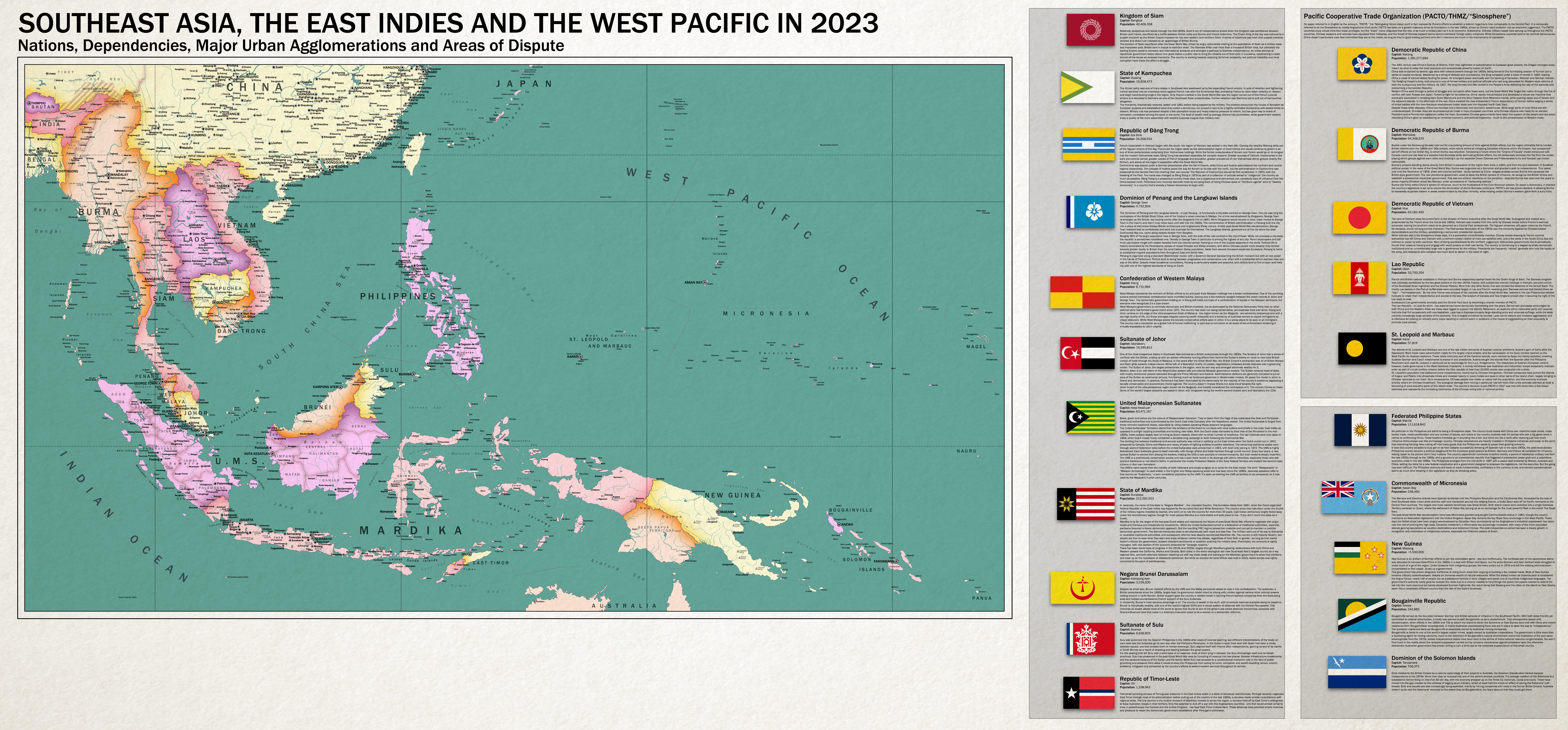
Penang's lore says that it has Governor-General representing the British monarch but it is labelled as a republic. What's going on there?Following this up because I really should've just finished the lore instead of getting lazy: The background for Southeast Asia in Giant Canada World.

China is obviously the big surly boy in this region.
Brain fart. Should be a Dominion.Penang's lore says that it has Governor-General representing the British monarch but it is labelled as a republic. What's going on there?
Before you Download

Data Shield for Chrome™
Click continue to go to the Chrome Web Store and install our Chrome Extension. This extension modifies your default search provider to use our custom safe web search, blocks dangerous pages, and protects your searches.
Seriously, what is this? I was trying to get paint.net and it's insisting on my first downloading something else which will mess with my settings. That does not bring me any joy.
View attachment 874189
View attachment 874190
Someone asked me by PM if they could use the elevations on my map to create their own. This made me think he might not be the only one, so I went ahead and made a blank map version of it.
You'll sadly have to assemble it on your own since the file is too big for me to post in one go. The whole map is 8192x4096 in total, and I've divided into two 4096x4096 halves to make it easier to assemble the blank map.
Anyway, feel free to use it.
EDIT: Just one thing. If you can, try not to copy the original map I posted a few pages ago. Make your own work, it'll be more unique.
Thanks. I don't know if I will make a map myself, but I love this alternate geography map.View attachment 874189
View attachment 874190
Someone asked me by PM if they could use the elevations on my map to create their own. This made me think he might not be the only one, so I went ahead and made a blank map version of it.
You'll sadly have to assemble it on your own since the file is too big for me to post in one go. The whole map is 8192x4096 in total, and I've divided into two 4096x4096 halves to make it easier to assemble the blank map.
Anyway, feel free to use it.
EDIT: Just one thing. If you can, try not to copy the original map I posted a few pages ago. Make your own work, it'll be more unique.