Map Thread XIX

Status
Not open for further replies.
Glad you appreciated the Woody Allen bit - thought it might be a little dark for this forum...


All absolutely fantastic ideas, and I strongly suspect that when the Bronx zone gets up and running properly something along the lines of your suggestion will be implemented. I'm afraid I still haven't got a clue what'd go in the Queens zone: do any actual New Yorkers have a strong opinion on it?
Most of the New York stereotypes I've seen treat Queens as West Long Island or East New Jersey, albeit more multicultural: a land of white-picket-fence suburbia that somehow got caught within New York's borders. There, you'd probably have the Fran Fine and Archie Bunker Experiences, next to the World's Fair Zone around a mocked-up Flushing Meadows-Corona Park where they serve "authentic international cuisine".

Oh, and guidoes.

This is also just the typical pop culture depiction of State Island, except maybe slightly less depressing.
 
The fun thing about the French occupied part is I just thought for 30 seconds, "What would Napoleon III do" and then it'd be rushing in to take Louisiana in a weird appeal to nationalism and imperial revanchism and freedom and something. My initial thought of what to do (not set in stone) would be a wacky French overseas region where the French would dump a ton of Algerians like they did in New Caledonia and allow medium sized firms to invest there sorta like with Algeria. The freedmen of course are now part of Glorious France and will retroactively be Creole (in a nod to how many African Americans claimed Creole identity to avoid discrimination) with all rights and privileges that entails. No, that doesn't include teaching your kids English unfortunately. This probably has huge knock off effects on Senegal either way. :p

Perhaps the Cajuns welcome the French and become sort of an upper class in Louisiana?
 
CfouT4t.jpg


PNG on DeviantArt

Hello, all! Here is my latest map. I apologize for the short description, as it is for a larger story I want to tell in the form of a timeline posted on my website and here as well called Spurious Transmissions: Tales From Another World. For now, I hope a bit of backstory will suffice.

Essentially, a slightly less turbulent early administration of Ulysses S. Grant but problems later in his second term cause Grant early on to not consider running in 1876. A number of men jump in for the Republican nomination, but eventually it is Benjamin Bristow who emerges victorious. He runs on a more lively ticket that gives him an edge over our own world's Hayes, and he wins 1876 handily with promises of a new, fresh start on the economy. He also is willing to apply pressure on the states not finished Reconstructing, namely South Carolina, Florida, and Louisiana. He is unwilling to let the states fall and indeed in 1876 through 1877 all three states see Republicans re-elected and federal troops stepping in against violence.

Bristow’s willingness to use the powers at his will to enforce Reconstruction and Republicans recapturing the House so as to control all houses of federal government causes a shift in the south. More and more over time, “Redeemer” whites leave the three states for other southern states in which the local rule is more friendly, if not as harsh as our own world due to federal intervention. Similarly, northern whites living in the south and freedmen move in increasing numbers to these three states, effectively transferring populations over time. For a time, this keeps the peace and Bristow goes on to win a second term as economic difficulties largely subside by 1880. By this time, the three "Libertalian" states as they had been nicknamed had become increasingly set in stone and would continue to be to the modern day, with unique government, demographics, politics, and religion in their wakes.

From there, the South takes a number of twists and turns from this position to the modern era, as does the United States itself as it rises from the Gilded Age to a brighter modern era. Modern America is a global power, though not alone in its place, with a sphere of influence in the Americas and partners in trade and politics around the world, competing with powers such as China and Russia for dominance on a global stage as one of the powers to arise from the wars in the middle of the previous century. Again, I apologize for the shortness of the description, and hope the backstory and the details of the map will suffice, and questions are welcome!

Information on Utah and other subjects provided by the awesome @Zioneer , rail map provided by my awesome friend Robyn (not a member here)!
Finally Fixed Illinois flag
I'm a happy man
 
A vegetation/biome map of Westeros and Western Essos, the far eastern and far northern bits are probably a tad wrong (used various basis to make this)
upload_2019-8-6_20-15-1.png

the color scheme is this one (not mine, @tungsterismapping made it and I just added "Mediterranean" and "Tundra"):
upload_2019-8-6_20-2-31.png
 

Attachments

  • upload_2019-8-6_20-14-34.png
    upload_2019-8-6_20-14-34.png
    99.4 KB · Views: 303
Last edited:

CalBear

Moderator
Donor
Monthly Donor
how

how is that offensive?
Well, I went back PAGES in this thread and could find nothing that remotely related to the post. The member had not previously posted for about 14 months. That makes the post both off0topic and having more than a bit of current politic/gun control air to it.
 
Well, I went back PAGES in this thread and could find nothing that remotely related to the post. The member had not previously posted for about 14 months. That makes the post both off0topic and having more than a bit of current politic/gun control air to it.
(Pretty sure it was in reference to the 'modern Mediterranean islands ISOTed to 117AD' map, where the presence of a large amount of firearms and ammunition on a Mediterranean island would, in fact, be relevant to the uptimers' capabilities vis a vis the Romans, for what it's worth)
 
The Portuguese always claimed all lands south of Gambia river and actually controlled the coast. They gave up the lands to the French in turn for their support of the Portuguese claim to pink map.
There are some things I do not understand:

* Portugal is on the British block... but some of her claims overlap with British claims,
* Spain is on the French block, she claims Morocco. France does not... but France gets Morocco.
 
upload_2019-8-7_10-40-17.png
upload_2019-8-7_10-40-48.png

URHAFAH religion today by province. Note that there are still some blank spots (Zambia, Taiwan, Antarctica).
Most of this based on previous maps (Religious Map, Religious M-BAM); Central Africa has doubtful accuracy however.
 
The Age of the Capricorn - Post-climate change, post-nuclear war, post-sea level rise, with civilization surviving in the Southern Hemisphere, mainly in the Capricorn Union, and in sealed structures in the Tropics. Set in 2121.

h9lXtAY.png


Quick sketch here, with the premise 'climate change sucks and we barely recover' and also 'how would people develop Antarctica as it melts'.

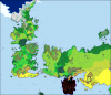
Grey is either inhospitable due to contamination, or because rogue military AI 'Machines' patrol the region. In some places they just sit on the land, in other places they're in a state of open war with humanity.

Blue is the Capricorn Union, a hyperpower in this world, with two-fifths of the planets population and two-thirds of the planets arable land. They also support the Republic of Ireland and the United Kingdom*, the last hold-outs of European civilization on the continent, and have the best access to Antarctica. Their founding members were Chile, Argentina, South Africa, Australia, and New Zealand, with Paraguay, Uruguay, Nigeria, and Madagascar joining as full members, most of the rest of southern Africa joining South Africa's Union (and so are not full members), and Mexico, Brazil, Sri Lanka, Thailand, the Philippines, and the Ice Sea Group (refugee state on ships, islands, and rigs around the southern oceans) closely aligned.

Yellow is the Pearl Cities League, mainly city-states and territories around the Tropics that use domes or arcologies to survive the inhospitable climate. What started with Singapore and the Persian Gulf now includes the northern portion of South America, Senegambia, Rwanda, the Somali Coast, Ethiopia, southern Yemen, northern India, and Indochina, as well as the Inner and Outer Islands (of East Asia, a refugee state on reconstructed and artificial islands in the South China Sea and south Pacific).

Green is Egypt, the worlds non-aligned power. It's on friendly terms with the Capricorns and the Pearls, it's on the front-lines with the Machines, even taking back portions of the Mediterranean coast of Europe, and it controls the major sites of three major world religions, through the semi-independent states of the Papal State for Rome, the State of Israel for Jerusalem, and the Kingdom of Hedjaz for Mecca. They do have rivals vying for control of the Sahara, a larger Lake Chad, and a greener western Sahara (not yet pictured).

The more yellow-green are non-aligned city-states, barely even united with each other, and usually on the edge of disaster due to expensive and failing climate control measures. In Iran and Afghanistan, they are more united, facing down the Machines that control Central Asia, unity is their only option.

*now with a major population center in the Falklands
 

Lusitania

Donor
There are some things I do not understand:

* Portugal is on the British block... but some of her claims overlap with British claims,
* Spain is on the French block, she claims Morocco. France does not... but France gets Morocco.

Both the Portuguese and British while allies had different competing visions of Africa. The Portuguese wanted to link two traditional Portuguese territories Angola and Mozambique while the British dreamed of a British Africa from Cape Town to Cairo. Each country had their explorers and staked their claim.

The British became angry at Portugal’s claim including the recruitment of France on their side threatened war if the Portuguese did not withdraw their claim.

As for morocco there were traditional Spanish claims since Spanish had held several coastal enclaves for centuries. The French were on a blue map project and had over the last 50 years taken control of Algeria. The saw the rest of North Africa as theirs. They took Tunisia and desired Morocco too. Like British attitude towards weaker and smaller Portugal the French was the stronger and more powerful than Spain. So it got Morocco and allowed Spain to expand their enclaves
 
Well, I went back PAGES in this thread and could find nothing that remotely related to the post. The member had not previously posted for about 14 months. That makes the post both off0topic and having more than a bit of current politic/gun control air to it.

What!?! I simply responded to a map of modern day Mediterranean islands ISOTed to an early roman empire, 1 or 2 pages back. I made no political statement whatsoever. And the issue of a few hundred thousand firearms will most definitely "affect" the roman legions when they come knocking.
Am I making sense?
 
View attachment 478668View attachment 478669
URHAFAH religion today by province. Note that there are still some blank spots (Zambia, Taiwan, Antarctica).
Most of this based on previous maps (Religious Map, Religious M-BAM); Central Africa has doubtful accuracy however.
Pretty sure Antarctica is mostly Pescatarian, outside of maybe the colonial and research outposts. Also might be wise to have a minimum level of settlement for an area for it to be colored in. Also, what does the coloring in Korea signify? A spot you are still taking care of? Might also want to change something with the Eastern Orthodox. Though I admit maybe they do all consider each toher in the same church in the way you show. I might be thinking of a greater diversity due to those fomrmin the Middle East historically that are not a majority in any region on the map. Might actually also be a good idea to put an 'Other' option. That all being set, I can't imagine making the map myself.
What!?! I simply responded to a map of modern day Mediterranean islands ISOTed to an early roman empire, 1 or 2 pages back. I made no political statement whatsoever. And the issue of a few hundred thousand firearms will most definitely "affect" the roman legions when they come knocking.
Am I making sense?
This is part of why we usually either quote the post we are referencing or we do a @MemberName to signify them. It both clears things up and prevents it from making it seem like someone is trying to get the last word by not letting other people know they responded. To saying you did, just something that had annoyed me in the past when people would refuse to even when asked.
 
Top
Status
Not open for further replies.
Top