Map Thread XIII

Status
Not open for further replies.
As to the Lusatia proposal, yes that happened. In fact, after WWI, Lusatians and Silesians made a joint proclamation that they wish to join Czechoslovakia. Thing is, the Paris peace conference and adjoining treaties were a long series of hypocrisies. You can see national interest put forward in one and suddenly extreme political decisions in another. So you can't really bet on what should or shouldn't have happened because it all depended on what suited the allies most at the time.

(Upper) Silesia might've become part of Czechoslovakia, too?

They would've been just a country (and a Piłsudski) away from having to change the state's name to Zapadoslavia. :D
 
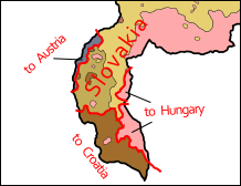
That's a lot of ethnic... um... "replacement". And with ethnic borders like those, it doesn't look like the Velvet Divorce will be velvet-y at all in your ATL, unless the Slovaks will be willing to let the Czechs have an exclave bordering them, Austria, Hungary and probably Croatia as well. There was a proposal to annex Lusatia to Czechoslovakia, too. A Czechoslovakia comprising Lusatia, the Czech corridor and the entirety of Carpathian Ruthenia (major butterflies would have to flap their wings in the USSR for such a thing to happen, though) would've been quite an interesting place.

And Petike's worst nightmare, too. :D

I guess that Hradska would become independent? Something like a miniature Switzerland or Belgium.
 
My world map in plate caree projection. I'm hoping to make this into a new standard map format for those who want to do world maps in this projection.

Everything (both borders and coastlines) still needs a massive clean-up. But at least now all the broad-stroke work is done.

If anyone has specific advice about the best way to work on cleaning up those edges (other than "systematically"), I am all ears.

Deviantart full version: Link

Thumbnail version below

plate_caree_with_country_shading_by_ashtagon-d9g7kz8.png
 
(Upper) Silesia might've become part of Czechoslovakia, too?

They would've been just a country (and a Piłsudski) away from having to change the state's name to Zapadoslavia. :D

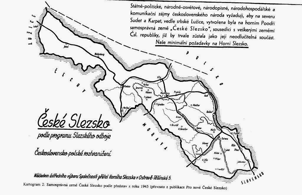
Well there were many Silesia-oriented proposals. One of the more famous ones is this (image below). Disregarding the fact that Kladsko (that rectangular protrusion) is historically a part of Bohemia (the region, not country) and not Silesia, it's pretty interesting :)

Slezsko+1945+c%CC%8Ceske%CC%81+uzemni%CC%81pozadavky.jpg


I guess that Hradska would become independent? Something like a miniature Switzerland or Belgium.
Well, firstly, when talking about it, it's Hradsko :D Hradská is an adjective ;)
And secondly, I can't really imagine that, especially due to the ethnic makeup after the resettlement. Perhaps it might have been split between the neighboring nations. Something like this:

minimap_by_soaringaven-d9g85fy.png
 
My world map in plate caree projection. I'm hoping to make this into a new standard map format for those who want to do world maps in this projection.

Everything (both borders and coastlines) still needs a massive clean-up. But at least now all the broad-stroke work is done.

If anyone has specific advice about the best way to work on cleaning up those edges (other than "systematically"), I am all ears.

Deviantart full version: Link

Thumbnail version below

Wonderful job. I think the edges look fairly clean already, although I agree that it would be possible to improve them further. I don't know of any quick solution, but I will say that it seems to be mainly the national borders that need correcting, not the coastlines. While they both have inconsistent line thickness, this could be considered a good thing in the case of the coastlines, since it helps highlight particularly jagged regions like Norway and Quebec. For the borders, however, it might be possible to write a formula that detects instances of 3 black pixels in an L-shape, and deletes the middle one. This method would address some of the 2-pixel wide splotches, but it might overdo its job, leaving fewer black pixels than we want. However, if it over-erases, that might still be an improvement over the current situation, leaving less work to do by hand.

Anyway, it's an amazing map. I especially love the inclusion of quite a few of Canada and Tibet's tiny lakes, and I'm pleased to see that most African countries got their own color this time! Thanks for working so hard on it!
 
My world map in plate caree projection. I'm hoping to make this into a new standard map format for those who want to do world maps in this projection.

Everything (both borders and coastlines) still needs a massive clean-up. But at least now all the broad-stroke work is done.

If anyone has specific advice about the best way to work on cleaning up those edges (other than "systematically"), I am all ears.

Deviantart full version: Link

Thumbnail version below
*image snip*

You're using Natural Earth III from http://www.shadedrelief.com/natural3/index.html as source, yes? Not matter what it's going to be a challenge to make it simple. Experiment with converting the source to an indexed image with a very limited colour pallet. Having a plate caree option is for standard maps will be a plus for mapmaking on this site as so many source images are in that projection or can be manipulated to fit it. Plus you can convert it to a sphere!
Cugmabd.png
 

Tardis218

Banned
For Chogyal And Country

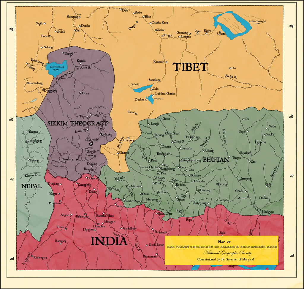
If one were to go north towards the grand Himalayas, yet stay in the borders of India one would come across an oddity. In between the rest of India, Bhutan, Nepal, and Tibet lays a small Indian state named Sikkim. The southern half is covered with mountains, which stretch into its neighbors while the other half is relatively flat. Buddhist temples are scattered across the landscape, but there is an oddity: Many places of European pagan worship. Especially, in the capital of Gangtok, where there are hybrids of the pagan worship buildings and Buddhist temples. And if one were to go on October 31, the grand harvest festival occurs. Children wear masks, neighbors invite one another for meals, and gigantic parades fill the streets. One might think a pagan religious group came recently, but you would be wrong. This can date back over 100 years ago. The British Empire was itself a mix of paganism and Christianity, and odd off-springs of paganism, Christianity, and native religions happened often. But, it was not expected in the mountainous area of northern India. When Sikkim was an independent kingdom, the British used it. For one, British merchants often traveled through the kingdom to trade in Tibet. Another was to use Sikkim as a base to quell Russian influence in the area, so with the permission of the Chogyal, a small British garrison was stationed at the capital at the time, Yuksom. And in Yuksom, the first place of pagan worship in Sikkim was built for the garrison. As the decades went on, and Sikkim became a British protectorate in 1861, missionaries came in, starting with a group of 10 who were sent to the British garrison. Members of the Sikkim royal family began converting, to help with influence between the two nations, which sparked much interest with the natives. Soon enough, Sikkim was a hive for these missionaries. Many who had the highest ranks among the religious officials and became a British governor of Sikkim, cementing influence between church and state. By the time 1947 came, the British were leaving India, but before they could leave they were partitioning the sub-continent up. The governor of Sikkim pleaded for independence, and a vote was held among the people of Sikkim whether to become part of India or not, most voted for the latter. Tensions slowly rose between the people, the Chogyal, and the Prime Minister of Sikkim.The people wanted a true democracy, so anyone from Sikkim could become Prime Minister, instead of a small group of religious heads, the Chogyal was Buddhist and saw a pagan Prime Minister has a threat, along with even having a Prime Minister. Protest after protest the stability of the government went down, before finally in 1975 the Prime Minister of Sikkim and the Chogyal proposed for Sikkim to become part of India, a referendum was held, a majority voted in favor of becoming part of India. The British garrison is long gone, the first building of pagan worship in Sikkim was lost in a storm, and many other signs of Sikkim’s past are gone, but the few foreigners who walked through those parts of Asia, will most definitely learn about the odd little history of Sikkim.


for_chogyal_and_country__by_tardis218-d9f3q3e.png
For-Chogyal-and-Country-569563610
 
1962 ATB final.png

After the Bombs

In October 1962 the world faced the horror of a global nuclear war with bombs landing on the three continents of Asia, Europe and North America

The remaining two months of the year saw drastic changes to the global geo-political landscape.

The USSR that suffered the most damage besides Cuba and Germany was collapsing as the republics were declaring independence as Moscow was obliterated and the Soviet military lost most of its force. The Warsaw pact fell apart as the leaders of the eastern block countries attempted to establish dominance over their people and of Eastern Europe.

Cuba was bombed most heavily and invaded by the US, most population centres were devastated and agricultural land poisoned by radiation and other contaminants resulting in a large numbers Cubans fleeing towards Florida, Haiti, Mexico, The Dominican Republic and other Caribbean Islands.

The British capitol London was flattened as were many cities across the Island, In November the new government recalled the British Army back to the UK and declared that any of its colonial empire that whished for independence would be granted. Hong Kong was surrounded by the PLA a few days after the Bombs fell and a quick negotiation a peaceful handover was secured.

The French government did not call back its military back home and still hoping to maintain an empire, which did not stop many Pacific Island territories including New Caledonia from declaring independence.

The United States suffered destruction of major cities including the Washington D.C.
Florida was bearing the brunt of the Cuban Diaspora as most it suffered the most damage.

Germany suffered largely as both east and west was bombed to make way for the advancing armies, although very little actual fighting did occur on German soil as the most of the foreign military force were destroyed.

North Korea invaded South Korea quickly after Soviet bombs fell on many US military basses and quickly unified the peninsula.

Japan had suffered attacks on the US basses on the archipelago and the Okinawa was bombed heavily and in response Japan declared the annexation of the Island Group.

Malaya, Indonesia both sent tropes to occupy the disputed area of North Borneo and Sabah. While the Philippines sent its navy to patrol the coast of Sabah.

1962 ATB final.png
 
A Russian In the Pacific​

A commission for Nick Griffalco based on this scenario.

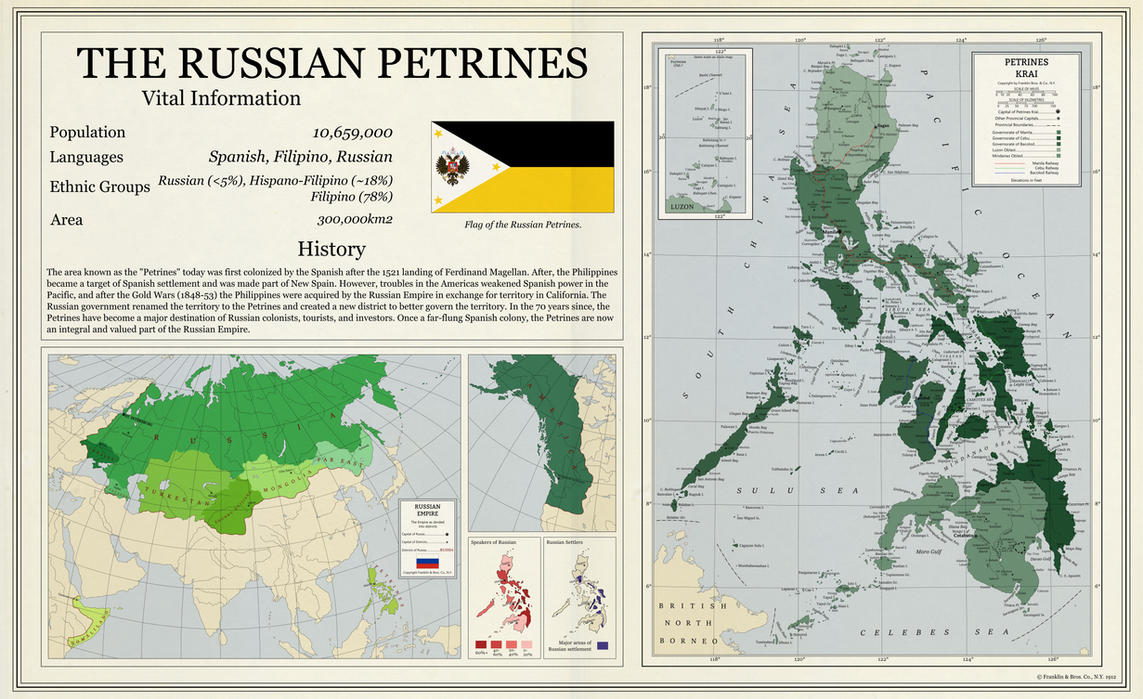
Essentially, the Russians are more Pacific-oriented with a better Pacific fleet early on, and go on to conquer parts of Qing China, more of the Americas, and take the Philippines from the Spanish in return for Californian coastline. While initially not an incredibly valuable trade, Russia has since built up its little empire of the Pacific, furnishing the Petrines with railways, schools, universities, hospitals, and more. Unlike the Spanish, the Russians sought to integrate the Petrines directly into their territory, creating a Krai out of it and dividing said Krai into three governorates and two oblasts.

Colonization comes from all over the Russian Empire, with Africans, European Russians, Ukrainians, Poles, Turks, Siberians, and Jews all settling in the Petrines and helping to make it truly part of Russia. Just about 70 years after acquiring it, a large amount of the population speaks Russian as a first or second language as both the wealth and population of the Petrines continues to grow.

If you want a commission like this, feel free to contact me on here via a PM. If you want to support me and see more maps like this, consider donating to my Patreon.

Full size map here.

a_russian_in_the_pacific_by_toixstory-d9ga3n2.jpg
 
After the Bombs.
Did the Japanese claim Okinawa against American wishes? And if I recall the U.S. Wanted them to keep up the Japanese claim to those islands in the southern Kuriles. Why did they renounce claim to those islands, instead going for an irradiated mess? And did the Korean army units in South Korea get caught up in the nuking of American bases? And why didn't the U.S. nuke the North?Is the area south of Moldavia independent, Ukrainian, Russian, etc? And are their autoimmune or disputed areas in the former Soviet Union not shown due to the complexity, or because like in the Azeri-Armenian thing certain countries just won't accept it? Portuguse lose Macau same time as the British Hing Kong? Why did the British keep Zanzibar, Aden, and Bahrain? And it is amusing with the French, how they tried keeping their empire but only seemed to have their Carribean islands, besides for managing to get the Mexicans to drop their dispute over the ownership of a single island. Which side was given the British bases on Cyprus? The Malays not going to force Singapore to keep out of Malaysia in this? And will the focus of the Indonesians on Borneo end up with them losing out on New Guinea and Timor to expanding Australian hegemony?

Don't consider this too much as being criticism. More that I am interested in the story and know there is some info that can't be put in the main text that goes with a map without breaking the flow of the writing.
 
Top
Status
Not open for further replies.
Top