50 States of Equal Population/Electoral College

Status
Not open for further replies.

Wallet

Banned
electoral10-1100.jpg

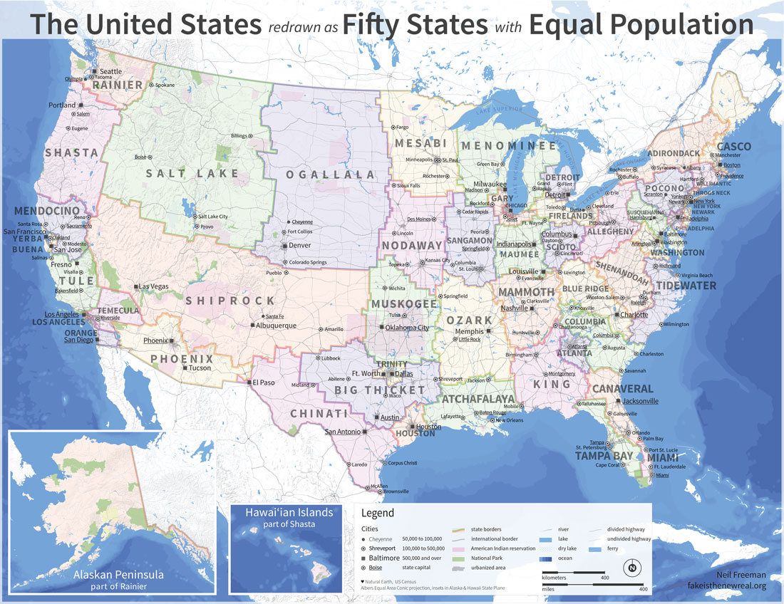
This map is what the US would look like if it was 50 states of equal population. This was recently posted in chat. What states would vote Republican and what states would vote Democrat? And what would the electoral collge look like. Assuming each state has the same amount of electoral votes, then winning the most states woud win you the election?
 

Wallet

Banned
  1. New York (D+31)
  2. Yerba Buena (D+24)
  3. Los Angeles (D+20)
  4. Chicago (D+19)
  5. Washington (D+16)
  6. Philadelphia (D+13)
  7. Throgs Neck (D+10)
  8. Miami (D+9)
  9. Willmantic (D+9)
  10. Newark (D+9)
  11. Casco (D+8)
  12. Detriot (D+8)
  13. Temecula (D+7)
  14. Rainier (D+6)
  15. Tule (D+6)
  16. Shasta (D+6)
  17. Adirondack (D+6)
  18. Mendocino (D+5)
  19. Firelands (D+8)
  20. Gary (D+3)
  21. Mesabi (D+3)
  22. Tidewater (D+1)
  23. Sagamon (EVEN)
  24. Orange (R+1)
Romney States (in order of Cook PVI):

  1. Susquehanna (R+2)
  2. Pocono (R+2)
  3. Menominee (R+2)
  4. Atlanta (R+3)
  5. Shenandoah (R+4)
  6. Ogallala (R+4)
  7. Shiprock (R+4)
  8. Tampa Bay (R+5)
  9. Cumberland (R+5)
  10. Chinati (R+5)
  11. Nodaway (R+5)
  12. Canaveral (R+6)
  13. Phoenix (R+6)
  14. Dallas (R+6)
  15. Scioto (R+6)
  16. Maumee (R+8)
  17. Houston (R+8)
  18. Ozark (R+9)
  19. Atchafalay (R+10)
  20. Columbia (R+11)
  21. Blue Ridge (R+11)
  22. King (R+13)
  23. Franklin (R+15)
  24. Big Thicket (R+16)
  25. Salt Lake (R+17)
  26. Muskogee (R+18)
This list was made by Reagent
 

Asami

Banned
Oooh. Tampa Bay being it's own state? Me likey.

Even if it is now firmly Republican. >>
 
GARY, you stuck me in Gary! With Joliet as the state capitol. I fart in your general directon. Your mother was a hampster and your father smelled of elderberries.
 
I made a PNG of the map. Some of the borders are slightly off because I was following county lines (most notably Reno being in Shasta instead of Mendocino because of keeping Washoe County whole), but I did the best I could to get the borders right.
 

Attachments

  • 50 States Equal Populations Map 2012 Election.png
    50 States Equal Populations Map 2012 Election.png
    125.6 KB · Views: 3,698
One thing that's always struck me as odd about this map are the names of all the states- such as the Boston-based state being named Casco (a small town and inlet of the Gulf of Maine). Some of the borders in the Northeast could also use a bit of a readjusting, as areas such as western Maine and Buffalo, NY as well as Stockbridge and Scrantion being paired up with each other are a bit unusual. Otherwise, it's a pretty decent map.
 
Is Reno part of Mendocino, Shiprock or Shasta in that map, OP? If you want to see a city destroy itself...just make it a border town between 3 states that would all have significant support.
 
Here's the larger map.

map--50.jpg


Is Reno part of Mendocino, Shiprock or Shasta in that map, OP? If you want to see a city destroy itself...just make it a border town between 3 states that would all have significant support.
From the large map it looks like Reno is part of Mendocino.
 
Status
Not open for further replies.
Top