Map Thread VI

Status
Not open for further replies.
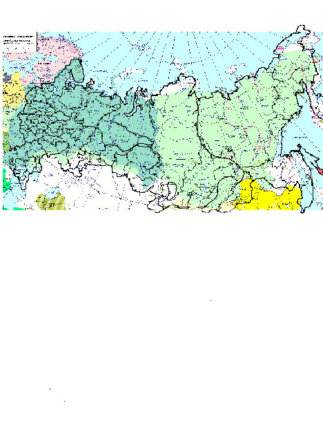
My Progress on the "Superimposed Russia" Map

Well, folks, I found a much better map to do my Russia project on. It's Siberia_Federal_Subjects.png on the wikimedia commons. Since the provinces had "sealed" borders it made my work much faster and easier. I'm still working on it. I'll have to compensate a little since the svg map is a bit larger than the historic one, but you can see how it's turning out here:

AlmostRussia.png


Anyway, remember the green map underneath is Russia's boundaries from c. 1648 -1667, the closest Russia has ever come to today's borders

Happy Mapmaking to all! :)
 
Here's 09camero's request!

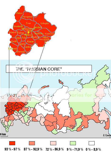
Luckily, I found a map on wikimedia commons that allowed me to make my "Russian Core" Map very simple. Here's the updated version of the "Russian Core" along with the names of the 21 majority-Russian provinces. I use the map I originally got the idea from:

EthnicRussians.png


Thank You!:)
 
Was that after the crown prince massacred most of his family?

Bruce

Well, their was that, but the Monarchy had been acting authoritarian for years, their'd been an anti-monarchy insurgency since the early 90's and the King tried to abolish the legislature.
 
I like the atlas-like style and the thought that went into it. Nice storyline, plus a very nice looking world map.

Danke.


Might want to explain how a territory with 90%+ Han Chinese majority would have any sort of realistic secessionist movement favoring Union with Mongolia.

Mengjiang is at the heart of Inner Mongolia, only taking up about half of Inner Mongolia, and OTL the entirety of Inner Mongolia is only ethnically 80% Han at the present it would generally be less Han, however in addition to this ITTL part of the agreement was that the Han would be encouraged to move to the state of China, and even before this the Japanese had been forcefully deporting them in order to create a strong puppet.


though the idea of nationalism developing out of the the Guangxi Clique is somewhat odd)

Like several things in the TL you can thank the French for that, they started negotiations with and influencing Guangxi in the mid-30's and were among the few countries who actually recognized them as independent.

Do to the loose structure of the Federation Guangxi retained some areas of economic and diplomatic powers and have had close relations with France and the 'West' all the way to the present, which has caused a situation where culturally and politically Guangxi is more European than Asian.
As a result of all of this a sense of Guangxi as an independent, unique entity has developed over time.
 
Luckily, I found a map on wikimedia commons that allowed me to make my "Russian Core" Map very simple. Here's the updated version of the "Russian Core" along with the names of the 21 majority-Russian provinces. I use the map I originally got the idea from:


Thank You!:)
i requesrted this? well.. it will come in handy. :D
 
Thanks Q!

Hey, has anyone ever done the non independent bantustans in South Africa and South-West Africa as internal divisions in any of the UCS maps? That might be interesting.
Not a problem, man, you're welcome.:) As for depicting the Gaza Strip on the Dymaxion map, your way is about the only way to do it, BUT, I as a perfectionist, don't really like the way it looks, so that is why I left it out on my maps, for I prefer not to have it there rather than having it look screwy. As for the non independent Bantustans in both SA and SWA, I agree it would be interesting to show them on a map. Maybe that will be something I may do. I actually have some old CIA maps from the 1970s of SA and SWA that show both independent and non independent Bantustans, I just need to eventually dig thru my boxed up map collection that I have been amassing over the years, and see if I can find them.
 
Another depressing one, alas… :(

A world in which Germany never allied to Japan, instead moving to closer relations with a more openly fascistic China. Thanks to Hitler’s timely assassination, there was also no invasion of the USSR. Things got a bit sticky for a while after the British development of the atom bomb, but in the end cooler heads prevailed, and after the British Commonwealth fell apart, a rough four-way balance of power prevailed for a few decades, between the US-dominated western hemisphere and Australasia, the USSR, the Reich-Chinese alliance, and the Empire of Japan, which although ejected from China by a Chinese resistance armed by Germany and the USSR, still held onto Korea and a sizeable little SE Asian empire.

Things went pear-shaped when the US went fascist in the 70’s, launched a nuclear first strike against Japan and took over much of its empire (Vietnam proved...troublesome), and went on an orgy of conquest in the Americas which only ended with a “limited” nuclear exchange (a few millions on each side) with the German Reich. Its Jews and Asians have been murdered or expelled, its blacks for all intents and purposes re-enslaved, and is currently engaged in a murderous arms race with the German-Chinese alliance and the USSR and its allies – which have formed a shaky alliance in the face of the American Menace.

The Reich has mellowed, and nowadays is an only occasionally brutal one-party state, with the Fuhrer now replaced by a Chancellor with limits on his powers, and the US is a nasty reminder of the Bad Old Days (and, troublingly, an inspiration to some who want said days back). The Reich is still institutionally racist, but things have improved to the point where the Reich now fields black colonial regiments and they’ve even got rid of the Nuremberg laws (although very few Jews fleeing the US have shown interest in the Reich as a refuge location). The Jews were driven out rather than exterminated, and there is an actual state of Israel – a leftish Soviet ally in an area where the Soviets have no other friends. (Iran is an often-restless puppet).

The Arabs, along with whites-only, nuclear-armed [1] Australia, are the only states that are US allies by choice rather than compulsion, and relations are still prickly (Arabs are not allowed to settle in the US, for one thing). Japan and Korea avoided US invasion (the USSR and the Chinese both were pretty definite on that) but is still recovering from the loss of more than half its population, and ironically is to some extent a Chinese puppet nowadays. The USSR has been undergoing not too successful spasms of economic reform since the 70’s, and although the hostile outside environment has helped keep the state unified, is in poor shape and heavily dependent on Chinese and German economic support (given out of fears of civil war and perhaps the loss of an ally to the US side). India is leftist but also rather Hindu nationalist, and has problems with Islamic unrest. The Italian Empire still toddles along under Fascist control, and is woefully corrupt and suffering from a serious insurrection in Tunisia, for which out of national pride it has refused German support.

China, run by the Kuomintang party, is richer than OTL (it started booming economically in the 60s rather than the late 70s), although not quite a superpower yet. It is understandably nervous about the Americans, and closely tied to Germany, their biggest trade partner and investor. Chinese immigrate in large numbers to German colonies, and provide a lot of warm bodies for German “peacekeeping” forces. The UK, along with Finland and Sweden, are still more-or-less democratic, although the UK has been forced to “come to an understanding” with the Germans, which help protect Newfoundland and New Zealand from the US. A few fragments of the old Commonwealth still remain associated with the UK, due to fears about their neighbors and a lack of interest in joining the somewhat moth eaten Communist International. South Africa is still racially segregated, if no more repressive than OTL 1980s, and is notable, after a post-1976 wave of refugees from the US, in having the world’s fourth largest Jewish population after the UK, Russia and Israel.

Bruce

[1] They've been worrying about the Yellow Menace for a long time.
 

VT45

Banned
The regional co-official languages of Western New England (haven't gotten to Maine yet), as laid down in the year 2000.

untitled.PNG
 
Looking for input here, if I might receive it.

I'm working on the map of the western world for my story, and after the first few maps of mine using rather generic icons for the map, I - in a blast of sudden creativity - ended up making some cool (IMO) new icons which combine a number of my previously downloaded brushes. That said, these icons that you'll see are compiled from other peoples work. The modification and combination thereof is mine, as is the map.

This is just a close up of Erresuma, which is modeled after a republican Britain, and my question specifically is (in addition to whatever pairs of pennies might be thrown my way), does the number of icons on the map make it look cluttered?

Untitled-1.jpg
 

Thande

Donor
It's a good idea in theory, but I think it would look better if the icons were a bit smaller and if perhaps you could introduce a bit more variation in the look of them, as that tends to be the norm in fantasy maps (the little icons representing cities on fantasy maps are usually similar but not identical).
 
Top
Status
Not open for further replies.
Top