Say, in 1960-es.
Mega-project for "peaceful utilization of nuclear explosives" and geo-engineering by USSR.
Ref.s:
1. http://en.wikipedia.org/wiki/Sedan_Crater ,
2. http://en.wikipedia.org/wiki/Sedan_(nuclear_test) ,
3. http://en.wikipedia.org/wiki/Operation_Plowshare ,
4. http://en.wikipedia.org/wiki/Peaceful_nuclear_explosions ,
5. http://en.wikipedia.org/wiki/Peacef...:_Nuclear_Explosions_for_the_National_Economy,
super-version of the Op.Plowshare's offshot - the Panatomic canal proposal for Nicaragua.
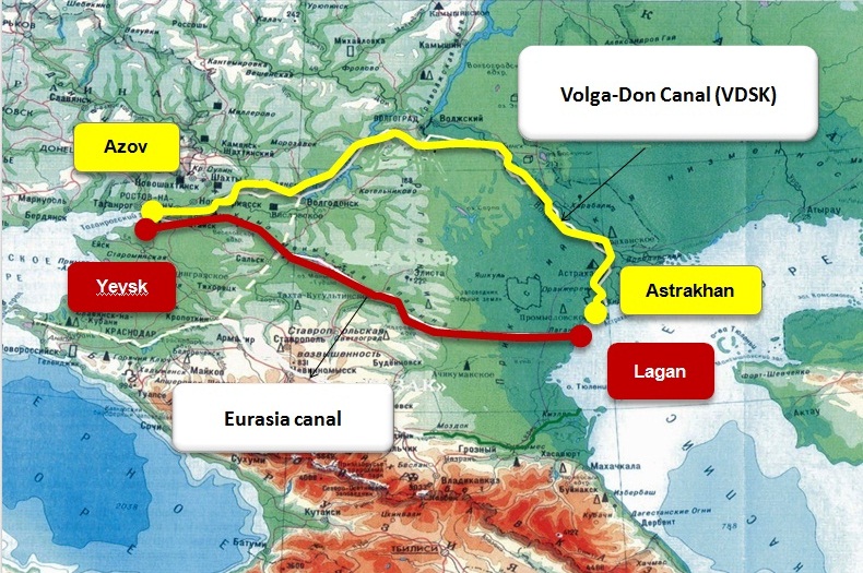
From the mouth of Don River at Rostov-on-Don to Kransoarmeysk rajon of Volgograd. ( where the elevation is around zero ), following the bed of Don and Volga-Don canal ( + some under Asov sea to let smoother flooding )...
About 600 km long "atomic canal" - hundres of meters wide and dozens to hundreds meters deep.
Several thousand of hundreds of kT range devices, burried deep enough to avoid almost all fallout issues.
Lower Don disappears turned into a "oceanic passage". Caspian basin fills up to the world ocean level. No locks, no dams.
Caspian countries become instantly Mediterranean ones...
The best map I could find :: http://www.davidrumsey.com/luna/ser...no_initialsort,pub_date,pub_list_no,series_no
Mega-project for "peaceful utilization of nuclear explosives" and geo-engineering by USSR.
Ref.s:
1. http://en.wikipedia.org/wiki/Sedan_Crater ,
2. http://en.wikipedia.org/wiki/Sedan_(nuclear_test) ,
3. http://en.wikipedia.org/wiki/Operation_Plowshare ,
4. http://en.wikipedia.org/wiki/Peaceful_nuclear_explosions ,
5. http://en.wikipedia.org/wiki/Peacef...:_Nuclear_Explosions_for_the_National_Economy,
super-version of the Op.Plowshare's offshot - the Panatomic canal proposal for Nicaragua.
From the mouth of Don River at Rostov-on-Don to Kransoarmeysk rajon of Volgograd. ( where the elevation is around zero ), following the bed of Don and Volga-Don canal ( + some under Asov sea to let smoother flooding )...
About 600 km long "atomic canal" - hundres of meters wide and dozens to hundreds meters deep.
Several thousand of hundreds of kT range devices, burried deep enough to avoid almost all fallout issues.
Lower Don disappears turned into a "oceanic passage". Caspian basin fills up to the world ocean level. No locks, no dams.
Caspian countries become instantly Mediterranean ones...
The best map I could find :: http://www.davidrumsey.com/luna/ser...no_initialsort,pub_date,pub_list_no,series_no
Last edited: