A Blank Map Thread

Could someone help me out with a blank version of this, keeping rivers if possible?
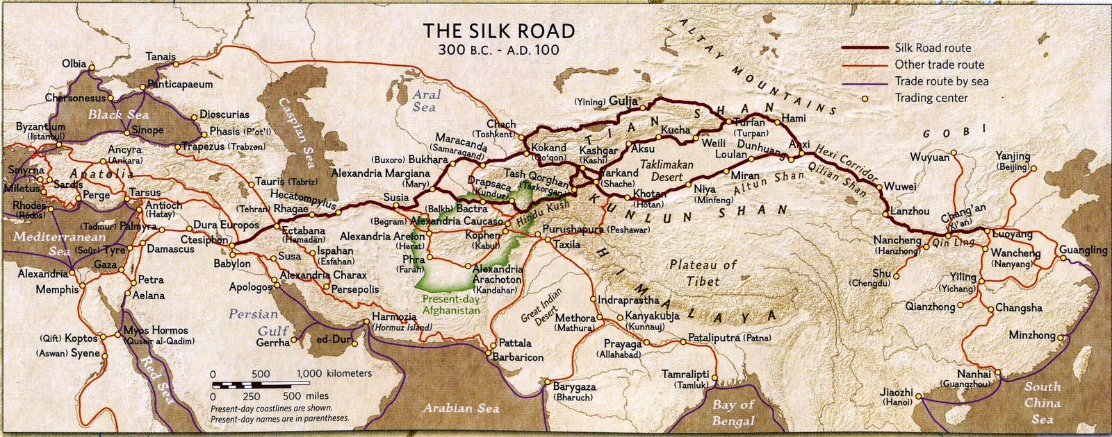
Silk-Road-Map-Afghanistan-show-Hiebert-PENN.MUSEUM.jpg
 
I need a plain world map with as many rivers as possible like the one below, however the wikilook or whatever it is called I don't want, also it needs to be of a larger size; I need the detail. I had it as a 4974 x 2519 (perfect size) but is to large to upload for direct size comparison so had to shrink it.

I've looked through something like the first 60 odd pages of this thread and on the wiki so I have tried to find something :p. Thanks for any help.

Alt history size .png
 
I need a plain world map with as many rivers as possible like the one below, however the wikilook or whatever it is called I don't want, also it needs to be of a larger size; I need the detail. I had it as a 4974 x 2519 (perfect size) but is to large to upload for direct size comparison so had to shrink it.

I've looked through something like the first 60 odd pages of this thread and on the wiki so I have tried to find something :p. Thanks for any help.

I have that one with sub-national subdivisions, but that's about it. It's called Qbam (qazak big ass map), for reference.

Also, don't take the rivers on that one at face value; the guy who made it needed to touch up on it a lot and never got around to it.

I also have it with counties in the US and counties/regional districts in Canada. It also has sub-subnational regions of Germany, France, and the UK. Unfortunately it isn't on a globe shape like that.

Ah well if the rivers aren't to accurate and there is one with more internal divisions of nations then sounds like your one will do. It's NOT globe shape because I don't want it to be?

Whereabouts are the two maps you mention?

Thanks for the help.
 
Ah well if the rivers aren't to accurate and there is one with more internal divisions of nations then sounds like your one will do. It's NOT globe shape because I don't want it to be?

Whereabouts are the two maps you mention?

Thanks for the help.

Sorry, I'll upload 'em this afternoon. It's too large a file to do in one go on here, and imgur resized it. I'm in class now, my last one ends at 11 and I'll take care of it then.
 
I am a huge fan of the huge Europe maps, especially the series made by Valdemar from around 1600 up until 1815. I noticed this little beauty in an older map thread:

Link to avoid stretching the page

And I was wondering, any 19th century big Europe maps? Now, 1914 will pretty much cover anything past 1871, but I always found Valdemar's 1814 map... a bit empty. Lots of white and nothing like say, 1650. Now, there weren't a lot of changes, but even a map in this style, with provinces in all, would be quite useful in some of the periods that borders did change (German and Italian unification come to mind -- even the Revolutions of 1848). Germany would look so, so much more interesting in that period with it's multitude of principalities.

Any takers or leads?
 
I have searched high and low for a world map that breaks down all nation-states into their provinces. A huge thank you in advance to the person that can direct me to one or provide me with a link!
 
I appear to have forgotten a request for a Qbam last week, which I will try to remember to upload later today, and I will also direct you to a nice UCS with the sub-national borders, VirginiaHistoryTeacher.

If I remember. I stayed up really late last night writing a paper and I was passing out in my logic class so we'll see.
 
Top