You are using an out of date browser. It may not display this or other websites correctly.
You should upgrade or use an alternative browser.
You should upgrade or use an alternative browser.
Map Thread X
- Thread starter metastasis_d
- Start date
- Status
- Not open for further replies.
View attachment 185078
My WIP map with several adjustments made according to suggestions. I've balkanized China and am currently in the process of dividing up India between the British, French, and other colonial powers, along with several independent princely states. The PoD for the former is a succesful and more devastating Taiping rebellion; for the latter, a larger 1858 Indian mutiny/rebellion with foreign support, while Britain is occupied with other matters.
In the Americas, I returned the Rio Grande region to Brazil. Additionally, due to a USA weakened by the ACW, many powers have taken the opportunity to expand their imperialist agendas in the Americas. Italy and Germany have both taken advantage of Venezuelan financial troubles as an excuse to invade and take territory, while France has blatantly retaken its "rightful territories" in Haiti. Furthermore, there are now 2 buffer states between the CSA and USA-Deseret (on the left) and the Indian Confederation (on the right), both created via peace talks enforced by major powers. I may end up giving Brazil a pacific coast; however, other than that, South America will see no further changes. I'm still thinking about what to do with Mexico and Central America.
I've got some suggestions that I'll show you
")
I just completed my first work with Inkscape. Sorry, guys, no fantasy world or anything. It's just a small thing.
I basically outlined the Amazon Rainforest in South America, with the countries superimposed. Not too complicated. Rather obvious. A good way to test out Inkscape, I thought.
I'm thinking of doing something with the ethnic groups within Austria-Hungary next. Probably already done, but I'd like to get used to Inkscape a bit more before I get more ambitious.
Hm... Here's an idea to give you some practice: try to do mountain ranges and watersheds of the world, continent by continent. Bonus points if you use one of the basemaps (Worlda or Qbam) and post them here and in their respective improvement threads so that everyone else can use them to improve borders on our own maps. Everybody wins!
Not AH map (yet) - just trying some new photoshop techniques:
Map will be used for Nogai Horde EU3 (Magna Mundi) AAR.
Well then... you can probably make a completely contrived, terribly trite, and consciously cliché map full of errors, but using those photoshop techniques, and blow us all away.
It's one of those situations where I did some research which showed me how much research I'd need to do to properly do a timeline.
Yeah, that's kind of the reason I've never started one. All the ideas I've had, I've looked into, and realized no matter what I'd be in over my head.
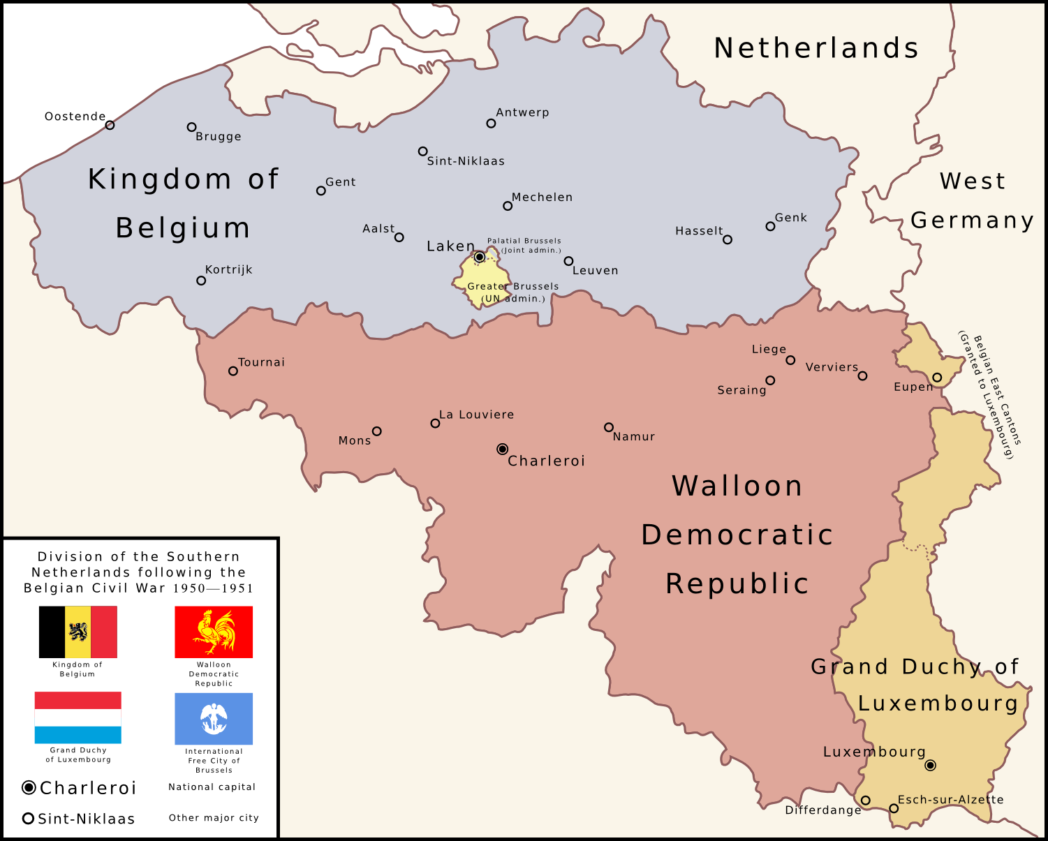
And the map;
So I'm guessing with the Soviets supporting it, the Walloon Democratic Republic is similar to other "Democratic Republics".
Also, kudos on the Luxwank.
Finally, as I didn't know about the Brussels coat of arms, and had to look it up, I thought at first that was an angel stabbing a cat.
Hm... Here's an idea to give you some practice: try to do mountain ranges and watersheds of the world, continent by continent. Bonus points if you use one of the basemaps (Worlda or Qbam) and post them here and in their respective improvement threads so that everyone else can use them to improve borders on our own maps. Everybody wins!
Subtle. You realise that vectors and the basemaps don't really get along, right?
Yeah, that's kind of the reason I've never started one. All the ideas I've had, I've looked into, and realized no matter what I'd be in over my head.
What slows me up is that I always get overwhelmed by details - both in terms of the subtleties of the situation, and also by all the little changes that you could make which then go on to have huge implications. Also, that I'm not American, and know virtually nothing about US politics, and people don't seem to be happy with a timeline unless there's an enormous part of it focused on how, say, the Shah being overthrown in favour of a multiparty democracy is directly responsible for Pat Buchanan establishing a theocratic state. Or whatever.
Nietzsche
Banned
My WIP map with several adjustments made according to suggestions. I've balkanized China and am currently in the process of dividing up India between the British, French, and other colonial powers, along with several independent princely states. The PoD for the former is a succesful and more devastating Taiping rebellion; for the latter, a larger 1858 Indian mutiny/rebellion with foreign support, while Britain is occupied with other matters.
In the Americas, I returned the Rio Grande region to Brazil. Additionally, due to a USA weakened by the ACW, many powers have taken the opportunity to expand their imperialist agendas in the Americas. Italy and Germany have both taken advantage of Venezuelan financial troubles as an excuse to invade and take territory, while France has blatantly retaken its "rightful territories" in Haiti. Furthermore, there are now 2 buffer states between the CSA and USA-Deseret (on the left) and the Indian Confederation (on the right), both created via peace talks enforced by major powers. I may end up giving Brazil a pacific coast; however, other than that, South America will see no further changes. I'm still thinking about what to do with Mexico and Central America.
I love this map simply because Tennessee is not a member of the Confederacy. It's so rare to see them left out, even though they were dead-last to leave the Union, and even then, there's good reason to believe the vote was tampered with.
I'm not fond of my home state for various reasons, but god damn it, we weren't throwing ourselves into the Confederate's groping hands.
I thought at first that was an angel stabbing a cat.
CANNOT UNSEE
I do not. Nor did I know Inkscape was a vector program.Subtle. You realise that vectors and the basemaps don't really get along, right?
Yeah, I feel ya.What slows me up is that I always get overwhelmed by details - both in terms of the subtleties of the situation, and also by all the little changes that you could make which then go on to have huge implications. Also, that I'm not American, and know virtually nothing about US politics, and people don't seem to be happy with a timeline unless there's an enormous part of it focused on how, say, the Shah being overthrown in favour of a multiparty democracy is directly responsible for Pat Buchanan establishing a theocratic state. Or whatever.
So I'm guessing with the Soviets supporting it, the Walloon Democratic Republic is similar to other "Democratic Republics".
On the contrary, given it is landlocked, surrounded by western states, and isolated from the Soviet Bloc, despite some Soviet support (Greatly limited I presume by the difficulties of clandestinely shipping supplies to Austria via Czechoslovakia and then smuggling them by air freight to Wallonia) I would expect it would be largely free and democratic, although with quite leftist politics, nationalization of most heavy industry, and likely a constitution that officially proclaims it a socialist state. Less a Poland and more a politically radical France or Sweden.
Been mucking about with procedural generation.
After about 4 hours of programming, and reprogramming I ended up with this.
Its rendered in two passes. One pass comes up with height details (right now flattened for simplicitly, and a second pass to put black edging on everything. I'm surprised it came out as clean as it did really.
The full image generates at 2048x1024, and takes approximately 10 seconds. You can probably pull 4096x2048 though (but then we start looking into the minutes).
Edit: Also, as you might guess, theres pole-expansion at the bottom/top. This is a necessary evil, but I'll look into reversing this to an extent not dissimilar to the Worlda.
Is it equirectangular at present?Edit: Also, as you might guess, theres pole-expansion at the bottom/top. This is a necessary evil, but I'll look into reversing this to an extent not dissimilar to the Worlda.
Been mucking about with procedural generation.
After about 4 hours of programming, and reprogramming I ended up with this.
Its rendered in two passes. One pass comes up with height details (right now flattened for simplicitly, and a second pass to put black edging on everything. I'm surprised it came out as clean as it did really.
The full image generates at 2048x1024, and takes approximately 10 seconds. You can probably pull 4096x2048 though (but then we start looking into the minutes).
Edit: Also, as you might guess, theres pole-expansion at the bottom/top. This is a necessary evil, but I'll look into reversing this to an extent not dissimilar to the Worlda.
That's a pretty impressive image. Looks like a terraformed moon minus erosion.
Have you considered rendering it onto a sphere or icosahedron?
Is it equirectangular at present?
Its more of a Mercator projection. Its a symptom of using 3D coordinates to generate the surface (which means that the seams all match up perfectly).
That's a pretty impressive image. Looks like a terraformed moon minus erosion.
Have you considered rendering it onto a sphere or icosahedron?
It is currently rendering onto a sphere, its just the GUI right now is really unpolished and was hacked together in a couple minutes.
I think it'll look better once I add flattening in. I need to get the noise to generate in a -1 to 1 range, and then I can exponent it by a value between 1 and 2, which should variably flatten the terrain, making mountains smaller, and more pronounced features. I'm using a different noise algorithm than I've used in the past, and I've had trouble working out how to make it generate solely in this range.
Edit: Also, since I didn't implicitly say it, thats roughly a third of the map. Its a little taller (although much of the southern hemisphere is boring empty ocean), and much wider.
On the contrary, given it is landlocked, surrounded by western states, and isolated from the Soviet Bloc, despite some Soviet support (Greatly limited I presume by the difficulties of clandestinely shipping supplies to Austria via Czechoslovakia and then smuggling them by air freight to Wallonia) I would expect it would be largely free and democratic, although with quite leftist politics, nationalization of most heavy industry, and likely a constitution that officially proclaims it a socialist state. Less a Poland and more a politically radical France or Sweden.
So I guess ITTL the term "Democratic Republic" doesn't have such a stigma?
So I guess ITTL the term "Democratic Republic" doesn't have such a stigma?
Could be.
You ask that like I'm writing an in-depth TL though, not just spending a few hours on one map.
So I guess ITTL the term "Democratic Republic" doesn't have such a stigma?
Not necessarily - OTL Bangledesh is officially a People's Republic despite being a multiparty democracy.
And the map;
Excellent! If someone had said to me this morning: "today, you shall see an awesome map of Belgium" I would have been doubtful: I mean, Belgium. But this is definitely a crowd-pleaser.
Bruce
- Status
- Not open for further replies.
Share: