I Blame Communism
Banned
Sussex flows better than South England.
But as I said, Sussex is the wee bit above Kent. Wessex works as an odd poetical name, but calling southern England Scotland is like calling Scotland the Kingdom of Caithness.
Sussex flows better than South England.
But as I said, Sussex is the wee bit above Kent. Wessex works as an odd poetical name, but calling southern England Scotland is like calling Scotland the Kingdom of Caithness.
What happened to the Rocky Mountains?
The Rockies are still there, for the most part. It's an ASB map of if the sea levels rose somewhere between 1500 m and a mile.What am I looking at, fantasy map?
I am familiar with the Anglo-Saxon divisions of the England.
Highlighted in red are wrong. Where in Western Mass do you live?
Any comments on the map I posted here?
Any comments on the map I posted here?I updated the flooded western US map some. Here's a rough draft of the political entities that have developed after the disaster. I also connected Lake Lahontan to the ocean as I felt that looked better. The names in the empty lands are uncivilized tribes or other peoples without a cohesive government.
I waiting comments for my map and simple scenario.
See you later.
OK, you asked for it...
What is your normal language, A?
Not only is the UK not a republic, it’s not in North America.
Why on earth those archaic borders in Eastern Europe?
And how on Earth did the Russians re-conquer so much territory? They had trouble subduing Chechnya, and as for future prospects, the oil is getting harder to extract, and the population is still hardly replacing itself…
Very few people in that Turkestan are Turkish…
Muslim China? Christian I could sorta buy, but Islam isn’t particularly popular in China nowadays outside the minorities who traditionally practice it. Well, I suppose it’s an improvement on Eurabia. Similarly, most of those “Islamic areas” you have in India are in fact majority-Hindu. (Although the Indian ocean “Indosphere” is an interesting idea and a change from the usual “and here’s the dull colored blob of India.”)
Bruce
Since people were doing CP victory maps, i made one. But it's an alternate history in an alternate history. . .
It will be featured in my new story-timeline. Feel free to comment or ask questions.
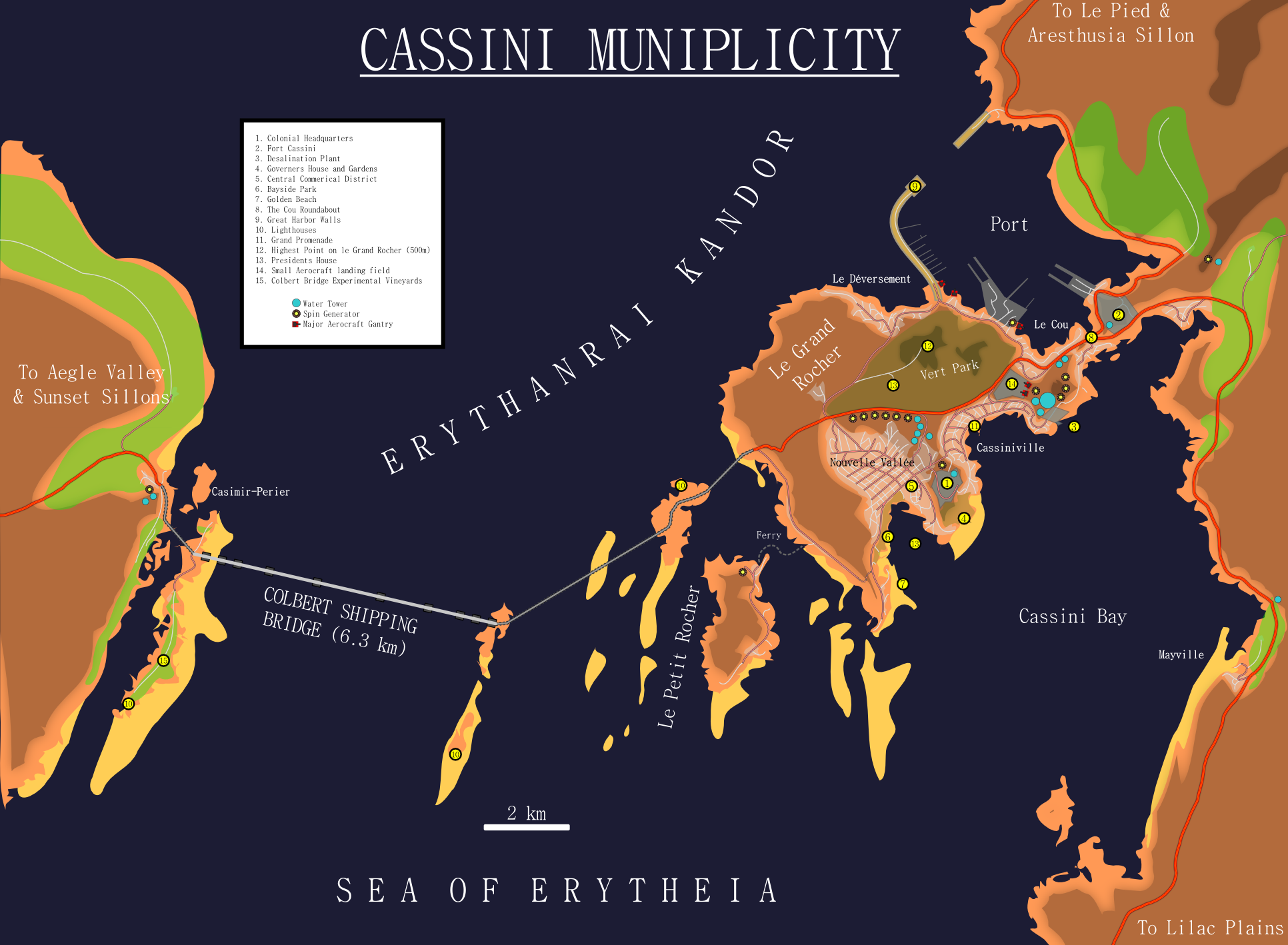
A city map for the capital of the major French Martian colony (Department Erythie) my Cavorite Solar System world.
See its location in the Acidalian basin here.
The population runs to about 80 thousand, and is the biggest French city outside Le Pied (where their space tower is, and is rather industrial and messy) and the major destination for Martian tourists. Buffered by the equatorial waters north and south it is probably the warmest place on Mars, and deep in the miles deep trench of the Valles keeps it pleasant all year round (apart from the occasional random hailstorm or duststorm that spills over from). It's not as wet as the regions to its south and west due to the massive mesa immediately east and agriculture is more limited, but the city sits in an unparalleled strategic location for both sea and land transport* and is very picturesque to boot, two reasons for siting the government here.
*Air travel is less common on Mars than Earth or Venus due to a) lower gravitational curvature means you need more Cavorite for the same lift, b) less Cavorite elements easily available, and c) a greater demand for Cavorite in energy production (for heating and desalination) all combining to make it a lot more expensive.
A city map for the capital of the major French Martian colony (Department Erythie) my Cavorite Solar System world.
Interesting stuff!
Is French your main language? French map names usually don't include the le article except where it's fossilized (like the city of Le Havre). So Le Petit Rocher and Le Grand Rocher would be labelled as Grand Rocher and Petit Rocher, etc. The Le is redundant.
Vert Park should be Parc Vert. And I would suggest changing Nouvelle Vallée to Vallée Nouvelle, just for the sake of euphony.
OK, here's one I call 'A British Socialist Dawn'.
Basically, the General Strike is worse and in 1932, the Worker's Republic of Britain declares independence, supported by the Soviet Union. Disgruntled members of the army join the WRoB Army. In 1978, Emmanuel Goldstein takes control and declares himself to be 'Big Brother' he then portrays himself as an enemy to the public. He then goes on to create an Orwellian Nightmare. In 1984, Winston Smith, a woman called Julia and a Chief O'Brien liberate the WRoB from Goldstein and in '86 they create a free, democratic, Republic of Britain still rather lefty-though. Meanwhile in Britain, all parties are either Centre or Right due to the scars from the General Strike.
Yes, it's the wonky map again.
the updated version of the second map from my map series., notable changes include expanded French Colonial Empire, changed Australia to have been colonized by the French from the begining, same with India, expanded Thailand and Indonesia, fixed China.
Attached Images
Why on earth does a worker's revolutionary republic include Lincolnshire, which is about as far from industrialised as you get, but not Stoke-on-Trent in Staffordshire? And nabbing the Highlands looks unlikely considering the low support base and poor terrain in that area.
Thing is, to get a French India you need a PoD in the 1750s at the latest, and that means that:
a. The borders of India are unlikely to be exactly the same, internally or externally (particularly galling is the fact that French back Mysore is still diminished at the expense of British backed Hyderabad).
b. There is little likelyhood of the states of North Dakota or Wyoming existing, or of the borders in Africa being so similar.
 .
.