What are some of the most surprisingly great locations for a civilization that didn't live up to it's potential?

I came across one of the most unexpectedly great locations for a civilization. In the geographical heart of Africa.
africa_points.png

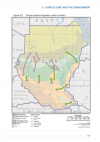
Depending on the criteria used these are the geographical centers of Africa. Between points 1,3 and 4 lies the land between the Uelé and Mbomu rivers. One of the main reasons civilization didn't develop inside the congo rainforest is that the soils are infertile and can't sustain high population densities.

Well this particular area has fertile nitisols perfect for growing crops like plantain and yam. Two of the tropical crops that can be harvested all year long thus allowing for huge population densities.
map6a~2.jpg

The dark areas represent the fertile soils of Africa, note the area circled in red.

It's central position would also allow the civilization to trade with 3 major river basins Lake Chad, the Nile and the Congo.
32243050331_eee96e4981_b~2.jpg
Allowing it's people to trade with the civilizations of the Horn, West Africa, the Nile, Lake Chad and later on the Congo.

In the OTL some of the ancestors of the present day inhabitants of this area might have been the first users of iron and made the bouar megaliths. They migrated from the west of the Central African Republic. https://www.researchgate.net/public..._of_African_Metallurgies_Summary_and_Keywords

In regards to resources the area has vast supplies of diamond, gold, ivory, furs and even a domesticable silk moth.

What are some other surprisingly great locations for a civilization that didn't have one?
 
The Mekong delta wasn't fully developed into a major living area until the Vietnamese started to developed it in the 16th century. Also I wonder why the Mississippi delta and river network didn't produce a unify and long lasting culture using the entire river network to make big long lasting civilization.
 
Also I wonder why the Mississippi delta and river network didn't produce a unify and long lasting culture using the entire river network to make big long lasting civilization.
To be fair, the Fertile Crescent region went through the same cycles of unity and splintering.
 
As I've written before, the Columbia Plateau of eastern Oregon/Washington/Idaho seems odd to have been so underdeveloped (even by the standards of North America) given the similarities to the Loess of China. It had salmon/trout resources that encouraged sedentary population even OTL and is also incredibly fertile assuming you can get water to it. It is located fairly close to all sorts of diverse environments ranging from the true desert to temperate rainforests which gives a diversity of resources and encourages trade. It seems like a natural area in which either a "hydraulic despotism" type of civilisation would have arose, or perhaps something along the more cooperative lines of Oasisamerican civilisation with the focus on irrigation and flood control.

I believe the reason why is that maize agriculture proved too challenging to adapt to the area. In Idaho it seems sporadically experimented with (perhaps introduced by trade with the Fremont culture of Utah), but the summers in the inland Northwest are too dry even compared to places like Arizona and irrigation/dam building too much of a hurdle to introduce (and the Fremont were pretty small-scale at that compared to the more classical Puebloans to their south). That said, native domesticates might be possible given how humans played a role in transplating both camas and the local species of oak and how the area is the center of biological diversity for the biscuitroots (Lomatium, many species of which served as food or medicine)

As for trade, before a major landslide around 1450 formed the rapids in the Columbia Gorge (now submerged by Lake Bonneville), it was possible to sail from the Pacific to Celilo Falls, which permits very long distance trade. This suggests the western side of the Cascades would probably be part of the same civilisation complex, probably with offshoots arising in the "classic" Northwest Coast area (Haida Gwaii/southern Alaska/adjacent coastal parts of BC), the interior plateaus of British Columbia (different climate, much colder, so might be a rather separate civilisation), and southern Oregon/northern California.
The Mekong delta wasn't fully developed into a major living area until the Vietnamese started to developed it in the 16th century. Also I wonder why the Mississippi delta and river network didn't produce a unify and long lasting culture using the entire river network to make big long lasting civilization.
Because the Mississippi River flows over a hugely diverse set of landscapes that range from semi-tropical marshes to frigid taiga, to say nothing of its tributaries which include stretches over arid plains and the infertile karstic landscape of the Cumberland Plateau. It also technically was a cradle of civilisation given the widespread interaction spheres of the Hopewellian and Mississippian cultures and the fact it even produced its own agricultural package (the most notable of which are sunflowers).
 
Problem: absolutely evil disease burden.
True but this is less of an issue in the rainforest savanna mozaic of the area compared to the inner Congo basin. Most settlements in Central Africa were originally also on hill tops. This would have further eased the disease burden.
 
True but this is less of an issue in the rainforest savanna mozaic of the area compared to the inner Congo basin. Most settlements in Central Africa were originally also on hill tops. This would have further eased the disease burden.
I actually think hilltop settlements are part of the problem (not the disease problem). Infant civilizations need to get dense, and carrying all your water up the hill is an impediment to that until relatively advanced technology.

Is your thesis that (ATL) agriculture develops independently there, or an independent civilization starts there, or that some threshold of development occurs there?
 
The American Mississippi basin.
What about all the mounds up and down it (the vast majority destroyed and a few in state parks) all over the Mississippi basin. Cahokia had around 10 to 15k at it's height, plus tributaries up and down the Mississippi. Most of Modern St. Louis is built on mounds of secondary cities.
 
What about all the mounds up and down it (the vast majority destroyed and a few in state parks) all over the Mississippi basin. Cahokia had around 10 to 15k at it's height, plus tributaries up and down the Mississippi. Most of Modern St. Louis is built on mounds of secondary cities.

Thing is, as impressive as Cahokia was, the area had the potential to be much more than that; as in, a cradle of civilization rivaling not only the Andes and Mesoamerica, but the river valleys of the Old World, too. The materials and resources needed for such a feat were more spread out in North America than elsewhere, but the gap could've easily been closed by a wider assortment of available crops and beasts of burden.

I think there used to be a TL around here, in which a civilization developed in the Mississippi river basin that was as hegemonic in North America as China was in East Asia, and that was able to deal with 16th century European powers on more or less equal footing.
 
I think there used to be a TL around here, in which a civilization developed in the Mississippi river basin that was as hegemonic in North America as China was in East Asia, and that was able to deal with 16th century European powers on more or less equal footing.
I’ve you, sir - it seems to be on hiatus and about the Illinois Confederacy’s ancestors more or less pulling off a Huaxia-become-Han/China situation.

 
limited access to other civilisations and cultures, it is an isolated region and also does not have coastal access being located that far inland.
 
South America is funny, civilization begun in the Andes region, a high plateau hard for human life, and not in the La Plata basin, the most fertile land of the continent
 
Regarding the OP's suggestion, I think @D'arguini may be overestimating the potential for trade routes out of the NE Congo. While it is close to the Nile watershed. the shortest route to the Nile hits the river south of the Sudd swamps, a barrier to navigation that blocked exploration, never mind trade, into the 20th Century. North-west you can get to the Chari and thence to Lake Chad, but getting further into West Africa is tricky because Lake Chad is an endorheic basin that doesn't connect to anything else. The fertile area also appears to be rather small, and surrounded by a large expanse of much less suitable terrain.

To answer the OP's question, I'll toss in the Danube, specifically the Lower Danube valley from the Iron Gates to the Black Sea. It's one of the few expanses of good flat land in Europe south of the Carpathians, and unlike the Pannonian plain upstream is readily accessible from the Black Sea. It can support a dense population - and did, as early as the Mesolithic - and there's the potential for the Danube to be the great trade/cultural artery linking the ancient Near East to Central Europe. Yet not only did the Danube not produce a civilisation of its own, it never amounted to much of anything for the whole of antiquity. The Greeks, for example, preferred to sail all the way to Italy or the Sea of Azov rather than settle the river valley just north of Thrace.
 

octoberman

Banned
It is not as fertile as the Bronze age Mesopotamia ,Egypt or Indus Valley and teste fly decimates cattle populations which crucial for civilization. Congo is not good for transport cause it take a full U turn unlike mostly linear paths of tigris,euphraytes,nile or the indus
 
I'm very happy this thread is getting attention. I do want to state that I don't mean this particular area is going to rival the Yangtze river basin. But I think it's a relatively good location in Africa that surprisingly didn't really have a notable civilization or kingdom up to the modern era.
5c783270d2874af4053f620c7c20bd5c.jpg

The first kingdoms in the Congo basin arose around the Kwango river and the Upemba Depression. Their isolation did not stop them from developing relatively developed unique cultures. The place where the Luba kingdoms arose, the Upemba Depression for example is incredibly isolated. But still spread it's culture from the Congo basin to the Zambezi river. While an area with acces to trade around Lake Chad, the Nile and some of the only fertile soil in the area has nothing for thousands of years? I just thought it was curious.

I actually think hilltop settlements are part of the problem (not the disease problem). Infant civilizations need to get dense, and carrying all your water up the hill is an impediment to that until relatively advanced technology.

Is your thesis that (ATL) agriculture develops independently there, or an independent civilization starts there, or that some threshold of development occurs there?
Hmm that's interesting but, how big of an problem would this be? Some of the most densely populated areas in Africa are in hilly land or highlands. The area was populated by farmers around 3000-2000 BC. These would have already had yam, pearl millet, hausa potatoes and latter the Bantu would bring plantains. I think an connection between these people and those of upper Nubia would have been possible. And could have provided the spark of civilization. We know Nubia traded at least as far as southwestern Sudan and South Sudan.
Regarding the OP's suggestion, I think @D'arguini may be overestimating the potential for trade routes out of the NE Congo. While it is close to the Nile watershed. the shortest route to the Nile hits the river south of the Sudd swamps, a barrier to navigation that blocked exploration, never mind trade, into the 20th Century. North-west you can get to the Chari and thence to Lake Chad, but getting further into West Africa is tricky because Lake Chad is an endorheic basin that doesn't connect to anything else. The fertile area also appears to be rather small, and surrounded by a large expanse of much less suitable terrain.

To answer the OP's question, I'll toss in the Danube, specifically the Lower Danube valley from the Iron Gates to the Black Sea. It's one of the few expanses of good flat land in Europe south of the Carpathians, and unlike the Pannonian plain upstream is readily accessible from the Black Sea. It can support a dense population - and did, as early as the Mesolithic - and there's the potential for the Danube to be the great trade/cultural artery linking the ancient Near East to Central Europe. Yet not only did the Danube not produce a civilisation of its own, it never amounted to much of anything for the whole of antiquity. The Greeks, for example, preferred to sail all the way to Italy or the Sea of Azov rather than settle the river valley just north of Thrace.
The Sudd is indeed a great barrier for river transport. But we shouldn't confuse Africa for Europe or Asia. My point wasn't that they could sail to the Mediterranean. Most African rivers are not navigable for their entire length.
2_SUDAN_basins-map_1024px.png

If our imaginary traders reach the Bahr El Arab. They can trade their wares with the nomads of Darfur and Kordofan. These herders seasonally migrate between this river, the wadis of Western Sudan and the main stream of the Nile. And they've done this since the desertification of the Sahara thousands of years ago.

It's true Lake Chad is an endoreic basin but when you've reached Lake Chad you're basically already in West Africa. You can reach Hausaland directly from Lake Chad. And from there the vast trading networks of West Africa.
lake-chad-basin.jpg


The area has major issues but most inland kingdoms in Africa had those. The sheer emptiness of this particular area even when the conditions aren't particularly terrible. Is what's puzzling to me.
 

Attachments

  • 43b513f2-1252-30e0-9892-770d495a77be.png
    43b513f2-1252-30e0-9892-770d495a77be.png
    110.3 KB · Views: 114

Coivara

Banned
Amazon River Delta. Big floodlands in the Marajó and such. Not that much fertile for agriculture but there's a looooot of navigable river land and easy access to the coast as well. They would have contacts ranging from Peruvian highlands (Incas) to Amazonian Chiefdoms to contact with groups all along the coasts of eastern South America and even Caribbean and Mesoamerica.

I mean, technically it happened, the Marajoaras were a thing after all. We have no idea how big their civilization was because it collapsed shortly before the Portuguese arrived (Arawak invasion AFAIK) and they didn't use materials good for preservation, but AFAIK estimates are for 100k Marajoarans at least.
 
The Ukraine was one of the main grain-producing regions of Europe during classical antiquity and from the nineteenth century onwards, but, with the exception of Kievan Rus', it's spent most of its history either inhabited by nomads or else a border region disputed by other powers.
 
The Ukraine was one of the main grain-producing regions of Europe during classical antiquity and from the nineteenth century onwards, but, with the exception of Kievan Rus', it's spent most of its history either inhabited by nomads or else a border region disputed by other powers.

Being completely flat land with no natural defenses tends to do that; that said, you could've had the Cucuteni-Trypillia culture develop a civilization strong enough to either assimilate the Indo-European horse nomads (example: every conqueror of China and Persia), or just massively influence said Indo-European horse nomads before disappearing (example: Etruria's influence on Rome, the Toltec influence on subsequent Mesoamerican civilizations).
 
Top