You are using an out of date browser. It may not display this or other websites correctly.
You should upgrade or use an alternative browser.
You should upgrade or use an alternative browser.
Return of Horrible Educational Maps
- Thread starter Westphalian
- Start date
They were obscured by the "fog of war", I suppose 🤣Nobody noticed the two crimeas?
Crazy Boris
Banned
well, that's one way to solve the crisisNobody noticed the two crimeas?
Russia gets one, Ukraine gets one, everyone's happy
Romanian TransDniester in 1914...
Always thought what the Austro-Hungarian Empire needed was some Bulgarians

Hey, the more ethnic groups, the merrier, right? 🤔

At first I thought it was cool how the transparent globe emphasized how big the Pacific Ocean was. Then I realized it was because Alaska and Siberia were thousands of miles apart. On a globe…
Speaking of maps pretending to be a globe:
With an equator that runs through Havana. And what the *bleep* did they do the Antarctica.
There are several good projections for portraying one hemisphere within a circle.... this... whatever it is
, is NOT one of them....I thought that was the Tropic of Cancer.With an equator that runs through Havana.
Count the lines of latitude. The equator isn't shown as a line. It would run roughly from Los Angeles to Cape Hatteras.With an equator that runs through Havana. And what the *bleep* did they do the Antarctica.
Oh nice, the equator goes almost straight through the Gibraltar Strait. Also, "Western Sharah" and a tiny island in the Atlantic called Liechtenstein. And, while I would call any modern use of Mercator projection horrible, overlaying it on a globe is a special crime.Count the lines of latitude. The equator isn't shown as a line. It would run roughly from Los Angeles to Cape Hatteras.
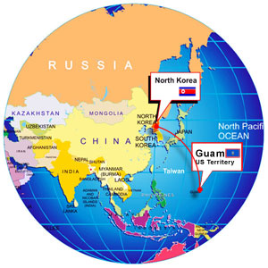
But that whole site is a collection of horrible maps, including this ugly equal-area projection, "updated last 2017", but where's South Sudan and Kosovo? The link to a map to "help to educate children and other corporate people" is unfortunately dead, but there's still this "North Kore Location map and Guam location map on globe":
Crazy Boris
Banned
Ah yes, the Territery of Guam. Important to note that it’s a territery and not a stote.Oh nice, the equator goes almost straight through the Gibraltar Strait. Also, "Western Sharah" and a tiny island in the Atlantic called Liechtenstein. And, while I would call any modern use of Mercator projection horrible, overlaying it on a globe is a special crime.
But that whole site is a collection of horrible maps, including this ugly equal-area projection, "updated last 2017", but where's South Sudan and Kosovo? The link to a map to "help to educate children and other corporate people" is unfortunately dead, but there's still this "North Kore Location map and Guam location map on globe":
Almost every single interwar textbook i have had has "East Prussia" labeled as a separate entity rather than a German Exclave
that might be dependent on how the maps are being portrayed--are they in full color, or just outlines? (this was the only real problem i had with the selective representation on UCS, since it could make a non-contiguous country which didn't have a color look like it represented more countries than actually exist)Almost every single interwar textbook i have had has "East Prussia" labeled as a separate entity rather than a German Exclave
Crazy Boris
Banned
Almost every single interwar textbook i have had has "East Prussia" labeled as a separate entity rather than a German Exclave
I remember when I was younger and just starting learning about history I assumed East Prussia had to be a country at some point because I’d heard it referred to as if it was one before. I can’t remember exactly what I thought, like, when it would have been or under what circumstances it would be separated from West Prussia, but it made sense to me
I remember when I was younger and just starting learning about history I assumed East Prussia had to be a country at some point because I’d heard it referred to as if it was one before. I can’t remember exactly what I thought, like, when it would have been or under what circumstances it would be separated from West Prussia, but it made sense to me
East Prussia was a country at some point (Duchy of Prussia). It was separated from West Prussia because Polish Kings took over that.
Crazy Boris
Banned
Fair point, but my younger self was thinking about the 1800s and 1900sEast Prussia was a country at some point (Duchy of Prussia). It was separated from West Prussia because Polish Kings took over that.
Share: