You are using an out of date browser. It may not display this or other websites correctly.
You should upgrade or use an alternative browser.
You should upgrade or use an alternative browser.
Largest Possible Canada
- Thread starter InvaderX
- Start date
If the British win the war of 1812, New England could secede as a British Protectorate and the Brits themselves keep some or all of Louisiana. Then an ALT civil war might see the north secede from the slave states. These states may then also join up for protection. If this ALT has British settlers in the place of American ones in Texas and California, they could also be on the table for joining.
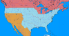
This ALT Canada could hold all of OTL Canada and USA except for the areas east of the Mississippi, the east coast from Maryland to Florida.
Probably not very likely though
This ALT Canada could hold all of OTL Canada and USA except for the areas east of the Mississippi, the east coast from Maryland to Florida.
Probably not very likely though
I doubt a secessionist North would join Canada, and if it did, then that would dramatically shift the balance of demographics and power to the former US - it would pretty much just be America with Canada and without the South.If the British win the war of 1812, New England could secede as a British Protectorate and the Brits themselves keep some or all of Louisiana. Then an ALT civil war might see the north secede from the slave states. These states may then also join up for protection. If this ALT has British settlers in the place of American ones in Texas and California, they could also be on the table for joining.
This ALT Canada could hold all of OTL Canada and USA except for the areas east of the Mississippi, the east coast from Maryland to Florida.
Probably not very likely though
Deleted member 109224
The question is at what point does Canada become so big and end up so full of people who weren't canadian OTL (and, for that matter, are culturally distinct from those who became Canadian OTL) that it no longer is Canada? At what point is Canada so large that Canadian history as we know it doesn't occur?
If you look at when US states were admitted OTL, then it's hard to get the impression that a 46th or even 42nd parallel boundary would be an issue. Oregon only had one house member until 1890. Washington, Montana, Dakotas, and Wyoming weren't admitted until 1889/1890.

A boundary like this works well, I think. The major western trails (Oregon Trail, California Trail, Mormon Trail, and Santa Fe Trail) remain in the US. Washington, Montana, Wyoming, Dakotas weren't admitted as states until ~1890 so there shouldn't be issues of Americans moving in and pulling a Texas. The Upper Midwest wasn't admitted until the late 1840s too, with the exception of Michigan. Illinois and Indiana were primarily settled in the south first. Meanwhile the folks who settled the Upper Midwest were primarily Yankee, much like the folks who tended to move into Upper Canada OTL.


If you look at when US states were admitted OTL, then it's hard to get the impression that a 46th or even 42nd parallel boundary would be an issue. Oregon only had one house member until 1890. Washington, Montana, Dakotas, and Wyoming weren't admitted until 1889/1890.
A boundary like this works well, I think. The major western trails (Oregon Trail, California Trail, Mormon Trail, and Santa Fe Trail) remain in the US. Washington, Montana, Wyoming, Dakotas weren't admitted as states until ~1890 so there shouldn't be issues of Americans moving in and pulling a Texas. The Upper Midwest wasn't admitted until the late 1840s too, with the exception of Michigan. Illinois and Indiana were primarily settled in the south first. Meanwhile the folks who settled the Upper Midwest were primarily Yankee, much like the folks who tended to move into Upper Canada OTL.
I rather like the originality of this map that I found online.
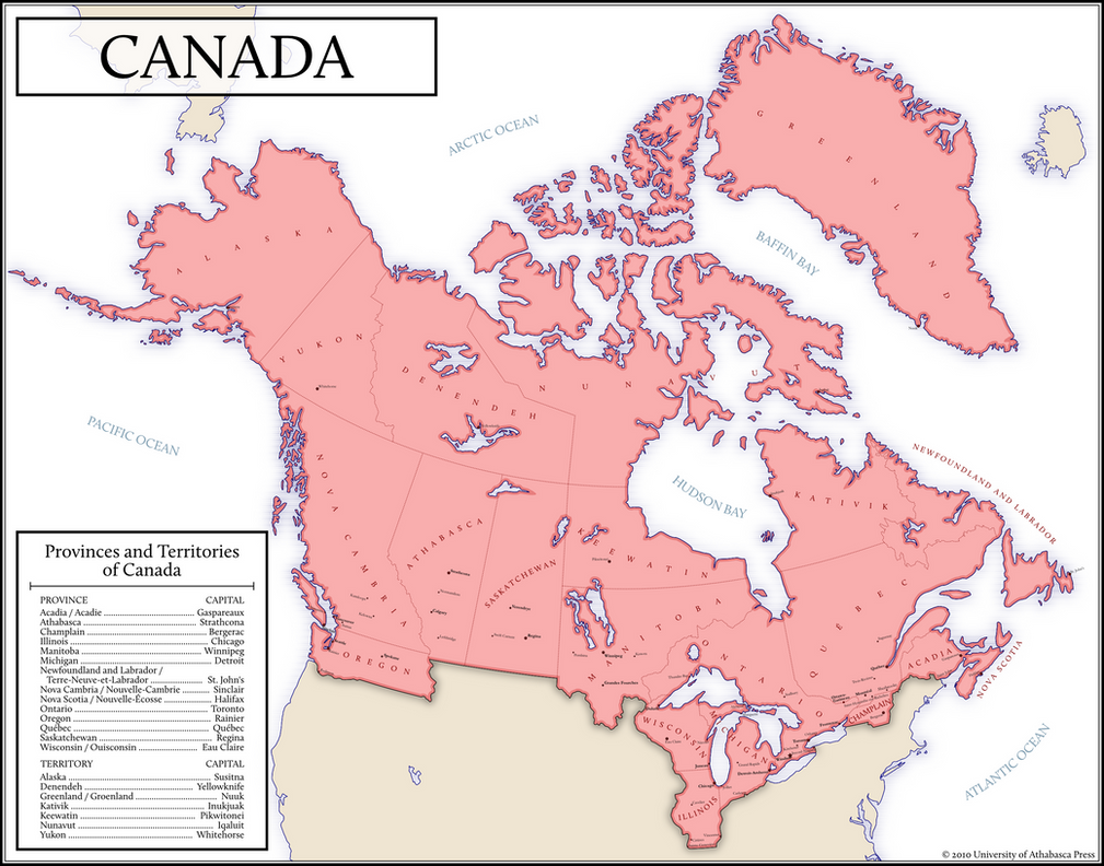
While I do agree something bigger is possible, I really like this. It comes fairly close to what's in my head as likely, though I tned to think Illinois is pushing matters. I'm inclined to picture my "bigger but plausible" Canada as having Alaska, all of Oregon North and West of the Columbia, keeping the Red River Colony, getting a Maine border much like the above and while not getting Wisconsin Michigan and Illinois drawing a line around the 46th parrallel (I have a hard time picturing a border south of Green Bay, and the combination that I like aesthetically is the one that makes Minneapolis and St. Paul border towns with the boundary down the middle of the river) in that puts the head of Mississpi navigation in Canada (and including some kind of navigation rights).
I'll add that while these don't wipe out Canadian history as we know it, anything that puts the Upper Peninsula in Canada is going to have some interesting butterflies that could get fairly large. Even as things were there were games played about whether taking a railroad north of Superior was worthwhile - if you put the alternate routes in Canada it's a non-starter and I very much doubt you'd see any railroad through the shield until the National Transcontinental (not finished until WWI had already started) and I have my doubt's there would be a significant highway up there even now.[/QUOTE]
British go slightly power hungry in Napoleonic Wars and grab Greenland from Denmark-Norway.
British defeat the Russians slightly worse in Crimean War, seize Alaska.
Canada becomes even larger, with a significantly larger resource base and area, but not a significantly larger population. While these frozen landscapes garner little interest at the time, the '70s spike in oil prices turns Alaska - already a literal goldmine - into a metaphorical goldmine. During the early '00s oil boom, prospectors discover the (as-yet-unrecovered ITTL) massive submarine oil deposits in Greenland, turning it into a virtual energy El Dorado. By the late 20th century, when technology enables mineral and energy recovery on a massive scale from inhospitable climates, the combination of Alaskan, Canadian, and mineral resources has caused wages and immigration to rise due to high demand for labor. The economy economy explodes during the oughts, turning it into a North American Switzerland in terms of per capita wealth, with a diversified economy and highly educated populace keeping the worse symptoms of Dutch Disease at bay.
(AKA Diet-Canada Wank)
unprincipled peter
Donor
there's evidence that Britain was prepared to give up far more in the negotiations, but the US sent the B negotiators. I get the feeling either side could have gotten more out of the deal in the NW.Apparently Michigan was supposed to go to the British after the end of the revolutionary war, but Britain sent its B team negotiators.
Canada is (or at least is supposed to be) as much a state of mind as it is a state. As long as we get them early enough, even Mexico and Dixie can be a grumbling grudging part of Confederation the way Quebec is. If anything, the larger and more diverse Canada is the more stable it is.
It is all well and good to propose scenarios with a larger British North America. I can easily imagine a scenario where the British seize what we know as the Midwest, the Pacific Northwest, the Louisiana Purchase, Alaska, and parts of New England. Heck, if you can get that far, I can buy that they would go for California, New Mexico, and Texas as well.
The problem is... well, once independence is achieved, is this country recognizable as Canada, or is the land that comprises Canada in our timeline ironically a largely peripheral area of a continent-spanning empire with its population and political, industrial, and economic power based elsewhere? In that case, you may as well have the United States annex Canada and say that this counts as greater Canada.
In my opinion, the largest that Canada can get while still remaining recognizably Canadian by our timeline’s standards would amount to an addition of Alaska, Maine, the Pacific Northwest, and the northern portion of the Midwest - roughly the Dakotas, Minnesota, Wisconsin, and part of Michigan.
EDIT: I see that @Jackson Lennock already covered much of what I wrote.
I rather like the originality of this map that I found online.
I love these maps, there's just one thing.
I find it funny that they change borders and names within Canada so much yet the borders and names of Michigan, Illinois and Wisconsin are extremely similar to OTL (i'm looking at you upper peninsula), especially considering that the borders are the result of some pretty specific and far from guaranteed events. Depends on the POD though.
Share: