That's better.https://mega.nz/#F!wYJQGLwL!gx0thpVFzQZb8YJ4CqKqMA
This should be more permanent.
I hope there is not rule against posting mega links here. I've looked at the forum rules and couldn't find anything that prohibits it. If so I'm sorry, I'll go on to delete this post.
You are using an out of date browser. It may not display this or other websites correctly.
You should upgrade or use an alternative browser.
You should upgrade or use an alternative browser.
A Blank Map Thread
- Thread starter Matt
- Start date
FantasyMapper7806
Banned
If I remember correctly the map is part of a DH mod so Antarctica and northern America and Siberia aren't included on the maps.
You can find paradox maps that include these parts on moxns deviantart so maybe you could overlay them: https://moxn.deviantart.com/art/Blank-World-Map-Borderless-565414843
Africa: https://filetea.me/n3wAxZDYddtQoC2liuacGB6xw
Asia: https://filetea.me/n3wmpWv6GXAQvCTJ58Z4xtAEw
Europe: https://filetea.me/n3wmT9PbW1OQ8C8pO4uQXHxWQ
North America: https://filetea.me/n3w3xiPkdMyTkxFZKQfDUxAAA
Oceania1: https://filetea.me/n3wv23OkGnPQIOUABqfbxdSbA
Oceania2: https://filetea.me/n3whc3ixC3KSGaFIo1GsZMhNg
South America: https://filetea.me/n3wa8azKUQ3TQGsyi8ahDZgrA
World: https://filetea.me/n3wUKV6xwQkQdmzs6phRFoeFg
If these links don't work I'll try uploading them somewhere else.
Unfortunately, these links don't work for me. Could you split up the Africa one and post it on Imgur please?
Unfortunately, these links don't work for me. Could you split up the Africa one and post it on Imgur please?
https://mega.nz/#F!wYJQGLwL!gx0thpVFzQZb8YJ4CqKqMA
This should be more permanent.
I hope there is not rule against posting mega links here. I've looked at the forum rules and couldn't find anything that prohibits it. If so I'm sorry, I'll go on to delete this post.
Does this one work?
Only the preview is fuzzy because the image is too large. Once you download them they should be fineIt does, but everything is like, fuzzy.
FantasyMapper7806
Banned
Only the preview is fuzzy because the image is too large. Once you download them they should be fine
Ok!
I know it's not blank map but i need historical/old map of Poland, Ukraine (with Crimea), Belarus and Baltics. Between Brest-Livotsk and 1938. Preferably high resolution
@TimTurner I rather like the map, but no, it won't work. Although, I have a different project I may be able to use your map for. But I want the borders to be drawn on my map specifically. (If I just needed any old world map with US, Canadian, and Australian states, there are others on this thread.) I want it on that map because (among many other reasons) it has borders more than one pixel thick, which allows me (and my terrible Photoshop skills) to create a good map. BTW, if someone does decide to draw in the states on that map, please make the borders 2-3 pixels wide. thanks!
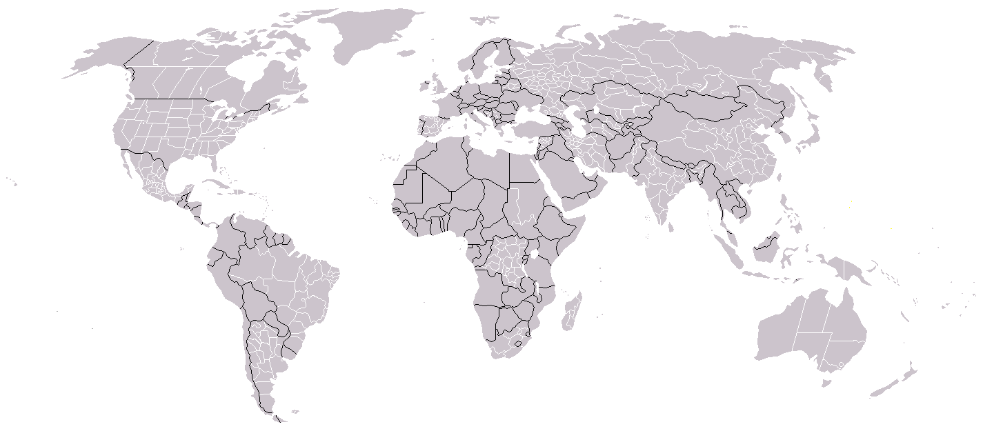
I like maps, and flags. But I am TERRIBLE at editing them. (It doesn't help that I have only MS Paint.) So, I am going to throw myself on the kindness of the internet. Would someone please draw in the US, Canada, and Australia state borders on this map? Thanks if anyone does.
View attachment 362830
Maybe the standard Worlda is what you're looking for?
Here you have some more versions with different colors. Unfortunately I haven't found a plain grey like those on Wikipedia.
EDIT: WAIT I DID
And here are more.
Hope it helps!
I have a request: there was floating around there a map key for governments and ideologies (democracies, monarchies, theocracies, single-party states, etc.) Does anybody has it?
I have a request: there was floating around there a map key for governments and ideologies (democracies, monarchies, theocracies, single-party states, etc.) Does anybody has it?
Is this what you meant?
Is this what you meant?
Er, no, it was a key for all countries, not just individual cases (a single color for democracies, theocracies, etc.) It was in the form of a spectrum so to speak.
That is very interesting though, and might be useful, so thanks anyway!
like this map at the bottom of this wiki article?I have a request: there was floating around there a map key for governments and ideologies (democracies, monarchies, theocracies, single-party states, etc.) Does anybody has it?
https://en.wikipedia.org/wiki/Government
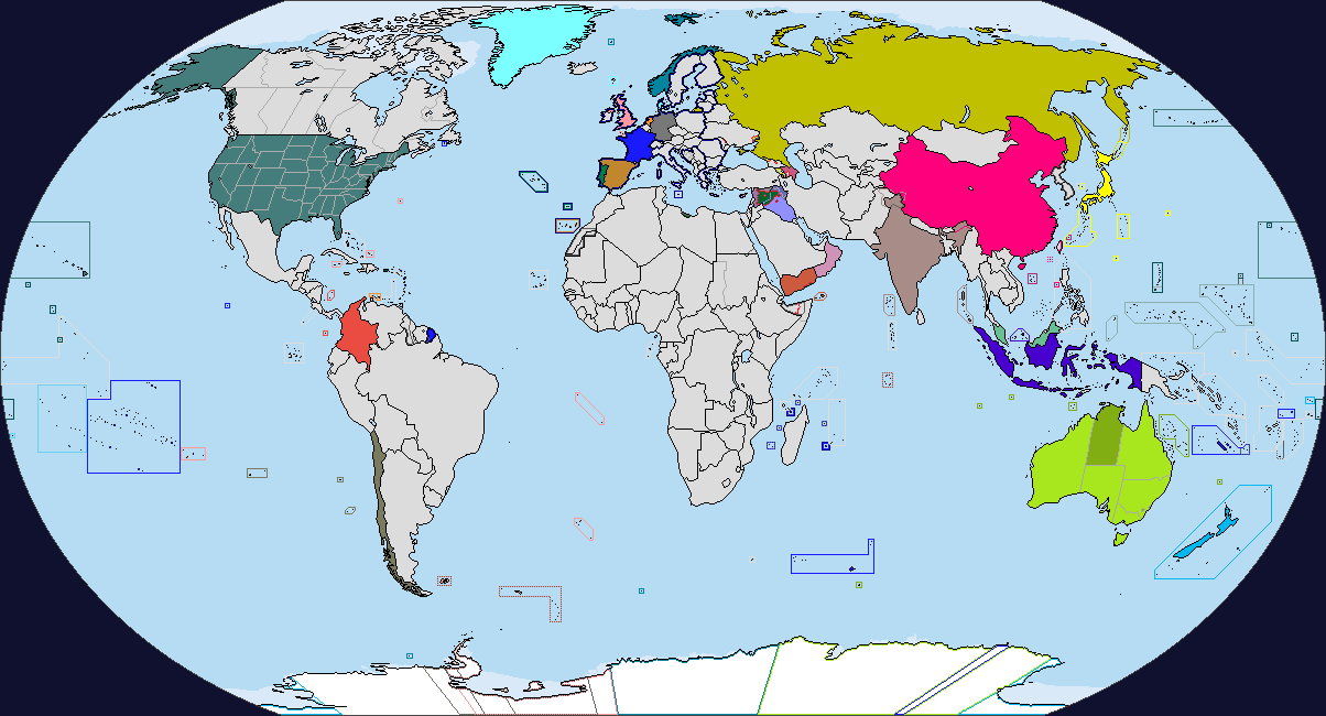
Basically, this is a world in which Talleyrand's plan of Belgian partition was realized, which significantly changed WWI as we know it. The year of the map is 1917, at the start of the Great War.
Last edited:
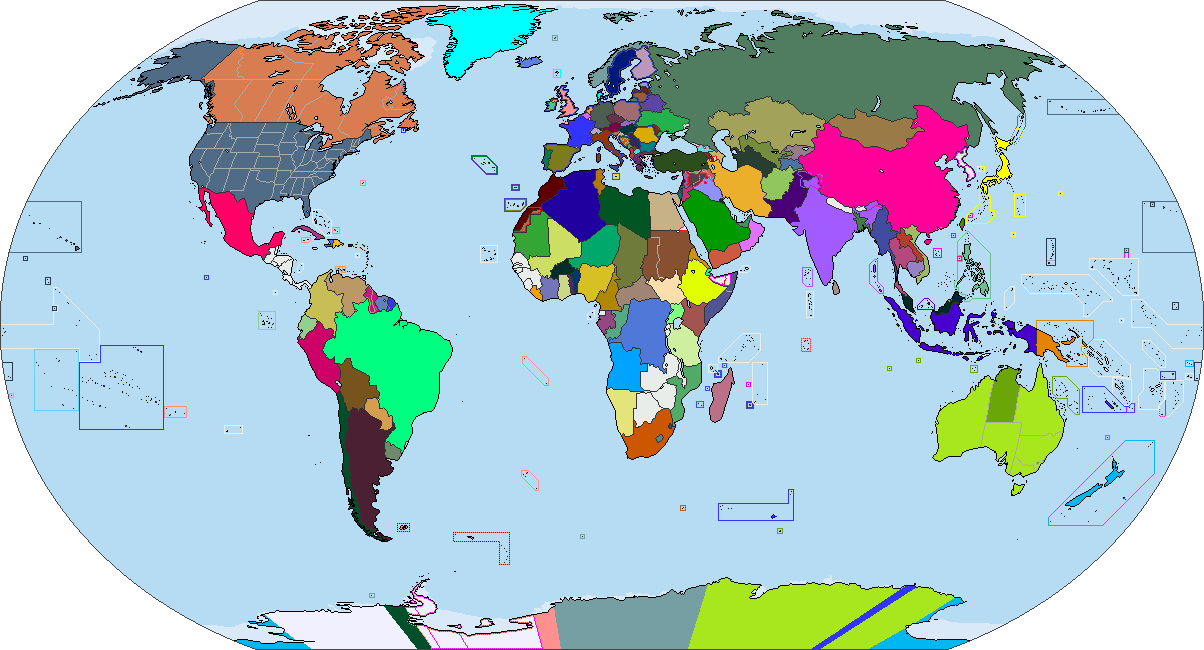
i like your map. just wondering what the history for the Congo region is? i also have wrote an alt-histroy without Belgium and the Congo region especially the eastern part is a bit difficult to decide which country would claim it.My first blank map after trying out @Zagan 's paint.net tutorial, will color it later. The base maps are from historicalmapchart.net
Basically, this is a world in which Talleyrand's plan of Belgian partition was realized, which significantly changed WWI as we know it. The year of the map is 1917, at the start of the Great War.
Share: