You are using an out of date browser. It may not display this or other websites correctly.
You should upgrade or use an alternative browser.
You should upgrade or use an alternative browser.
Map Thread XIII
- Thread starter Pragmatic Progressive
- Start date
- Status
- Not open for further replies.
Dorozhand
Banned
Map of the State of Nuevo Mexico with municipalities and larger cities denoted. After Mexico's victory in the Mexican-American War (1851-1853), the northern territories experienced massive population growth following the payment of soldiers in land grants and the encouragement of migration from the poorer southern states. Jose Antonio de Zapata's Great Northern Expedition during the Mexican Civil War (1842-1846) against the Comanche, which resulted in their total defeat and subjugation, also contributed to this growth.
Four years after the end of the Mexican-American War, in which Nuevo Mexico experienced a large amount of fighting and great mineral riches and migrations resulted in population growth, president Juan Alvarez authorized the admission of the territory as a free and sovereign state. Railroad connections from Santa Fe and Taos to the south resulted in closer connection between Nuevo Mexico and the south and the state continued to grow in prosperity and population. Today it is a centre of Mexico's film industry and a major producer of raw materials and electronics.


Four years after the end of the Mexican-American War, in which Nuevo Mexico experienced a large amount of fighting and great mineral riches and migrations resulted in population growth, president Juan Alvarez authorized the admission of the territory as a free and sovereign state. Railroad connections from Santa Fe and Taos to the south resulted in closer connection between Nuevo Mexico and the south and the state continued to grow in prosperity and population. Today it is a centre of Mexico's film industry and a major producer of raw materials and electronics.
Current map for the map game "Silent Reverse Mapgame ~Historiae mutetur!~" by Lascupa0788 et. al. (this map is the year 1360)
When would be your first POD?
When would be your first POD?
2013, it goes in reverse. https://www.alternatehistory.com/discussion/showthread.php?t=298392
When would be your first POD?
What empty said, 2013 is the point of convergence. Players work backwards, to make an ATL that converges to make the current year of OTL (at the time, that year was 2013). It's almost -700 years running, right now.
"Velvet" what?!
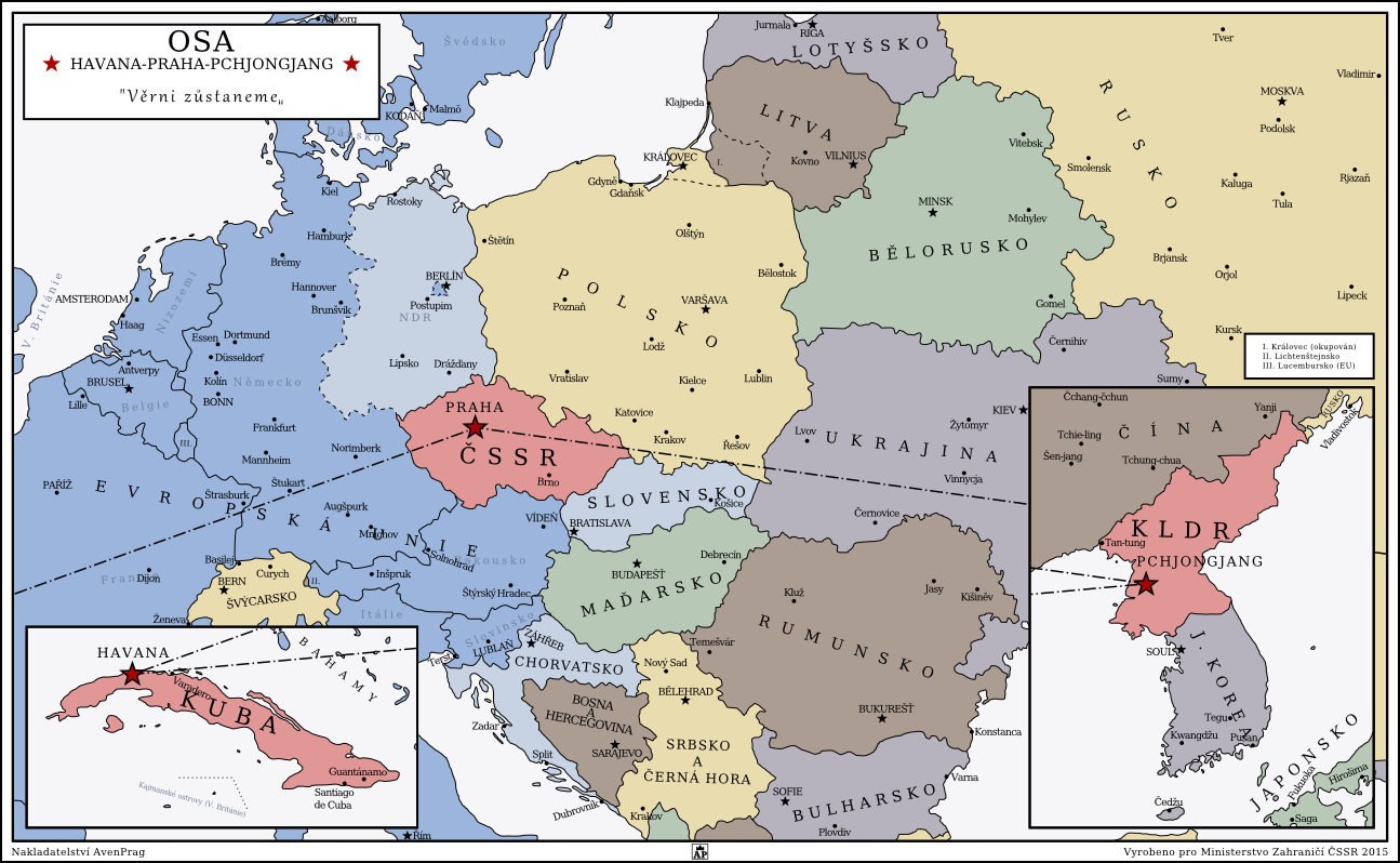
“Velvet” What?!
Or at least that’s what I imagine the reaction of somebody from the above timeline to hearing of the Velvet revolution would be. In this timeline, there was no Velvet revolution. During the breakup of the communist regimes, the communists in Prague managed to hold on to power. The less left-oriented Slovaks didn’t take well to this and a brief power struggle later, they declared independence. The Czechoslovak communist party had their hands full putting down uprisings in Czechia to do much about Slovakia and thus the Slovak Republic and Czech Soviet Socialist Republic were born.
It is now 2015 and east Europe is slowly turning west. Poland and Lithuania divided Kaliningrad among themselves after the dissolution of the USSR. Due to their conflict over it with Russia, EU’s expansion into east Europe has slowed. Meanwhile the peacefully-dissolved ex-Yugoslav states have a much better chance of joining the Union (Slovenia has already joined, Croatia is in the process of joining). The East German Republic didn’t see the quick fall of the Berlin wall and is instead slowly coordinating unification with west Germany and thus also the EU. Almost as if trying to prove something to their red western neighbors, the Slovaks have been riding a pro-western wave these past twenty years and with American support boast an impressive and modern army (mainly stationed on the western border with CSSR) and are on their way into the EU.
The Czechs, sourly watching the former Soviet empire collapse, crawl back into a North-Korean-esque shell from the rest of Europe. Instead, they seek closer ties with other “leftover” communist states, North Korea and Cuba. Banding together, they sign the treaty of Havana and create a cooperative “axis”. Most of the rest of the world is rather amused by these little pipsqueaks, feeling only slight distaste at their used of the name “Axis” for their alliance. How amused will they be when they find out that the three reds have been fast at work at building their own nuclear arsenal, based on reverse-engineered Soviet rockets left behind in their old bunkers in Czechia?
The header of the map says “Axis Havana-Prague-Pyongyang” and “We shall stay loyal”, a motto often used throughout Czechoslovak history.
I originally intended to post this on the 17th, the anniversery of the revolution, but school, work and generally life-issues didn’t allow me to finish it till today. So I hope you enjoy it")
If you share, please credit me by linking back to the page below
http://soaringaven.tumblr.com/post/133750971782/velvet-what-or-at-least-thats-what-i-imagine
“Velvet” What?!
Or at least that’s what I imagine the reaction of somebody from the above timeline to hearing of the Velvet revolution would be. In this timeline, there was no Velvet revolution. During the breakup of the communist regimes, the communists in Prague managed to hold on to power. The less left-oriented Slovaks didn’t take well to this and a brief power struggle later, they declared independence. The Czechoslovak communist party had their hands full putting down uprisings in Czechia to do much about Slovakia and thus the Slovak Republic and Czech Soviet Socialist Republic were born.
It is now 2015 and east Europe is slowly turning west. Poland and Lithuania divided Kaliningrad among themselves after the dissolution of the USSR. Due to their conflict over it with Russia, EU’s expansion into east Europe has slowed. Meanwhile the peacefully-dissolved ex-Yugoslav states have a much better chance of joining the Union (Slovenia has already joined, Croatia is in the process of joining). The East German Republic didn’t see the quick fall of the Berlin wall and is instead slowly coordinating unification with west Germany and thus also the EU. Almost as if trying to prove something to their red western neighbors, the Slovaks have been riding a pro-western wave these past twenty years and with American support boast an impressive and modern army (mainly stationed on the western border with CSSR) and are on their way into the EU.
The Czechs, sourly watching the former Soviet empire collapse, crawl back into a North-Korean-esque shell from the rest of Europe. Instead, they seek closer ties with other “leftover” communist states, North Korea and Cuba. Banding together, they sign the treaty of Havana and create a cooperative “axis”. Most of the rest of the world is rather amused by these little pipsqueaks, feeling only slight distaste at their used of the name “Axis” for their alliance. How amused will they be when they find out that the three reds have been fast at work at building their own nuclear arsenal, based on reverse-engineered Soviet rockets left behind in their old bunkers in Czechia?
The header of the map says “Axis Havana-Prague-Pyongyang” and “We shall stay loyal”, a motto often used throughout Czechoslovak history.
I originally intended to post this on the 17th, the anniversery of the revolution, but school, work and generally life-issues didn’t allow me to finish it till today. So I hope you enjoy it
If you share, please credit me by linking back to the page below
http://soaringaven.tumblr.com/post/133750971782/velvet-what-or-at-least-thats-what-i-imagine
Yes.... I don't see Jefferson being used as a state name these days, especially as the cities of northern California would frown about Jefferson's hypocrisy and his spirited defense of slavery. I suppose it was all just a way to keep the Senate a little more fair? And looking at the borders of the northern state, I imagine Sierra or Nevada might be a good name.
I hate to nitpick this with you, but no, despite his contradictions, Jefferson was *not* actually a spirited defender of slavery; in fact, even in his later years, he remained staunchly opposed to slavery expanding any further from where it had already existed(and for that matter, would no doubt have been disgusted by Calhoun and the Fire Eaters had he lived longer).
With that said, though, Sierra would be a
Map of the State of Nuevo Mexico with municipalities and larger cities denoted. After Mexico's victory in the Mexican-American War (1851-1853), the northern territories experienced massive population growth following the payment of soldiers in land grants and the encouragement of migration from the poorer southern states. Jose Antonio de Zapata's Great Northern Expedition during the Mexican Civil War (1842-1846) against the Comanche, which resulted in their total defeat and subjugation, also contributed to this growth.
Four years after the end of the Mexican-American War, in which Nuevo Mexico experienced a large amount of fighting and great mineral riches and migrations resulted in population growth, president Juan Alvarez authorized the admission of the territory as a free and sovereign state. Railroad connections from Santa Fe and Taos to the south resulted in closer connection between Nuevo Mexico and the south and the state continued to grow in prosperity and population. Today it is a centre of Mexico's film industry and a major producer of raw materials and electronics.
Nice map. Is this part of your Mexican TL, by any chance?
shiftygiant
Gone Fishin'
Thought I might as well post this here; my entry for the now over MotF.
~The United Commonwealth of Poland~

Map of the UCP at its height (1927-1960) superimposed on modern borders. Modern Poland is in Red.
The United Commonwealth of Poland, also known as the Second Commonwealth, or simply Poland, refers to the nation that existed between the Wars of Polish Reunification and the Second Partition (1924-1967). Founded in the initial aftermath of the First World War under the Wilson Agreement in 1918, following a series of intense regional conflicts, the planned borders far outgrew the original plan of the Polish Committee, expanding from Gdynia to Ryga to Odessa, the final borders decided following the Polish-Soviet War in 1927. Surrounded by Germany, Czechoslovakia, Austria (Until 1940), Rumania, The Soviet Union, The Kingdom of Königsberg (From 1942), and the Baltic Union (Until 1938), Poland saw a turbulent relationship with her neighbors, switching between alliances and antagonism, often alienating the state from the rest of Eastern Europe; from the end of the Polish-Soviet War to the Second Polish-Soviet War (1960), the UCP controlled a corridor of land that connected the state to the Black Sea. Despite ethnic tensions from it's diverse Ethno-Linguistic makeup, and pressures internal and external, the UCP was able to remain a dominant regional power for most her existence, often refereed to as the 'Second Golden Age' due to it's relative political and economic stability and technological progress. This would end with the Second Polish-Soviet War, which cut Poland from the Black Sea and crippled her accompany, and saw a fragmentation of Commonwealth society, accumulating in the Second Partition in 1967 by the League of Nations.
The UCP has been often refereed to as Switzerland of Eastern Europe- this grew from it's twenty-nine year long period of Armed Neutrality (1930-1959)*, as well as long lasting President Milo Jakubowicz's (1880-1956) emphasis on Banking, Trade, Social Democracy, and Public Works, hoping to make Poland the most modern state in Europe. Whilst it is generally agreed that this was, in a sense, accomplished, this came with disenfranchisement of Ukrainian, Byelorussian, and Russian minorities, as well as the controversial Language Laws, both often cited as the reason for the Commonwealths failure. The UCP was succeeded by the Third Polish Republic, with it's Eastern Frontier carved up between the Soviet Union and Königsberg. Today, the legacy of the UCP is physically visible, with it's roads and cities held as marvels of 20th Century Engineering, and a strong Polish Language Presence.
Since 1967, Poland has been in a state of constant Political flux, with the rise of the Far Right organisation Narodowe Odrodzenie (National Revival) through 70's and 80's, leading mass violence against ethnic minorities and homosexuals, as well as rioting against Liberal legislation, NO seeing ethnic diversity, the acceptance of Homosexual lifestyles, and general Liberalism as the causes for Poland's second partition. NO would gain ground in the Polish Elections, with their leader Alex Gmurczyk ascending to high office briefly in the Summer Election of 1988 after running an vigorous Anti-Communist, however would be removed by the Polish Army following his attempt to pass anti-Minority legislation. The Army, led by Wojciech Jaruzelski, took control of the nation, instituting Martial Law and banning Political Parties; this would result in the Polish Civil War, which saw the Army, NO, and Communists fight for domination. Following the dissolution of the Soviet Union in 1995, Germany and Czechoslovakia would lead a League of Nations intervention into Poland, annexing western regions in the process. With the League of Nations taking control of the nation, Poland was transitioned back into Democracy, however still suffers from Strong Man politics, high levels of Corruption, and rampant violence against minorities and homosexuals. Since 2006, Poland has been part of the Commonwealth League, however due to antagonism to Königsberg and Ukraine, has seen its membership threatened.
The UCP was a founding member of the ECC, with the Third Republic a having been a member of the ECC's successor, the European Community, since 1999.
*Also referred to as the Golden Age, it is worth noting that Poland did fight armed conflict during this period, namely in the Anglo/Franco-German War (1938-1943), however was itself third party to the events.
snip
Poor Czechs. Nice map, and an interesting idea. We need more post-cold-war scenarios.
Did Russia lose any more areas which it retained in OTL, or was it just Kaliningrad?
shiftygiant
Gone Fishin'
Poor Czechs. Nice map, and an interesting idea. We need more post-cold-war scenarios.
Did Russia lose any more areas which it retained in OTL, or was it just Kaliningrad?
The original map went both further East and West before I began to trim it down; bottom line Russia has lost control over the Caucasus and Ukraine has encroached herself in Krasnodar.
What happened to Canada?
Vancouver Island's new status indicates that Canada fell apart as well.
Canada had a crisis after it's southern n fell, in the end Canada remained mostly coherent, but without Quebec and Vancouver Island.
Yes.... I don't see Jefferson being used as a state name these days, especially as the cities of northern California would frown about Jefferson's hypocrisy and his spirited defense of slavery. I suppose it was all just a way to keep the Senate a little more fair? And looking at the borders of the northern state, I imagine Sierra or Nevada might be a good name.
Yeah, that was mostly a last minute decision, I was going to go with Sierra, but I didn't for some reason. I'll change it.
Yeah, that was mostly a last minute decision, I was going to go with Sierra, but I didn't for some reason. I'll change it.
And thus ends the chance for a Nevada wank.

Ill fixe than thanksYou misspelled decimated in point 12.
Point 31 makes no grammatical sense.
I like this map. But nit pick: F says The partition of Idaho was not as not as pain free. you wrote not as twice.The United States and the Estados Unidos splintered in the early 2020's. The American Federal Republic of The Pacific is the only child of the two who are back to a pre-balkanization HDI score
(State of Sierra replaced Jefferson)
I think im done, any other spelling or grammar or other comments?

I like this map. But nit pick: F says The partition of Idaho was not as not as pain free. you wrote not as twice.
Fuck, thank you for telling me
Here is an update for the Civil War in Wisconsin.
Just to note the colored dots indicate small patches of land controlled by the various armed factions outside of the larger colored territories.
Regime forces last week recaptured Eau Claire forcing both the Progressive Republic and the National Salvation Front to withdraw from the city. Regime soldiers have been accused of carrying out a massacre in the recaptured city. Amnesty international says that over 400 civilians were killed in the aftermath of the Battle in Eau-Claire. Meanwhile dozens of pro government citizens were killed by anti government rocket attacks. Many are now fearing that the civil war in Wisconsin could turn into another Syrian Civil War without the sectarianism part.
The far right religious group The Baptist Independence Army has reported to have shrunk as the Government Junta has captured more land that was previously held by the militant Baptist group.
(I'm not the best with maps so I do apologize for the lack of map making skills on this. I also apologize for not including any of the cities on here. Another side note this ASB scenario has Wisconsin having a larger population than it is in RL. The population is around 16 million people.)
Yes.... I don't see Jefferson being used as a state name these days,
then you don't live in the state of Jefferson.

Here’s the map of the world in my Take, Dropped, and Thrown Timeline (Link in Sig)
The premise: the US vanished on October 21, 2015, and many nations struggle to fill the gap left behind. However, on November 1, 2050 the US returns and finds itself in a different world. This is what the world looks like by November 1, 2050 (with an inset map of how the US territory was divided up during the intervening years)

The premise: the US vanished on October 21, 2015, and many nations struggle to fill the gap left behind. However, on November 1, 2050 the US returns and finds itself in a different world. This is what the world looks like by November 1, 2050 (with an inset map of how the US territory was divided up during the intervening years)
Here’s the map of the world in my Take, Dropped, and Thrown Timeline (Link in Sig)
The premise: the US vanished on October 21, 2015, and many nations struggle to fill the gap left behind. However, on November 1, 2050 the US returns and finds itself in a different world. This is what the world looks like by November 1, 2050 (with an inset map of how the US territory was divided up during the intervening years)
What are those new Mexican and Canadian territories called?
I love this, btw.
Dorozhand
Banned
Nice map. Is this part of your Mexican TL, by any chance?
Yep. This new mexico is the same as the one in that tl
- Status
- Not open for further replies.
Share: