Map Thread XXI

Status
Not open for further replies.
Sergeyev doesn't die like IOTL, and this snowballs into Kirov not being assassinated, leading eventually to a less repressive Stalinist regime between 1934 and 1939, Stalin using the anschluss of Austria and the Sudeteland as excuses to begin a drift towards totalitarianism, "in an attempt to prevent and prepare for a potential conflict with the Power-hungry Fascists and the cowards Liberals"
So the deportations of Volga Germans, Crimean Tatars and/or Greek, Bulgarians, Italians etc. from Crimea and the Caucasus come later or around the same period as OTL still?

Ukraine west of the Dnieper is either part of Poland, or a once Polish puppet that has by the late 20's united with the post-Makhnovist Ukraine (anarchists managed to secure themselves a state, and then anarchism died out), and by 1932 started to dislike Poland very much after a Smetona-flavoured coup. The Khanate of Bukhara managed to remain independent and resist the Soviet re-conquest of Central Asia thanks to:
1 - British and Afghan diplomatic, logistic and even for Afghanistan military support
2 - Having managed to reform itself
3 - Having managed to oof a lot of the Russians and Young Bukharans in its territory
4 - British guns
5 - British guns
6 - more British guns
7 - The British really don't want the Soviets to get closer to their puppet state in Afghanistan, nor to loose their soon-to-be puppet state in Bukhara, so they gave Bukhara guns
8 - British guns
Wonder if Poland is any stronger compared to its OTL counterpart, militarily speaking.

Hope the Emirs don't have issues with Tajik nationalism down the line :evilsmile:

Still, it's mildly funny - you have Ukraine attain independence ITTL along with Poland, Finland and the Baltics, and then Bukhara.
 
So the deportations of Volga Germans, Crimean Tatars and/or Greek, Bulgarians, Italians etc. from Crimea and the Caucasus come later or around the same period as OTL still?


Wonder if Poland is any stronger compared to its OTL counterpart, militarily speaking.

Hope the Emirs don't have issues with Tajik nationalism down the line :evilsmile:

Still, it's mildly funny - you have Ukraine attain independence ITTL along with Poland, Finland and the Baltics, and then Bukhara.
afaik these were more tied ti WW2 than the Great Purge, so idk since the map's in 1939

Poland is stronger due to the fact that they have more Belarusians and Ukrainians to forcibly polonify integrate and recruit from.

The Emir of Bukhara and King of Afghanistan don't have much problems with the Tajiks, cause they are fairly happy to live under both the states and constitute the main elite in Northern Afghanistan and Bukhara.

I tried to make a realistic smallest possible USSR, and yeah, it would entail those. Khiva, Alash, Kokand, Transcaspia also gained independence, but the Soviets reconquered them.
 
World_systems.png

I made another map while I keep working on another one of the big projects. I also tried to experiment with graphid design and more standard maps.
The theme of the map is that a bunch of super states with weird governments operate in blocs (or systems) fighting for influence in the world. PoD indeterminate.
Gave this one a "like" because the descriptions are hilarious :D
 
I politely beg to disagree. The death of a queen is a moment in History after all, and there is nothing controversial in just acknowledging it.
But this is just me.

It is the map thread.

I can see a map made in the Queen's memory being relevant (say for example an ATL with more/different commonwealth realms).
But there are other threads in the forum to talk about her passing, give your thoughts and feelings etc.
 
Last edited:
I can only imagine what the coat of arms and flags of all the states would look like after this. For Kansas I am guessing something with John Brown, the chest symbol of the Man of Steel, plus Dorothy’s family house crushing some bourgeoise or capitalist under it. The stockings would stay the same, but the slippers would be sapphire.
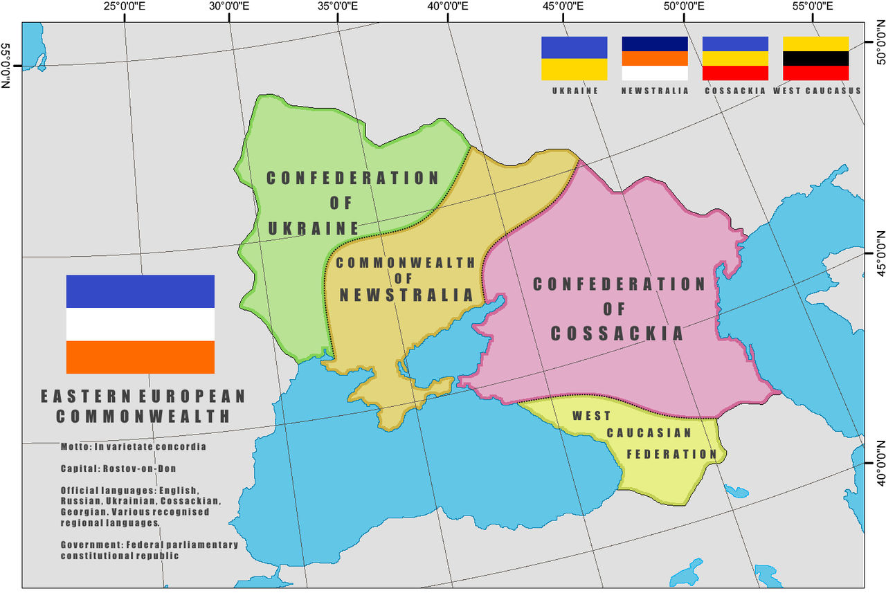
The Eastern European Commonwealth is a nation formed after the collapse of the Nazi Colonial Empire in the East during 1980s. The nation was made possible by the union of the four post-colonial nations: Ukraine, Cossackia, West Caucasia and, most importantly, Newstralia - at least 1/4 of the total population are the descendants of Anglo-Australians, resettled there after the agreement between the German Reich and the Japanese Empire to transfer white "Aryan" population of Australia to the German colonies to a mutual benefit of the increased colonization prospects for both racially-minded empires. While the resettlement was successful, Germany has never succeeded in making the settlers loyal to the Nazi cause - in fact, many Australians willingly joined the existing guerillas, which forced severe German retaliations.

(Basically, something like Man in the High Castle levels of the Nazi Victory with Germany still collapsing as in the most althist scenarios).

the_eastern_european_commonwealth_by_hismajestypurplecat_dfcu6hu-fullview.jpg
And here we we see part of why Hitler wanted all non-Core Reich Germanics to be spread around the East, never having a larger population than the Deutsch. Speaking of which, I see German isn’t listed as a language. Understandable, especially if a decent chunk of the ‘Aryan’ settlers would make it difficult for Germans to feel safe. I expect things got bloody in Ukraine. New Zealand stay independent, or did they also get deported to Europe? Actually, I would adore to see you doing a map on Asia sometime, so we can see what areas are now core Japanese. They only had so many people, and... Oooh, I can only hope the Maori and Aboriginals managed to keep their heads down. I don’t see the Japanese of that time period being great with darker skinned people. Not that that would make the Japanese unique.
View attachment 772095
The Pre-Mongol World according to the Excursio studii ad Horizontes penetrare, 1223
"I was born in the kingdom of Africa during the reign of noble king Osmondo the Good, Caesar of the Orient, King of Sicily, Africa, Egypt, and Syria, protector of the Holy Sepulcher in the year of our Lord 1173 , of the Arabs 569, and of the Hebrews 4934. My father, a trader of grain, travelled much the Mediterranean, and I accompanied him. I left Africa in the year of our Lord 1188 and did not return until the writing of this treatise. I travelled to Turquia, the lands formerly of the Hellenes, where their enlightened lords and princes rule Morea, Athens, and the Isles. I left from Turquia and passed through the Golden Gates on our way to Cumania, We stopped in the great city of Byzance, former Throne of the Goths. Through the gates I went to Tamatarcha, on the edge of the lands of the Cumans. I left there in the summer of 1190 and travelled up the Danube. I first stopped at the town of the Cathars, Nicopolis in the empire of Tocurgaria. There I met a couple of Knights of the German Order, who told me of a coming expedition from Germany and Scandinavia to the lands of the heathens of the North. I passed through the Iron Gates of the Vlachs into the lands of the Uzes. Ruled by the noble and tolerant Cagans of the Ascina clan, their Holy Law permits Arian, Orthodox, Saracen Heathen and Heretic safety in their lands. After this excursion, I returned to Nicopolis and took up the cross for our universal Church with the German Order.
I left for the Baltic sea in 1195, settling with the army of the Crusaders in Culmia. In 1196 I witnessed the baptism of the Prussians at their capital of Tvangste. I fought with their king, Herkus against the rebelling Bartians. In the year of our lord 1201, i fought with the crusaders of Ruzia, Dania, and the Varegians against the Livonians. While in Riga, I met a knight from the isle of Britain, who told me the legends of the great king Arturius and his knights. I chose to follow him home from the Crusade in 1204. I landed in the city of Londinium, a great trade emporium and the greatest city of the Isles of Britain. I returned to my profession as a merchant. For 10 years I traveled the seas of western Europe as a member of the Worshipful Company of Fishmongers. I visited neary every major city in Saxonia, Germany, Spania, and Britain that had an office of the Alnesian League. I had a short dialogue with the Kaiser of Germany in the city of Aquae, he told me of his war against the Henrician heretics of Angria and the great slaughter in his attempts to pacify the province. In the year of our lord 1215 disaster struck me on a voyage to Spartaria, I was ship wrecked off the coast of Tanga and taken into slavery by the Zealots of Marrochium. I spent 3 harsh years there, until by the Grace of God I was saved during when a great coalition of the followers of the Sacristan of Sanctus Jacobus vanquished an army of the Zealot Moors, me and my fellow enslaved Christians were set free. I spent 1 year living in the March of Vandalicia until I took a galley home to Cartaghine. I found that the great empire of the Orient was no more, and that the Kings of Sicily were now solely Kings of Africa. The world I had left 32 years prior had changed in its entirety. Upon returning, I requested an audience with the sublime king Viazaslao II, the powerful though god King of Africa. I told him tales of my adventures around the known world, and received employment with the renowned geographers of Ruspe."
- Agustinu de Cartaghine
What symbol did you use for Norway?
The first proper batch of this project of mine:
View attachment 772133
Notes:
[see above for Afghanistan]
The Sanjak of Scutari was the longest-enduring version of Albania 434 yrs. However, as it was not independent, I have depicted the Republic of Albania on this map. It has been going for thirty years.
The Kingdom of Tlemcen was arguably the longest-enduring version of Algeria, it lasted for 319 years.
The Principality of Andorra - 743 years.
Portuguese Angola existed for 400 years. As it wasn't independent (obviously), the Kingdom of Ndongo (lived to be 70) is shown here [it was not on the basemap for the corresponding years, hence the wobbly borders].
Antigua and Barbuda, has been independent for 40 years (I'm not counting its colonial history).
The Governorate of the Rio de la Plata was the longest lasting version of Argentina (227 years). The longest enduring version is the Argentine Republic (current, and 161 years so far).
Antiquity's Kingdom of Armenia lasted 749 years.
The Commonwealth of Australia is the longest-lasting (some would say only...) version of Australia. Although it was hard to work out when it was de facto independent - either it has been around for 36 years, or 121 years.
Some would argue that the Holy Roman Empire counts as the longest-enduring version of Austria. However, I went with the Archduke of Austria (404 years).
azerbaijan under the Shaddadids lived for 248 years.
The longest living incarnation of the Bahamas was the Colony of the Bahama Islands (255 years). But the longest-enduring independent Bahamas was (and is) the Commonwealth of the Bahamas (49 years...).
Bahrain & its Dependencies (188 years).
The longest-enduring version of Bangladesh or Bengal was the Pala Empire, which lasted 411 years.
As a Colony, Barbados lived for 331 years. The oldest independent Barbados was Barbados as a monarchy (55 years). It recently became a republic, btw.
The longest-enduring version of Belarus has to be the Principality of Polotsk (410 years).
The longest-enduring version of Belgium: Kingdom of Belgium (lasted for 184 successive years).
The longest-enduring version of Belize was when it was the Crown Colony of British Honduras (111 years). Of course, that was not independent, so this map features Belize (41 years so far).
Tricky one Benin - should I go literally with Benin, or would it be more accurate to put down Dahomey? That is the longest-enduring version was the Kingdom of Benin (717 years). But it is worth claiming that modern Benin has nowt to do with the original kingdom. Modern Benin is a successor to the Kingdom of Dahomey (304 years). That is the one shown on this worlda, but I understand some folks won't like that.
Kingdom of Bhutan - it has supposedly endured for 398 years but the NextGen worlda series seems to have a discrepancy in when it became British?? Maybe I just don't fully understand its complicated history.
The longest-enduring incarnation of Bosnia was the Sanjak of Bosnia (lasted 415 years). However, this map shows the Banate of Bosnia (223 years). It was Hungarian, but from my reading it was actually de facto independent.
Final one for this batch - the Bechuanaland Protectorate lasted for 81 years. The modern era's Republic of Botswana has existed for 56 years, and is shown on the map.
Wasn’t Transylvania independent? They had some wars with the Royal Hungarians.
new_british_csa_project_by_theflyingmongooseah_dfcyfyc-fullview.jpg

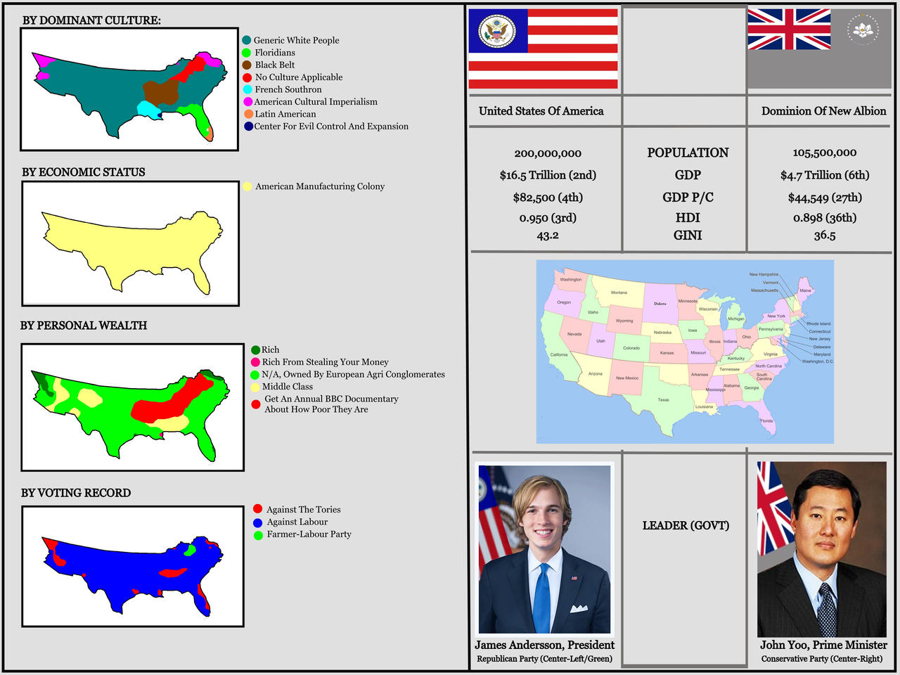
NOTE: James Andersson is a randomly generated name I used for an election game a year or two back. The picture is Representative Jake Auchincloss but modified so it doesn't accidentally break any rules on current politics. I thought Yoo was fine since I'm using him for a different country.
The “Generic White people” part seems almost more ominous than Oklahoma not having a name. This actually makes me wonder about a Dust Bowl in a Confederate Victory. Would the area be filled with whites, with tribes, and if whites, where would the ‘Okies’ go?
Heartwarming to see the Romani got as historically based and comfortably livable a homeland in the USSR as the Jews got. Quite an interesting map. Perhaps someday the Crimean ASSR will be a part of the Tatar SSR. Norway got the Franz Joseph Islands, or did Finland snag that?
I politely beg to disagree. The death of a queen is a moment in History after all, and there is nothing controversial in just acknowledging it.
But this is just me.
It is a moment, and let us leave the image there in memory of her. Best we not comment on it further thought, or it becomes a self fulfilling prophecy on non-map stuff derailing the map thread. I would suggest we celebrate her memory by people making some maps or flags involving her, but it might be in poor taste to do so so quickly.
 
I can only imagine what the coat of arms and flags of all the states would look like after this. For Kansas I am guessing something with John Brown, the chest symbol of the Man of Steel, plus Dorothy’s family house crushing some bourgeoise or capitalist under it. The stockings would stay the same, but the slippers would be sapphire.

And here we we see part of why Hitler wanted all non-Core Reich Germanics to be spread around the East, never having a larger population than the Deutsch. Speaking of which, I see German isn’t listed as a language. Understandable, especially if a decent chunk of the ‘Aryan’ settlers would make it difficult for Germans to feel safe. I expect things got bloody in Ukraine. New Zealand stay independent, or did they also get deported to Europe? Actually, I would adore to see you doing a map on Asia sometime, so we can see what areas are now core Japanese. They only had so many people, and... Oooh, I can only hope the Maori and Aboriginals managed to keep their heads down. I don’t see the Japanese of that time period being great with darker skinned people. Not that that would make the Japanese unique.

What symbol did you use for Norway?

Wasn’t Transylvania independent? They had some wars with the Royal Hungarians.

The “Generic White people” part seems almost more ominous than Oklahoma not having a name. This actually makes me wonder about a Dust Bowl in a Confederate Victory. Would the area be filled with whites, with tribes, and if whites, where would the ‘Okies’ go?

Heartwarming to see the Romani got as historically based and comfortably livable a homeland in the USSR as the Jews got. Quite an interesting map. Perhaps someday the Crimean ASSR will be a part of the Tatar SSR. Norway got the Franz Joseph Islands, or did Finland snag that?

It is a moment, and let us leave the image there in memory of her. Best we not comment on it further thought, or it becomes a self fulfilling prophecy on non-map stuff derailing the map thread. I would suggest we celebrate her memory by people making some maps or flags involving her, but it might be in poor taste to do so so quickly.
Norway did, and the Roma ASSR isn't really settled by Romas much. In fact it's fate was pretty much the same than the Jewish ASSR's


This is a map thread.

That isn’t a map.

Regardless of the Queen being relatively uncontroversial (and even that isn’t properly true. Just ask Kenyans or Ghanaians or young women & children molested by her son who her Royal status continues to shelter but that’s not a discussion for this thread) this kind of tribute doesn’t fit on this thread. Maybe the graphics thread but even then it’s not AH so it’s better placed in Chat.

I often disagree with CalBear’s rulings but this time he’s absolutely right.
 
Last edited:
The Not So American Century, Part Three

Index

-----

Oklahoma, officially the Republic of Oklahoma, is a landlocked country in North America enclaved by the United States of America. The country’s name is derived from the Choctaw words “okla” meaning “people” and “humma” meaning “red” and its residents are informally known as Okies. The capital for administrative purposes is Muskogee and Tahlequah is the largest city. With ancient mountain ranges, prairie, mesas and eastern forests, most of Oklahoma lies in the Great Plains, Cross Timbers and Interior Highlands, all regions prone to severe weather. It is at the confluence of a number of major American cultural regions, which continues to profoundly influence its culture.

Screenshot 2022-09-10 at 11.06.42.png


Screenshot 2022-09-10 at 11.07.03.png


Screenshot 2022-09-10 at 11.07.48.png


The area that is now Oklahoma has been inhabited since the last Ice Age by a wide range of peoples, including Wichita, Tonkawa and Caddo. The eastern part of the country was also home to the Mississippian Culture peoples who flourished between the 9th and 15th centuries, with Spiro being home to a major mound complex. Plains Apache had settled in the region at the time of first contact with the Spanish Empire in 1541. French explorers claimed the area in the early 18th century and at the same time the Comanche entered the region and came to dominate it. The United States claimed the area as part of the Louisiana Purchase in 1803.

In the 1820s and 1830s, the United States forcibly moved tens of thousands of Native Americans from their homelands east of the Mississippi River to the area including present-day Oklahoma. The largest clans to be removed in this way were the Five Civilized Tribes, who dominated the new Indian Territory demographically. All Five Civilized Tribes (which, to a greater or lesser extent, practiced slavery) supported the Confederacy in the First American Civil War and seceded with the Confederate States in 1861.

After secession, increased presence of white settlers in Indian Territory prompted the Five Civilized Tribes to petition the Confederate Government for relief. This resulted in the Confederate States declaring a protectorate over the land in 1890. The Confederate government appointed an Indian Agent and effective internal power was exercised by the tribal governments. As a Confederate protectorate, Oklahoman soldiers saw combat, predominantly as scouts and cavalry, in the Second and Third Civil Wars. After the defeat of the Confederacy, Oklahoma was occupied by Union forces from 1943 and 1949, when it gained its independence.

In the 19th century, Oklahoma was a relatively isolated country but this changed in the 20th century as discoveries of oil pools began to fuel much of the country’s economy. Energy, including oil, natural gas and wind, remains the largest industry in the country and drives much of its economy. Aside from energy, much of the country’s economy is based on agriculture and foreign direct investment is limited by the fact that most of the land is owned according to tribal rules, meaning that they are held in common and leased to individuals for specific purposes, such as home construction or for livestock grazing.

Oklahoma’s varied history means that it has very diverse demographics, being home to 67 recognized Native American tribes, formerly-enslaved African Americans and a number of white and Latin American migrants who came to the country to work in the energy industry. Slavery was outlawed in 1944, during the period of US occupation, although former slaves were denied citizenship in the tribes of their former owners and have faced several discriminatory barriers for many decades since.

Oklahoma is governed by a complex interplay of Native American traditions, being divided between Tribal, Urban and National governments. Tribal governments control most rural areas and legally own all the land in the country, leasing it to individuals and businesses. Urban governments are found in towns and cities of sufficient size, where residents are allowed to elect councils and mayors to decide internal regulations and laws. The national government is made up of representatives of the various tribal governments and mostly coordinates matters relating to foreign and monetary policy. The extent of tribal governments has led to a patchwork of legal jurisdictions which can be confusing to outsiders.
 
Last edited:
Part three in a short series on a slightly different North America (here and here for the other two)...

-----

Oklahoma, officially the Republic of Oklahoma, is a landlocked country in North America enclaved by the United States of America. The country’s name is derived from the Choctaw words “okla” meaning “people” and “humma” meaning “red” and its residents are informally known as Okies. The capital for administrative purposes is Muskogee and Tahlequah is the largest city. With ancient mountain ranges, prairie, mesas and eastern forests, most of Oklahoma lies in the Great Plains, Cross Timbers and Interior Highlands, all regions prone to severe weather. It is at the confluence of a number of major American cultural regions, which continues to profoundly influence its culture.

View attachment 773028

View attachment 773029

View attachment 773030

The area that is now Oklahoma has been inhabited since the last Ice Age by a wide range of peoples, including Wichita, Tonkawa and Caddo. The eastern part of the country was also home to the Mississippian Culture peoples who flourished between the 9th and 15th centuries, with Spiro being home to a major mound complex. Plains Apache had settled in the region at the time of first contact with the Spanish Empire in 1541. French explorers claimed the area in the early 18th century and at the same time the Comanche entered the region and came to dominate it. The United States claimed the area as part of the Louisiana Purchase in 1803.

In the 1820s and 1830s, the United States forcibly moved tens of thousands of Native Americans from their homelands east of the Mississippi River to the area including present-day Oklahoma. The largest clans to be removed in this way were the Five Civilized Tribes, who dominated the new Indian Territory demographically. All Five Civilized Tribes (which, to a greater or lesser extent, practiced slavery) supported the Confederacy in the First American Civil War and seceded with the Confederate States in 1861.

After secession, increased presence of white settlers in Indian Territory prompted the Five Civilized Tribes to petition the Confederate Government for relief. This resulted in the Confederate States declaring a protectorate over the land in 1890. The Confederate government appointed an Indian Agent and effective internal power was exercised by the tribal governments. As a Confederate protectorate, Oklahoman soldiers saw combat, predominantly as scouts and cavalry, in the Second and Third Civil Wars. After the defeat of the Confederacy, Oklahoma was occupied by Union forces from 1943 and 1949, when it gained its independence.

In the 19th century, Oklahoma was a relatively isolated country but this changed in the 20th century as discoveries of oil pools began to fuel much of the country’s economy. Energy, including oil, natural gas and wind, remains the largest industry in the country and drives much of its economy. Aside from energy, much of the country’s economy is based on agriculture and foreign direct investment is limited by the fact that most of the land is owned according to tribal rules, meaning that they are held in common and leased to individuals for specific purposes, such as home construction or for livestock grazing.

Oklahoma’s varied history means that it has very diverse demographics, being home to 67 recognized Native American tribes, formerly-enslaved African Americans and a number of white and Latin American migrants who came to the country to work in the energy industry. Slavery was outlawed in 1944, during the period of US occupation, although former slaves were denied citizenship in the tribes of their former owners and have faced several discriminatory barriers for many decades since.

Oklahoma is governed by a complex interplay of Native American traditions, being divided between Tribal, Urban and National governments. Tribal governments control most rural areas and legally own all the land in the country, leasing it to individuals and businesses. Urban governments are found in towns and cities of sufficient size, where residents are allowed to elect councils and mayors to decide internal regulations and laws. The national government is made up of representatives of the various tribal governments and mostly coordinates matters relating to foreign and monetary policy. The extent of tribal governments has led to a patchwork of legal jurisdictions which can be confusing to outsiders.
Small nitpick, "Evangelical" is misspelt ("Evalgelical") in then wikibox
 
Part three in a short series on a slightly different North America (here and here for the other two)...

-----

Oklahoma, officially the Republic of Oklahoma, is a landlocked country in North America enclaved by the United States of America. The country’s name is derived from the Choctaw words “okla” meaning “people” and “humma” meaning “red” and its residents are informally known as Okies. The capital for administrative purposes is Muskogee and Tahlequah is the largest city. With ancient mountain ranges, prairie, mesas and eastern forests, most of Oklahoma lies in the Great Plains, Cross Timbers and Interior Highlands, all regions prone to severe weather. It is at the confluence of a number of major American cultural regions, which continues to profoundly influence its culture.

View attachment 773028

View attachment 773029

View attachment 773030

The area that is now Oklahoma has been inhabited since the last Ice Age by a wide range of peoples, including Wichita, Tonkawa and Caddo. The eastern part of the country was also home to the Mississippian Culture peoples who flourished between the 9th and 15th centuries, with Spiro being home to a major mound complex. Plains Apache had settled in the region at the time of first contact with the Spanish Empire in 1541. French explorers claimed the area in the early 18th century and at the same time the Comanche entered the region and came to dominate it. The United States claimed the area as part of the Louisiana Purchase in 1803.

In the 1820s and 1830s, the United States forcibly moved tens of thousands of Native Americans from their homelands east of the Mississippi River to the area including present-day Oklahoma. The largest clans to be removed in this way were the Five Civilized Tribes, who dominated the new Indian Territory demographically. All Five Civilized Tribes (which, to a greater or lesser extent, practiced slavery) supported the Confederacy in the First American Civil War and seceded with the Confederate States in 1861.

After secession, increased presence of white settlers in Indian Territory prompted the Five Civilized Tribes to petition the Confederate Government for relief. This resulted in the Confederate States declaring a protectorate over the land in 1890. The Confederate government appointed an Indian Agent and effective internal power was exercised by the tribal governments. As a Confederate protectorate, Oklahoman soldiers saw combat, predominantly as scouts and cavalry, in the Second and Third Civil Wars. After the defeat of the Confederacy, Oklahoma was occupied by Union forces from 1943 and 1949, when it gained its independence.

In the 19th century, Oklahoma was a relatively isolated country but this changed in the 20th century as discoveries of oil pools began to fuel much of the country’s economy. Energy, including oil, natural gas and wind, remains the largest industry in the country and drives much of its economy. Aside from energy, much of the country’s economy is based on agriculture and foreign direct investment is limited by the fact that most of the land is owned according to tribal rules, meaning that they are held in common and leased to individuals for specific purposes, such as home construction or for livestock grazing.

Oklahoma’s varied history means that it has very diverse demographics, being home to 67 recognized Native American tribes, formerly-enslaved African Americans and a number of white and Latin American migrants who came to the country to work in the energy industry. Slavery was outlawed in 1944, during the period of US occupation, although former slaves were denied citizenship in the tribes of their former owners and have faced several discriminatory barriers for many decades since.

Oklahoma is governed by a complex interplay of Native American traditions, being divided between Tribal, Urban and National governments. Tribal governments control most rural areas and legally own all the land in the country, leasing it to individuals and businesses. Urban governments are found in towns and cities of sufficient size, where residents are allowed to elect councils and mayors to decide internal regulations and laws. The national government is made up of representatives of the various tribal governments and mostly coordinates matters relating to foreign and monetary policy. The extent of tribal governments has led to a patchwork of legal jurisdictions which can be confusing to outsiders.
I was wondering if it wasn’t strange for them to add ‘American’ to all ethnicities and not have some other names used for them, but looking at our other maps I see it is quite a diverse group of terms. For instance, Black American in Oklahoma, African American in New Afrika, and African in the US. Despite all the names for the groups, would you say the three countries all have generally the same idea in what groups are classified as what? With perhaps some leniency in the US between different types of white, as I feel New Afrika and Oklahoma only consider exceptions to be Hispanics, due to the chance of them having Native or African blood in them. Plus the the other stuff. Looking back on your previous maps, I see Brooklyn is its own city still. Did it annex Manhattan and other areas as time went on, or keep to its own borough without direct expansion?
 
Whether or not you think the queen of the UK deserves to be honoured is moot; there's a designated place for that.

This is not that place.
Noted
It is the map thread.

I can see a map made in the Queen's memory being relevant (say for example an ATL with more/different commonwealth realms).
But there are other threads in the forum to talk about her passing, give your thoughts and feelings etc.
Noted and acknowledged
This is a map thread.

That isn’t a map.

Regardless of the Queen being relatively
uncontroversial (and even that isn’t properly true. Just ask Kenyans or Ghanaians or young women & children molested by her son who her Royal status continues to shelter but that’s not a discussion for this thread) this kind of tribute doesn’t fit on this thread. Maybe the graphics thread but even then it’s not AH so it’s better placed in Chat.

I often disagree with CalBear’s rulings but this time he’s absolutely right.
That sounds a bit too harsh to me (though I see that's probably the very controversy that CalBear was trying to avoid) but noted
That is both a current event, and in this specific case, very much NOT a map.
Noted and understood.
But still, with all due respect:
yeah agreed, probably not the best time to be a rules monger Calbear
 
Last edited:
Status
Not open for further replies.
Top