This is an old revision of the document!
High Kingdom of Manticore
The basic premise of this setting is that the Rockall Bank was pushed up above sea level between 25 and 35 million years ago, forming a large and rather mountainous island to the northwest of the British Isles. This idea was originally mine (not that other people thought of it before me), but the setting has since been influenced by a wide variety of ATLs, including the Tarrantry stories and the Tol Galen AU on Shipbucket.
Geography
The history of Calendor begins roughly four to five thousand years ago with the arrival of the Sindar from the European mainland. These are essentially Tolkien's Sindar elves transported into the world of Manticore. My version of the elven migration begins in the northern reaches of the Ural Mountains among the predecessors of what are now the Finno-Ugric peoples of Finland and Hungary. The Sindar migrated through what are now Russia, Germany, and the Low Countries before taking to the sea and travelling first to Britain and then Ireland before crossing open Atlantic to the island they named Calendor. The vulgar language of the Sindar, Sindarin, is seen as a descendant of primarily Brythonic Celtic, with a few elements descended from the Finno-Ugric ancient elvish language, which is still used in formal and religious circumstances.
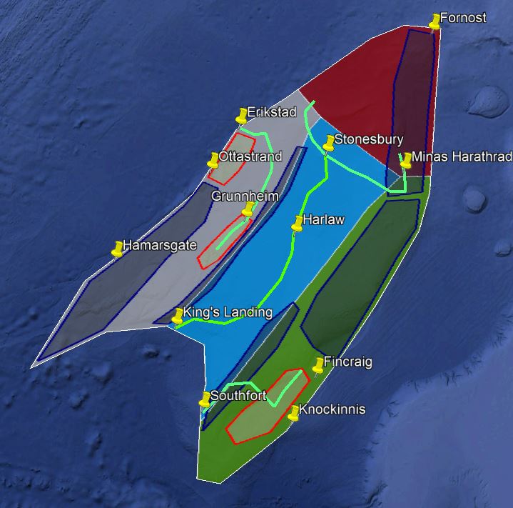
For almost two thousand years, the Sindar tribes ruled Calendor by themselves. Although their written language was limited to runes and their agriculture remained relatively undeveloped, the relatively peaceful coexistence of the Sindar tribes meant that they were able to expend huge amounts of wealth and resources on massive building projects that still dominate some of Calendor's most prominent geographic landmarks. The fairly sudden climatic cooling in the centuries before the Medieval Warm Period weakened the warm-weather agricultural package the Sindar used in the southern regions of Calendor and allowed the incremental colonization of the southeast coast by Goidelic Celts from Ireland beginning in the 4th and 5th centuries. Further outside colonization of Calendor occurred in the 8th and 9th centuries by Anglo-Saxon raiders landing on the southeast coast (the concave part) and Norse Vikings landing on the northwest coast in the 10th and 11th centuries. Over these centuries, the Sindar were pushed further and further north until the island reached a new equilibrium point as shown in the map above.
The Vale of Manticore is the blue region in the center of the island. Historically, settlement was divided at Harlaw between Anglo-Saxons to the north and Anglo-Normans to the south. Extensive English immigration in the 16th and 17th centuries has led to significant cultural assimilation among the existing Vale populations. In modern times, the Middle English and Middle French languages are still found in some small villages and in personal use among the nobility, but modern English is spoken universally elsewhere. The River Anduin runs from King's Landing on the Bight of Manticore through Harlaw to Stonesbury, where the river splits into the River Langwell, which runs up into Glastrymore and then past Minas Harathrad into the Eryd Caran, and the River Greylin, which runs up into the Grayrike.
Glastrymore is the green region on the eastern coast of Calendor. It is inhabited primarily by Goidelic Celts, although there are isolated pockets of Brythonic Celts in the extreme south of the region. Knockinnis and Fincraig are by far the largest cities in the region, while the agricultural heartland of the region is found in the Kenglenn, inland of the two cities. The River Dun runs from the northern reaches of the Kenglenn, across the Eastmarch, and reaches the ocean at the Southfort. Northern Glastrymore is covered by a range of hills known as the Green Hills, visually reminiscent of the mountains of Connacht in Ireland.
The Grayrike is the gray region on the western coast of Calendor. It is inhabited by the Manticoran Norse, a group of Nordic Fennoscandians descended from Viking raiders. It is dominated by two parallel mountain ranges, the Westmarch on the border with the Vale and the Gray Mountains in the south, a range similar to Norway's mountains and fjords but significantly larger. Between the Gray Mountains and the Westmarch is the Grunndale, a large agricultural valley that also serves as the source of the Kingsforce, the large river that flows down from the Grunndale to the Eriksfjord. North of the Gray Mountains is the Langstrand, a large coastal plain bracketed by the city of Ottastrand to the south and the large Eriksfjord to the north, with the Norse seat of government at Erikstad on the Eriksfjord.
Carandor, the Red Realm in northern Calendor, is the modern name for the realm of the Red King in Fornost. During the period of Sindarin domination of Calendor, Fornost and the nobles of the Eryd Caran, the northern mountain range that is a significantly larger extension of the Green Hills of northern Glastrymore, were subordinates of the Sindar high king at Tol Galen. The collapse of the Sindar kingdom, combined with Gaelic and Saxon invasions, has left the Manticoran Sindar concentrated in the north of the island. Although the Sindar claim that the name of the Red Mountains comes from the orange glacial deposits that are common across the valleys of the range, the northern Gaels say that they coined the name, after the blood spilled by the Sindar in dozens of attempts by the Norse, Saxons, and Gaels to attack the Sindar.

