You are using an out of date browser. It may not display this or other websites correctly.
You should upgrade or use an alternative browser.
You should upgrade or use an alternative browser.
Christory's Optimal Borders Surveys (curent maps: China, Russia, Turkey/Ottomans)
- Thread starter Christory
- Start date
Here's mine, i hope i'm not TOO late for china


edit: I did some slight alterations to Russia ounce i noticed that Alaska wasn't painted
edit: I did some slight alterations to Russia ounce i noticed that Alaska wasn't painted
Last edited:

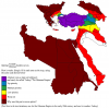
Mostly with the following logic:
Purple = Turkish majority/plurality (and the Straits)
Blue = Misak-ı-Milli borders (not exactly, I know)
Green = non-Arab muslim majority/plurality, plus close to Anatolia Aegean Isles and some extra land in Thrace
Yellow = In Europe mostly to connect green, in Caucasia everything but core Armenia and core Georgia. In Arab lands Holy Cities, Iraqi oil and Suez Canal
Red = not much to gain or core area of of a Christian state (other than Bulgaria). Egypt and Libya could be considered but too much hassle. in Lebanon Christians might be casus belli for Europeans
Dark Red = Wallachia sacrifices the Danube border, Sudan is too much (though Red Sea coast could be made lighter red), Tunisia too far with two European great powers interested in it.
I left aside the fact that i'm not the ottoman's biggest fan and based this on Rum and Turkic buddies and their ambitions for the world

Share: