The R-QBAM main thread

I said all I wanted to say regarding historical patches on Friday, but there are a few more things I feel like replying to. Earliest first;

Hey, @Tanystropheus42, would you like me to make a Google Docs document as a Q-BAM repository?

By all means go ahead, just leave a link somewhere prominent once you've done it. I've been meaning to threadmark/clean up the various patches for a while, so I'm quite likely to thread-mark it at some point as well.

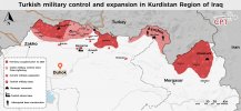
In Mali, why is there a distinction between the Jamaat Nasr al-Islam wal Muslimin? shouldn't it be colored as a single entity that has swore allegiance to AQ? like this example below?

Honestly, Mali still annoys me as it's still inaccurate. What you see was just the best I could cobble together from dozens of disparate, often contradictory sources. As a result there are plenty of little flaws all over the place, and while I want to take another stab at it, it was so annoying to do last time that I've been putting it off indefinitely. Until I get around to modding Mali again, consider all factions to be provisional.

Personally, I would like to see a completed world map base before ANY nations are put in, modern OR historical, BUT, it's not my project and @Tanystropheus42 is doing the work of the Gods with his beautiful map. Must admit though, the first thing I look for is @Rac98 's marvellous rivers.

I want the base done too, but sometimes a change of scenery to avoid burnout is a good thing, hence why I'll be doing historical patches through December.

There's actually one other historical patch I have planned - once I've done India I'll be producing a patch for the British Raj in 1914 showing as much detail as I can. I've been trying to fix the broken QBAM Raj map for nearly six years after all. It's been on my to-do list for quite a while, and I really want to finish it now I have a shiny new basemap to work from.

*slaps Africa* "This bad boy can fit a shit ton of civil wars!"
I was expecting many rebel groups to appear on future patches, given Africa's stability status, but dear God the amount of them in D.R. Congo...

As promised, a colour key for the factions I judged were notable enough to show, arranged roughly from north to south. After a fair amount of culling we're down to just 32 groups, but I'm still not completely happy with it, and I suspect one or two more groups need to be removed, but after way too much work on it already I just want to put a pin in it and move on.

1668304321865.png

And to be honest, there aren't that many African civil wars left - just Somalia (but of course) and northern Mozambique. There's a reason I'm predicting Africa will be done by the end of the month - most of the difficult stuff is already done.

Very nice, but why is Lake Victoria divided that way? It leaves one with the impression that there are sections of the lake that are international waters which isn't the case.

Those island boxes aren't showing marine borders, just who controls what islands, though come to think of it a version of the R-QBAM with maritime borders could be a useful addition. I'll add it to the to-do list.

EDIT 1; Ninja'd - what @MapleRepublic said.

Well, an "quick" update here... I can finally say that the Niger Basin is complete!!! And wow Nigeria was a challenging place, so yeah, the plan still the same as before, doing Chad and Cameroon then going into the Nile, as usual.

Nice to see more progress as always.

EDIT 2; Quick progress update - Zimbabwe is already done, Malawi and Mozambique are coming along well. Expect the next patch in about two days.
 
Last edited:
1668379770873.png
1668379852158.png


Okay, so another update:
- Camaroon's coastline basins, Equatorial Guinea basins and all of the Chad basin are complete (+ Wadi Howar and Magrur on Sudan);
- It's curious how wet and dry Chad is, in the south the Chari and Logone create a huge wetland area that is dubius where it starts and ends, you cound say it goes all the way to the Sudan border but is dry... It's confusing; on the north otherwise the remmenants of the Mega-Chad paleolake as dozens of wadis coming from the Sudanese and Tibesti highlands, Lac Fitri with the Batha wadi and the Bodélé Depression paint a lot of stuff here;
- 3 minor adjustments on the the coastline layer (@Tanystropheus42 , pinging just to not miss), Kashimbila Dam on the Katsina river on Nigeria-Cameroon border and the Ounianga Lake's (Lac Yoa, Katam and Ounianga-Seen? I hope that's the correct name in last one) from north Chad where missing, so yeah they are here now;
- And the Niger (the country) fully done now too;
Next step: Upper Nile Basin

How long will it take for you to complete Central Africa? If yes, are there any geographical details there that could slower down the process?
Well, the Congo Basin will an patience challenge indeed, the reason I slowed so much from my usual is that since I started looking towards adding wetlands and dry waterbeds even with an source image in to draw on you can absolutely mess it up if not made with attention, so I started zooming insed the QGIS program data to get their shape and position right, and well since I'm already there doing the same with rivers it's not a far fetch, it gets the rivers more detailed and right positioned, actully I'm cosidering doing the smae thing with Europe later to get everything with the same standarts; the caviat of course is that this checking is only really productive on the weekends, + also Central Asia got me stuck from long time so I'm catching up in great chunks to the current patch I would say;
Now what would slow down on the Congo Basin specifically beyond the share amount of rivers is there is an giant florested wetland area beyond Lac Tumba that is quite an fuzzy border to map out (just like the Niger delta and the Chari-Logone central wetland) the sourcer on that are a little conflitant, beyond this idk, by the size alone it will take more than one week for sure to be done.
 
Last edited:
Not much to say here today - three more countries done, just ten more to go and I've finished Africa.

I would've had this done hours ago if I hadn't spotted the Mozambique coastline near the Tanzanian border was wrong while adding the insurgency there. After some major re-tooling, I'm not entirrly happy with it, but its better than it was.

Oh, @Rac98 , thanks for pointing out the missing lakes. The Kashimbila reservoir was missing as it was only filled in 2018, and google maps apparently hasn't updated their basemaps since then, which is annoying but what can you do. I'd also overlooked those lakes in northern Chad, but in this case I'd say they're almost all too small to register at this scale. The biggest one gets a single pixel, and I still think that's being generous. Basemap has been duly patched. Anyway ...


Patch 71 - South West Africa;
- Added Malawi
- Added Mozambique (showing insurgency in the north west)
- Added Zimbabwe

1668494883736.png
 
It's not big and not many people know about it compared to Syria but you might want to patch the Turkish military presence in Northern Iraq too
 

Attachments

  • 2.jpg
    2.jpg
    397.6 KB · Views: 247
  • 1.jpeg
    1.jpeg
    379.9 KB · Views: 230
I have a confession. There are a few areas of the world where I've done a lot of work but haven't showcased anything yet as they're still stuck as a WIP. Among a few others, I've had an advanced South Africa WIP lying around for over a year now that I've never quite gotten around to posting.

The plan yesterday was to work on Somalia, but having slept terribly the night before I didn't feel up to messing around with a messy civil war. So instead I took a crack at updating the South Africa WIP. All I needed to do was double check my previous work, add a few lakes and the Namibian coastline and everything was golden. I've also included the Somali coastline in this patch as well, so I can say that I've finished the African mainland.

Oh, and apparently I accidentally coloured all the coasts in the South East Africa patch in the international border colour. That should be fixed here.

I still have the factions of Somalia to do of course, in addition to the four island nations in the Indian Ocean I'd lump in with Africa, but geographically its done. All in all I expect those two jobs to take a week tops. After that I'm tempted to do another North America patch adding Newfoundland, then I'll be getting cracking on the historical patches.


Patch 72 - Southern Africa;
- Added Namibia
- Added Botswana
- Added South Africa
- Added Lesotho
- Added Eswatini
- Added Tristan da Cunha (completing St Helena, Ascension and Tristan da Cunha)
- Added Bouvet Island (finishing Norway, excluding Antarctic claims)
- Added the Somali coastline (factions to come over the weekend)

1668634270891.png
 
I have a confession. There are a few areas of the world where I've done a lot of work but haven't showcased anything yet as they're still stuck as a WIP. Among a few others, I've had an advanced South Africa WIP lying around for over a year now that I've never quite gotten around to posting.

The plan yesterday was to work on Somalia, but having slept terribly the night before I didn't feel up to messing around with a messy civil war. So instead I took a crack at updating the South Africa WIP. All I needed to do was double check my previous work, add a few lakes and the Namibian coastline and everything was golden. I've also included the Somali coastline in this patch as well, so I can say that I've finished the African mainland.

Oh, and apparently I accidentally coloured all the coasts in the South East Africa patch in the international border colour. That should be fixed here.

I still have the factions of Somalia to do of course, in addition to the four island nations in the Indian Ocean I'd lump in with Africa, but geographically its done. All in all I expect those two jobs to take a week tops. After that I'm tempted to do another North America patch adding Newfoundland, then I'll be getting cracking on the historical patches.


Patch 72 - Southern Africa;
- Added Namibia
- Added Botswana
- Added South Africa
- Added Lesotho
- Added Eswatini
- Added Tristan da Cunha (completing St Helena, Ascension and Tristan da Cunha)
- Added Bouvet Island (finishing Norway, excluding Antarctic claims)
- Added the Somali coastline (factions to come over the weekend)

View attachment 789794
What if Somalia became Virgin Earth?
 
You know how sometimes a job you think'll take ages ends up taking no time at all? I just had that with Somalia. I was expecting this to be a four-day job, in the end (thanks largely due to tracing over a decent basemap), I got it done in a little over a day.

That map I linked to just now really is good. It's from a site that produces really good maps and detailed analyses of current conflicts but locks most of them behind a paywall. However they do put out the odd free sample, and I was lucky enough that one of those free-to-access maps shows the situation in Somalia on the 14th December 2021, only a fortnight off.

That article and map explains the situation rather well, but to summarise; Somalia has been suffering from a particularly chaotic civil war for over three decades now, with no end in sight, the main factions being the fractious internationally-recognised government and associated forces, the Al-Qaeda-affiliated militant group Al-Shabaab which operates a parallel government across much of the countryside and the Somaliland separatists off to the side.

The central government divides Somalia into six regional states plus Mogadishu, which has its own special status. As mentioned previously the breakaway state of Somaliland in the north claims independence, (though bits of eastern Somaliland are currently controlled by pro-government autonomist forces), and as such refuses to answer Mogadishu's calls, meaning that in effect somalia is a federation of five states (excluding Somaliland) and one oddly governed capital city. These states do have a fair degree of leeway - several have in the past been either de-facto independent or governed by government-aligned warlords.

Of particular note is Puntland in the north, bordering Somaliland. As with Somaliland, the region has been relatively stable in stark contrast to the rest of Somalia, however Puntland does not claim independence, merely professing to be an autonomous region of wider Somalia. During those periods of the civil war when government authority collapsed, Puntland was de-facto independent. Of course, since the reconstitution of a shaky central government Puntland has deferred to Mogadishu, however it retains its highly autonomous character.

And then there's the fact that the government isn't even in firm control of that much territory. Aside from the large swathes of countryside de-facto administered by Al-Shabaab, firm government control is largely limited to the cities and a few key roads linking them.

Hence my choice of colours. Areas of firm government control are shown in blue, areas of looser control in a lighter shade of blue. Puntland gets its own pair of similar shades of blue to show both that it is distinct while part of Somalia and to deliminate areas of firm and loose control ( a less extreme problem than in the rest bof Somalia). Somaliland is in light brown, Al-Shabaab in dark burgundy (to match with the previously-used Al-Qaeda colour) and finally pockets of IS control in the northern mountains in almost-black (again, matching previously-used colours). Lastly there's a vaguely pro-government militia in Galmudug State that in the last quarter of last year went on quite the conquering spree in opposition to government forces. As detailed here (I've used that link a lot, haven't I?), by the end of the year they were past their zenith but still controlled a couple of towns, and are coloured using the darkest shade of blue.


With the last big job done, all I have left to do of Africa are the East African island nations (Madagascar, Mauritius, the Comoros and the Seychelles). which should only take two to three days.

Africa will be finished at some point over the weekend.


Patch 72 - Southern Africa;
- Added Somalia, showing civil war (see above for breakdown)
- Mildly tweaked Somaliland
- Patched in Turkish occupation of northern Iraq (thanks @felixs )

1668734113366.png
 
It's ... done?

I don't quite believe it myself but after several months of grinding I've finally finished Africa.

I'm not actually sure where to go next. On the one hand I do want to get historical patches done, and it is what I said I'd do. On the other, I feel like I'm currently on a roll and don't want to break the streak; if I start now I reckon I'll have South Asia done before new years.

So yeah, I'm a little conflicted. I'll make my mind up tomorrow and we'll see where things go from there.

Some quick notes. I was surprised by just how off the Seychelles are in the QBAM. Something I've noticed over the last year is that the coasts and international borders on the classic QBAM are usually pretty close to being right. Don't get me wrong, the whole QBAM is in an unknown projection and that skews things, but whatever that projection is is close enough to Robinson that on the small to medium scale things still line up rather well. Not so with the Seychelles. Every island is wrong - either located wrong relative to its fellows or much bigger than it should be. A good example is the main island of Mahe; in the QBAM it has an area of 14 pixels, when in actual fact it should be closer to 4.

It was bad enough that I actually went to the trouble of creating a quick and dirty GIF to illustrate just how off the QBAM is (the R-QBAM colours the Seychelles fluorescent green);
1668941156090.gif


This patch is also the first we've seen of France since Corsica back in March, adding in most of the French Indian ocean territories (Mayotte, Reunion, and 2/5ths of the French Southern and Antarctic Lands (the Crozet Islands and the Scattered Islands)).

One final thing, by my count I just hit 150 countries finished (including de-facto nations). Just a shame a lot of the ones I have left are either big (China, India, Australia), have annoying coastlines (Chile, Indonesia, Bangladesh) or both (Canada, the last three quarters of Russia).


Patch 80 - East African Islands;
- Added the Comoros
- Added the Seychelles
- Added Mauritius (showing the autonomous island of Rodrigues)
- Added Madagascar
- Added Reunion
- Added Mayotte
- Added bits of the French Southern and Antarctic Lands

1668941342113.png
 
It's ... done?

I don't quite believe it myself but after several months of grinding I've finally finished Africa.

I'm not actually sure where to go next. On the one hand I do want to get historical patches done, and it is what I said I'd do. On the other, I feel like I'm currently on a roll and don't want to break the streak; if I start now I reckon I'll have South Asia done before new years.

So yeah, I'm a little conflicted. I'll make my mind up tomorrow and we'll see where things go from there.

Some quick notes. I was surprised by just how off the Seychelles are in the QBAM. Something I've noticed over the last year is that the coasts and international borders on the classic QBAM are usually pretty close to being right. Don't get me wrong, the whole QBAM is in an unknown projection and that skews things, but whatever that projection is is close enough to Robinson that on the small to medium scale things still line up rather well. Not so with the Seychelles. Every island is wrong - either located wrong relative to its fellows or much bigger than it should be. A good example is the main island of Mahe; in the QBAM it has an area of 14 pixels, when in actual fact it should be closer to 4.

It was bad enough that I actually went to the trouble of creating a quick and dirty GIF to illustrate just how off the QBAM is (the R-QBAM colours the Seychelles fluorescent green);
View attachment 790561

This patch is also the first we've seen of France since Corsica back in March, adding in most of the French Indian ocean territories (Mayotte, Reunion, and 2/5ths of the French Southern and Antarctic Lands (the Crozet Islands and the Scattered Islands)).

One final thing, by my count I just hit 150 countries finished (including de-facto nations). Just a shame a lot of the ones I have left are either big (China, India, Australia), have annoying coastlines (Chile, Indonesia, Bangladesh) or both (Canada, the last three quarters of Russia).


Patch 80 - East African Islands;
- Added the Comoros
- Added the Seychelles
- Added Mauritius (showing the autonomous island of Rodrigues)
- Added Madagascar
- Added Reunion
- Added Mayotte
- Added bits of the French Southern and Antarctic Lands

View attachment 790563
Congrats on 150 man, from my selfish perspective I'd like to see the whole map finished so I can start translating all of my QBAMs onto it, but I'd recommend doing whichever is more interesting. Going to need a fair few patches for a future borderpool, so the more historical maps the better too.
 
1668990626238.png
1668990677679.png
1668990706172.png


Welp, better at a snail pace than never: The Nile Basin is done! I hope?

First of, congratulations @Tanystropheus42 for finishing Africa! Quite a journey indeed, and well I have some thoughts and notes you might like;

But, summing up the changes:
- The entire Nile Basin, from Lake Victoria to the Darfur and Ethiopian highlands has it's rivers and wadis map out, it was more complex than I thought but it's done;
- However I'm not sure if I did catch the Sudd and Gambella wetlands right, latter I'll do an revision here;
- The Lake Turkana basin as well the Eritreian ones, the inner Ethiopian ones, Djbouti and that Somaliland and Puntland ones are done too;
- There are 2 dams and 2 lakes missing that I added, the Upper Atbara Dam in Rumaylah (Sudan) and the Karkabet Dam on the western part of Eritreia, and Lake Bakili and Lake Karum on the Ethiopian-Eritrean border and although these two are small, they together form part of a larger dry lake and that's why I added them;
- Also on Chad I still did leave Lac Yoa there because there's a settlement in that place, the other bigger lake futher east is not inhabited and since both are well, in the middle of nowhere, I still think it's valid to show it;
- I did an rework on the Egyptians canals, stuff is a lot tighter now, far from perfect, but readable on the main stuff;
And that's was it for today, next I'll finish Somalia, Keny and Ethiopia, then I'll go the the Congo...

Now one thing I didn't comment ealier, for lack of time, when you did southen Africa patch is that I swear that South Africa was in the same situation as Spain before and not a unitary state, that info caught me off guard, so I dig in to check... Just a little. So, yes South Africa is a unitary state, however it's an special type of unitary? Aparently there is a ton of unitary states that have a model of devolution called regional states, and although the name sounds a little too obvious it's different from the states in federalist nations.
So in essence an regional state has more powers than what a normal adminitrative subdivision would have in a unitary nation, but still fully at mercy of the capital gov. different from the federations. So it's kinda an midway between unitary and federations, South Africa, France, Tanzania, China, Indonesia, Ukraine, as well Spain (despite that de facto it works as a federation) and the UK countries fall into that category, and thus dozens other nations from Europe and Africa too.
So idk, should that be something to be worked on the de facto political map or leavead for when the normal subdivisions eventually get to be worked on?
And btw this wikipedia list here I believe gets everyone that's is either ferderalist, unitary or this "regional" models.

Lastly going by that list, Iraq, Sudan, South Sudan and Comoros are federations... So I guess these will need a little patch?

And I guess that's everything, my schedule latley sure is getting stuff slow but I still going, well, see you guys later!
 
Last edited:
After a couple of days' work I've expanded the existing 1914 map out to cover the rest of the 1914 blank map.

I thought that would be an easy job, but I was wrong; North Africa, while relatively straightforward, took rather longer than I expected it to (this mapwas particularly helpful for Morocco), and I fell down a rabbit hole trying to figure out the Ottoman-Persian border. That became a surprisingly intensive job, for all that it only changes a dozen or so pixels.

To cut a really long story short, Iran's western border isn't as old as it's sometimes claimed to be. A small bit of geography trivia that I've occasionally seen doing the rounds on the internet is that Iran's western border (with Iraq to the south and Turkey to the north) is the oldest border in Asia. This ... isn't really true. While the modern border is broadly based on the terms of the 1639 Treaty of Zuhab, well, that treaty didn't properly define a border. Both sides agreed that they would have a mutual border that generally followed the path of the modern one, but no definitions were made or markers laid down. It helped that the area was (and still is) largely mountainous and desolate - they didn't need a properly defined border at the time, geography did most of the work for them.

My attention was first drawn to the ephemeral nature of the Ottoman-Persian border by this map, showing Persian/Iranian territorial changes from 1790 to the present day (that site BTW is really rather good, full of all kinds of useful maps of the Middle East and surrounding regions). The map in question is detailed and laptop-freezingly big (you have been warned), but while it shows that, yes, the 1639 border fluctuated a fair amount, it also shows that most of the border had been actually delimited just prior to the First World War from 1911 to 1914. However there's a catch - it also shows that there was a land exchange between Iran and Turkey in 1934. Hence almost all of the border should just be a trace over of the modern borders, but with a few small modifications to account for the 1934 territorial exchange. The real problem is that that map doesn't show what territory actually changed hands that clearly at all.

Looking for further sources, I stumbled on this, a US government study from 1964 summarising the geography and history of the by then Irainian-Turkish border, which turned out to be pretty useful. It corroborated a fair amount of the previous map, but while the last map was sloppy, this one provided no maps at all. I couldn't for the life of me find a dedicated map showing what chunks of land were actually exchanged, so in the end I got creative. A couple hours trawling wikipedia threw up these two maps from 1916 and 1918 respectively that relatively clearly showed the pre-exchange border. Then it was just a case of porting them into Paint.net, warping them to fit the R-QBAM and drawing on the modified borders as necessary.

That whole process however took an annoyingly long time to finish, especially because a tonne of sources were unclear or otherwise contradictory, and I wanted to be absolutely clear before I drew anything on. There's a tonne more stuff I haven't mentioned here as this explanation is already long enough as it is.

So yeah, it was much more of a grind than I was expecting, but it's now done, finally.

Europe, 1914, expanded;
1669366217690.png

The map also shows the Russian sphere of influence in Persia (the British sphere is off-map to the south-east) and de-facto French control of Morocco against the Berber Zaian Confederation in the interior (here shown in in orange). I also tweaked the basemap coasts around Morocco along with a few other minor changes; they will be included in the next patch to the main map.


Next up on the schedule is a map of Europe in 1929 just prior to the Wall Street crash at the end of the roaring twenties. I was tempted to do a 1919 map for the Treaty of Versailles, but honestly, after the First World War Europe was a complete mess of civil wars, separatists and the collapse of the old empires, so I'll leave it alone for now. Waaaay too chaotic for me to want to deal with. I'd guess that 1929 will take about a week to finish, give-or-take a couple of days.

After that, I was thinking of doing another upgrade to one of my older scenarios, this time to this old map from 2017. I'm planning to give the scenario a quite substantial overhaul, so I'm guessing that'll take two weeks or so to finish .

While I'm tempted to do more historical patches after that (again, I'm really tempted to try for a 1789 map of Europe at some point), I'm instead currently leaning towards cracking on with the main map again, probably at some point in mid-December. As mentioned previously, next up is the Indian subcontinent, then another 1914 patch for the British Raj.
 
After a couple of days' work I've expanded the existing 1914 map out to cover the rest of the 1914 blank map.

I thought that would be an easy job, but I was wrong; North Africa, while relatively straightforward, took rather longer than I expected it to (this mapwas particularly helpful for Morocco), and I fell down a rabbit hole trying to figure out the Ottoman-Persian border. That became a surprisingly intensive job, for all that it only changes a dozen or so pixels.

To cut a really long story short, Iran's western border isn't as old as it's sometimes claimed to be. A small bit of geography trivia that I've occasionally seen doing the rounds on the internet is that Iran's western border (with Iraq to the south and Turkey to the north) is the oldest border in Asia. This ... isn't really true. While the modern border is broadly based on the terms of the 1639 Treaty of Zuhab, well, that treaty didn't properly define a border. Both sides agreed that they would have a mutual border that generally followed the path of the modern one, but no definitions were made or markers laid down. It helped that the area was (and still is) largely mountainous and desolate - they didn't need a properly defined border at the time, geography did most of the work for them.

My attention was first drawn to the ephemeral nature of the Ottoman-Persian border by this map, showing Persian/Iranian territorial changes from 1790 to the present day (that site BTW is really rather good, full of all kinds of useful maps of the Middle East and surrounding regions). The map in question is detailed and laptop-freezingly big (you have been warned), but while it shows that, yes, the 1639 border fluctuated a fair amount, it also shows that most of the border had been actually delimited just prior to the First World War from 1911 to 1914. However there's a catch - it also shows that there was a land exchange between Iran and Turkey in 1934. Hence almost all of the border should just be a trace over of the modern borders, but with a few small modifications to account for the 1934 territorial exchange. The real problem is that that map doesn't show what territory actually changed hands that clearly at all.

Looking for further sources, I stumbled on this, a US government study from 1964 summarising the geography and history of the by then Irainian-Turkish border, which turned out to be pretty useful. It corroborated a fair amount of the previous map, but while the last map was sloppy, this one provided no maps at all. I couldn't for the life of me find a dedicated map showing what chunks of land were actually exchanged, so in the end I got creative. A couple hours trawling wikipedia threw up these two maps from 1916 and 1918 respectively that relatively clearly showed the pre-exchange border. Then it was just a case of porting them into Paint.net, warping them to fit the R-QBAM and drawing on the modified borders as necessary.

That whole process however took an annoyingly long time to finish, especially because a tonne of sources were unclear or otherwise contradictory, and I wanted to be absolutely clear before I drew anything on. There's a tonne more stuff I haven't mentioned here as this explanation is already long enough as it is.

So yeah, it was much more of a grind than I was expecting, but it's now done, finally.

Europe, 1914, expanded;
View attachment 791634
The map also shows the Russian sphere of influence in Persia (the British sphere is off-map to the south-east) and de-facto French control of Morocco against the Berber Zaian Confederation in the interior (here shown in in orange). I also tweaked the basemap coasts around Morocco along with a few other minor changes; they will be included in the next patch to the main map.


Next up on the schedule is a map of Europe in 1929 just prior to the Wall Street crash at the end of the roaring twenties. I was tempted to do a 1919 map for the Treaty of Versailles, but honestly, after the First World War Europe was a complete mess of civil wars, separatists and the collapse of the old empires, so I'll leave it alone for now. Waaaay too chaotic for me to want to deal with. I'd guess that 1929 will take about a week to finish, give-or-take a couple of days.

After that, I was thinking of doing another upgrade to one of my older scenarios, this time to this old map from 2017. I'm planning to give the scenario a quite substantial overhaul, so I'm guessing that'll take two weeks or so to finish .

While I'm tempted to do more historical patches after that (again, I'm really tempted to try for a 1789 map of Europe at some point), I'm instead currently leaning towards cracking on with the main map again, probably at some point in mid-December. As mentioned previously, next up is the Indian subcontinent, then another 1914 patch for the British Raj.
Great job!
However, remember that by 1914 Italy didn't have the full control of Tripolitania and Cyrenaica, which were in general controlled by the Senussi.
 
Two patches:
1669407999753.png

Short and sweet, a patch for the provinces of Turkey.
The provinces in the q-bam have been bugging me for a very long time, they're off in all sorts of places, and are just horrible all around. Thankfully since the R-QBAM is an actual projection, I was able to whip up this patch in about ten minutes.
1669412705297.png

Not-so short and sweet, a patch for some of Germany in 1st January 1944.
This map also has the first instance of the interwar German-Polish border (as a subdivision of course). I used de-factor subdivisions instead of de-jure subdivisions simply because they're so much easier to project since I already have a projected copy at hand. Maybe someday I'll rework this to have the de facto subdivisions. It actually started out as a 1942 map, but then I later changed my mind and made it a 1944 map. You might notice I didn't use the X4 color specifically made for the Third Reich, that's because I don't like the way it looks, it looks way too dark in my opinion. Vichy border, Sudetenland as well as a few other important World War 2 borders are also added in, although I think they're anachronous.

I hope you think my patches are good, any fixes / feedback on the borders is appreciated.
 
Two patches:
View attachment 791734
Short and sweet, a patch for the provinces of Turkey.
The provinces in the q-bam have been bugging me for a very long time, they're off in all sorts of places, and are just horrible all around. Thankfully since the R-QBAM is an actual projection, I was able to whip up this patch in about ten minutes.
View attachment 791746
Not-so short and sweet, a patch for some of Germany in 1st January 1944.
This map also has the first instance of the interwar German-Polish border (as a subdivision of course). I used de-factor subdivisions instead of de-jure subdivisions simply because they're so much easier to project since I already have a projected copy at hand. Maybe someday I'll rework this to have the de facto subdivisions. It actually started out as a 1942 map, but then I later changed my mind and made it a 1944 map. You might notice I didn't use the X4 color specifically made for the Third Reich, that's because I don't like the way it looks, it looks way too dark in my opinion. Vichy border, Sudetenland as well as a few other important World War 2 borders are also added in, although I think they're anachronous.

I hope you think my patches are good, any fixes / feedback on the borders is appreciated.
I believe you are missing the German annexation of Eupen-Malmedy
 
Top