What's the most updated river map we have now, preferably without canals or their equivalents
You are using an out of date browser. It may not display this or other websites correctly.
You should upgrade or use an alternative browser.
You should upgrade or use an alternative browser.
The R-QBAM main thread
- Thread starter Tanystropheus42
- Start date
It was good to have a nice, easy patch to focus on over the last few days. I could've gotten this patch done quicker if I really pushed, but to be honest I want to take my time a little bit on the easy tasks before jumping back into the more difficult areas.
There isn't really much to say about this patch, however I will note that not all datasets completely agree on some of the interstate borders between Brazilian states. This map I linked to last weekend and at least one of the subdivision layers created by @Rac98 don't agree with the other sources, however on balance I went against those two anomalies. Google maps, Wikipedia, NASA and OpenStreetMap all use the same subtly different borders, so these were the ones I went with.
Next up, another long and difficult one, Greenland 1. I can't offer any concrete estimates for how long that'll take, as the plan is basically to get started on Greenland and press ahead till I feel I'm about half way done, then stop and post what I have, with the second half of Greenland coming later. If I make good progress, I'm estimating two weeks. If it proves trickier than expected (which it probably will, let's be honest), then it may be closer to three or even four weeks. After that, another big chunk of Central Brazil, then making a start on Nunavut by tackling Baffin Island and a few more nearby islands and peninsulas.
This thread has been surprisingly active over the last week, and there's a few things I may want to reply to, but for now I just want to get a post out. I'll see if I can get round to something longer tomorrow (when have I said that before), but for now I'll just ask @Rac98 how the rivers map is coming along. If not much progress has been made, that's fine (I appreciate that Canada is horrible to map after all), but some kind of progress update would be nice.
Patch 102 - Brazil 3 (North-East Brazil);
- Added Maranhao
- Added Tocantins
- Added Piaui
- Added Ceara
- Added Rio Grande do Norte
- Added Paraiba
- Added Pernambuco
- Added Alagoas
- Added Sergipe
- Added Bahia
- (Officially) Added Fernando de Noronha and Rocas Atoll (part of Pernambuco)
- Added Trindade and Martim Vaz (part of the Brazilian state of Espirito Santo, not yet added).
Truly, the north of Canada is a glacial fractal's glacial fractalGood luck.
Oh well, hi guys! It's been quite a little time since I last posted here...  Huh let's go directly to the bad news:
From my last post I did done the river layer rework on the Antilles and did got Panamá and Costa Rica done pretty quickly, however my PC suffered an rather catastrophic perfomance inssues in the last months that I finally manage to fix them last weekend... I hope. And with that mixed with IRL work overload didn't help at all.What's the most updated river map we have now, preferably without canals or their equivalents

Huh let's go directly to the bad news:From my last post I did done the river layer rework on the Antilles and did got Panamá and Costa Rica done pretty quickly, however my PC suffered an rather catastrophic perfomance inssues in the last months that I finally manage to fix them last weekend... I hope. And with that mixed with IRL work overload didn't help at all.What's the most updated river map we have now, preferably without canals or their equivalents
Well here's the current full river only map without wetlands and canals, and yeah and India needs readjustments and most of N. America is WIP yet so yeahWhat's the most updated river map we have now, preferably without canals or their equivalents
Well if isn't the affectionately called "Gaza's Strip from Nordeste" (no it's not Ohio-Michigan levels stuff) dispute between Piauí and Ceará that still exists today I really curious what border chunk didn't match on the sources, also WOW @Tanystropheus42 congrats on getting these chunks of Canada and Brazil done, also a little fun facts on the Brazilian Atlantic isles, you did not forgot that Abrolhos exists in the southern Bahian coast wich most people do forgot wich is cool, and Trindade & Martim Vaz Isles are oddly part of Espirito Santo's capital municipality of Vitória while São Pedro & São Paulo Isles and Rocas Atoll are part of the only case of "State District" of Fernando de Noronha, which also oddly it's not part of the nearst state of Rio Grande do Norte but rather from the futher south Pernambuco State... I actually not sure if that should mean that Fernando de Noronha get and special color or not? IDK but yeah detailsI will note that not all datasets completely agree on some of the interstate borders between Brazilian states. This map I linked to last weekend and at least one of the subdivision layers created by @Rac98 don't agree with the other sources
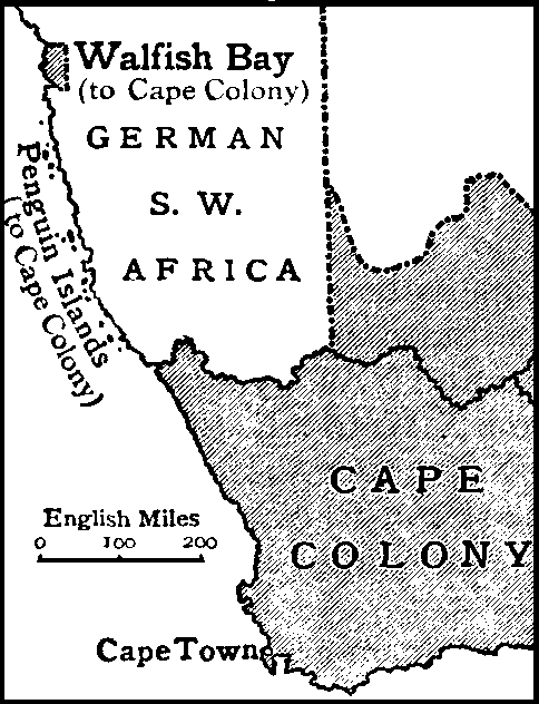
Should you be showing the Penguin Islands off the coast of Namibia, which are although very small, had some political significance belonging to South Africa until recently.
 en.wikipedia.org
Penguin Islands - Wikipedia
So yeah, progress on the river rework in North America! I did got all of Centroamerica and southern Mexico reworks done + cleanned 2 pixels marks I had on the Antilles that I forgot to do last time;
Fun fact: there's 2 sizeable dried lakes on the Campeche state near the border with Yucatan and Quintana Roo borders which I did not find any info on them beyond a physical map of the Yucatan Peninsula and confiming that indeed existed through Google Maps satelite photage, either way they are into the wetland layer now.
Last edited:
Imo only Possession Island (the biggest) deserves to be shown, since the islands together constitute a single political unit and thus showing only one would be enough. Historical South African EEZ can be always shown on a patchShould you be showing the Penguin Islands off the coast of Namibia, which are although very small, had some political significance belonging to South Africa until recently.
I pray for your sanity.Greenland... Nunavut
I updated repository, now we have all up to date patches there. R-QBAM Repository
Up to date as 26 November 2023
Up to date as 26 November 2023
Last edited:
This has helped the project greatly.I updated repository, now we have all up to date patches there. R-QBAM Repository
Also, does anyone here have a 1-degree coordinate grid for this? I know there was a 5-degree grid posted a while back.

I did the 5° coordinate grid way back them, but the 1° I didn't touch at the time because WELL, it's quite a big endevour, here's the source for it if it helps
Exactly what I was looking for, thanks!
I did the 5° coordinate grid way back them, but the 1° I didn't touch at the time because WELL, it's quite a big endevour, here's the source for it if it helps
What are the few dotted red pixels?Update onf the river things: now all of Mexico's rivers reworks are done! Including all of Rio Grande and Colorado basins too + some dry lake redrawing too;
Going to do the US west coast next, so yeah
Well these are markers of the old coastline layer from when I first the North America rivers, since then North America it got a lake rework not so long ago but my river layer is from before that, so I'm just using these red markers to no get lost while updating the riversWhat are the few dotted red pixels?
For once, my estimates for how long a patch would take weren't too far off that mark, with Greenland 1 taking a little over two weeks. I actually finished it yesterday evening, but by that point I didn't have the time or energy to bash out a write-up, so I'm posting it and the patch today instead. Hope you don't mind the brief delay. I was surprised how quickly I made progress; of what I wanted to get done, I had it about 75% done after just a week. The last quarter however dragged on for what felt like ages, though I still powered through it and got it done. Bits of this are still a bit WIP, most notably the coasts at the cut-off point where I'll continue once I get around to Greenland 2. Those areas will definitely receive revisions once I get around to adding the rest of Greenland, but until then I'll just have to make do with something a little provisional.
On a bit of a tangent, I noticed something mildly depressing while making this patch. Older datasets don't quite line up with more recent ones, as the retreat of several glaciers due to global warming has extended the length of a couple of fjords all along the Greenland coast. Mostly it's just a pixel or two, but some have retreated by three or four pixels between datasets that really weren't produced that far apart. The Maldives may not have sunk yet, but the effects of global warming are already visible at the scale of the R-QBAM, which is a sobering thought.
Next up, another big chunk of Brazil, then once that's done in a week or so, back to Canada, adding the first major chunk of Nunavut (Baffin Island, Southampton Island, the Melville Peninsula and plenty of associated smaller islands).
Oh, one last thing. Nice to see progress on the rivers again @Rac98, but I should warn you that I'm seriously considering doing a moderate revision to the coasts and lakes of Quebec and Labrador. I'm happy with the rest of Canada and the US, but something about that area still feels a little bit off to me. I'll probably end up bundling that revision in with the Baffin Island patch I mentioned above, so the wait won't be too long, but Iit might be a good idea to leave that area alone till I've had a chance to go over it again. .
All that out of the way, on with ...
Patch 103 - Greenland 1;
- Added about half of Greenland
Be careful with your source for Greenland and Antarctica! The datasets LOVE to contradict each other there, especially in northern Greenland
I personally trust NASA maps the most, so ig use them as a reference

The region encircled in red is the most distinct feature to compare between datasets for me, it should look almost exactly like that (basically the northern peninsula shouldn't end east of the easternmost point of the peninsula to the south, and the islands to the east should look like that
I personally trust NASA maps the most, so ig use them as a reference
The region encircled in red is the most distinct feature to compare between datasets for me, it should look almost exactly like that (basically the northern peninsula shouldn't end east of the easternmost point of the peninsula to the south, and the islands to the east should look like that
Last edited:
Alright, this wasn't as "simple" as I think would be, but hey the US west coast + about 40% of Bristish Columbia too are done now! So some thoughts on what we have here:
- A minor update on the Colorado basin for the indication of dry rivers, of wich there's many (actually the end of Colorado itself on Mexico is a dry river);
- It taked a while but now I'm sure the Great Basin region pretty complete;
- For some reason my main source for rivers didn't have the river Pit on nothern California, somehow? It wasn't that hard to draw it by "eyemeter", but not gona lie it got me a bit paranoid of possible other missig things... Besides that, beyond the Tulare lake bed the map also shows Buena Vista and Kern lakes too, which I guess are way more forgotten in general;
- I'm surprised on how well I did manage to get Fraser and Columbia basins on Canada when I first did then way back in time, turns out I didn't need much stuff beyond adding the minor rivers to these basins (which well... I survived, I'll explain) + I did do Vancouver Island too;
So here's the update:

Now my next step will be getting British Columbia done, and that will take a little bit of time... Because you see, the Cascadia region is technically an rainforest, and such it has rivers... Lots of rivers... Uhh I didn't thought how annoying that would be, specially considering the projection curve does mess a ton here (actually first time where the projection does complicate things to do rivers to me), thankfully the majority of the river madness is on the BC coast (also extends into the Alaska south coast not present on the map yet but yeah), after that I'll either do Alberta and Saskatchewan then later rework the west side of the Mississippi, or vice-versa IDK.
Also @Tanystropheus42 thanks for talking about this possible rework on the Quebec area, I think by the moment I get to reach there you will have probably figured out if will change something there or not, besides there's still the whole Amazon to do yet eventually... Yeah there's time to that; BTW congrats on Greenland, that fractals may still be a pain but once done sure it's a sight of relief.
- A minor update on the Colorado basin for the indication of dry rivers, of wich there's many (actually the end of Colorado itself on Mexico is a dry river);
- It taked a while but now I'm sure the Great Basin region pretty complete;
- For some reason my main source for rivers didn't have the river Pit on nothern California, somehow? It wasn't that hard to draw it by "eyemeter", but not gona lie it got me a bit paranoid of possible other missig things... Besides that, beyond the Tulare lake bed the map also shows Buena Vista and Kern lakes too, which I guess are way more forgotten in general;
- I'm surprised on how well I did manage to get Fraser and Columbia basins on Canada when I first did then way back in time, turns out I didn't need much stuff beyond adding the minor rivers to these basins (which well... I survived, I'll explain) + I did do Vancouver Island too;
So here's the update:
Now my next step will be getting British Columbia done, and that will take a little bit of time... Because you see, the Cascadia region is technically an rainforest, and such it has rivers... Lots of rivers... Uhh I didn't thought how annoying that would be, specially considering the projection curve does mess a ton here (actually first time where the projection does complicate things to do rivers to me), thankfully the majority of the river madness is on the BC coast (also extends into the Alaska south coast not present on the map yet but yeah), after that I'll either do Alberta and Saskatchewan then later rework the west side of the Mississippi, or vice-versa IDK.
Also @Tanystropheus42 thanks for talking about this possible rework on the Quebec area, I think by the moment I get to reach there you will have probably figured out if will change something there or not, besides there's still the whole Amazon to do yet eventually... Yeah there's time to that; BTW congrats on Greenland, that fractals may still be a pain but once done sure it's a sight of relief.
Share: