You are using an out of date browser. It may not display this or other websites correctly.
You should upgrade or use an alternative browser.
You should upgrade or use an alternative browser.
The Q-BAM Improvement and Core Thread
- Thread starter iori
- Start date


Alex Richards
Donor
First Mexican Empire (1821-1824) with internal divisions.
Belize is claimed, and I outlined Chiapas because it was considered part of Guatemala then but it was about to split.
Claims should be indicated as an outline rather than stripes (that's dual control), and if we have an actual date for the creation of Chiapas then unless there was some sort of autonomous division within the province it really shouldn't be indicated with any sort of border.
Otherwise, looks good.
This is for an alpine update. I changed the czecho-Austrian border as the original more closely matched the old Bohemian-Moravian-Lower Austrian boder. I have added the major lakes of Bavaria, Switzerland, and Austria too. Enjoy!
Oops I forgot the lakes in south Austria. I will get to work on those promptlyView attachment 313936
This is for an alpine update. I changed the czecho-Austrian border as the original more closely matched the old Bohemian-Moravian-Lower Austrian boder. I have added the major lakes of Bavaria, Switzerland, and Austria too. Enjoy!
What
What would you suggest? I only added Lake Zug. The rest are from maps already in the database.
What Monday, March 27, 2017I feel like those Swiss Lakes are getting over the top really.
What would you suggest? I only added Lake Zug. The rest are from maps already in the database.
Alex Richards
Donor
What
What Monday, March 27, 2017
What would you suggest? I only added Lake Zug. The rest are from maps already in the database.
The single pixel wide ones just end up getting in the way if you have subdivision borders IMO.
Alex Richards
Donor
Hmm... You all are so busy hear. Is in this forum a normal thread?
For this sort of thread, yeah it's very much short bursts of activity rather than constant stuff.

Ethnic map of the former USSR from this
to QBAM

And some maps from here http://www.hrono.ru/proekty/ostu/russia.html (I warn you, there may be small inaccuracies)
1462-1505

1st half of the 16th century

2nd half of the 16th century

1600-1648

1648-1682

Rivers (my is dark)

to QBAM
And some maps from here http://www.hrono.ru/proekty/ostu/russia.html (I warn you, there may be small inaccuracies)
1462-1505

1st half of the 16th century
2nd half of the 16th century

1600-1648
1648-1682
Rivers (my is dark)
Are these maps done accurate?Ethnic map of the former USSR from this
to QBAM
View attachment 315398
And some maps from here http://www.hrono.ru/proekty/ostu/russia.html (I warn you, there may be small inaccuracies)
1462-1505
View attachment 315400
1st half of the 16th century
View attachment 315401
2nd half of the 16th century
View attachment 315402
1600-1648
View attachment 315403
1648-1682
View attachment 315404
Rivers (my is dark)
View attachment 315405
Inaccuracies in several places on original maps, their transfer to the QBAM is accurate within the inaccuracy of the QBAM themselves. For example, you can see the great curvature of the Don, but it lies exactly in the corresponding districts of Rostov and other regions, I set myself the task of transferring to an existing QBAM, and not a correction of QBAM itself. Also I did not correct the inaccuracy of the originals, I think they are insignificant, considering that this is a map of time periods, rather than a specific years.Are these maps done accurate?
Proposed fix for 1946 map
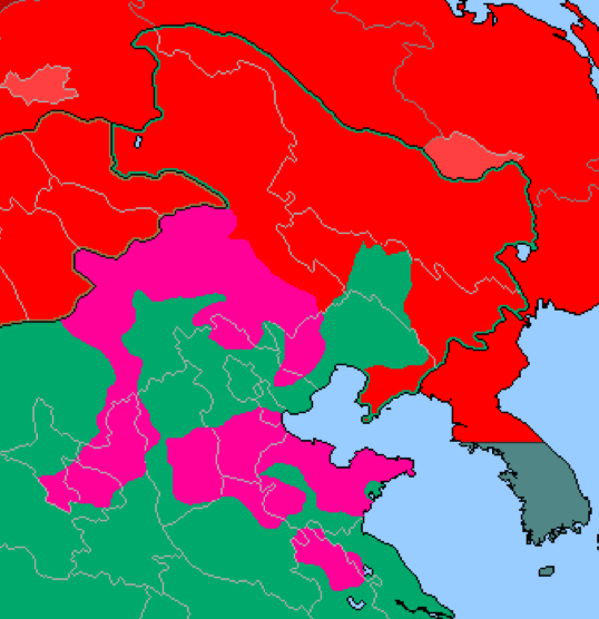
- Soviet Union occupied Manchuria until May 1946. In the Sino-Soviet Treaty of Friendship and Alliance: Manchuria was promised to Republic of China, yet it was secretly handed over to the Communist
- Fixed Korea, moved 38th up a bit, as South Korea owned Ongjin before the war
- I believe I fixed the Northern front of China to be more accurate
Last edited:
NIGER PATCH
While working on Niger river, I realised that Niger subdivisions were slightly off (just a little), so I did a small patch(not that the old version version was bad) and well, here it is:
View attachment 245766
They lack provinces.
Share: