I currently live in a corner of what meteorologists call "Tornado Alley", and to be honest, I am getting fed up with hiding in bathrooms while the Reaper's Scythe spirals through my home town and threatens to undo years of hard work in one blow. At the same time, I live somewhere between the "mixed grass" and "tallgrass" prairies of the Midwest, so I'm not terribly fond of the idea of living in deserts. (I mean, come on, sunburn? Eye damage? No water? Threat of heat stroke in the middle of retail? Being forced to put on sunscreen that, for whatthehellever reason, worsens the sweating sensation? Who would want to live under THOSE conditions?)
The key to both factors is the Rocky Mountains, so how could I change them to reduce the size of Tornado Alley without sacrificing the Midwest's prairie fertility in the process? Here are four options:
There are other factors involved in this, using the following combination:


After all that has been said and done, which of these four alternatives is the best option to get rid of Tornado Alley and keep the Midwest's prairie fertility?
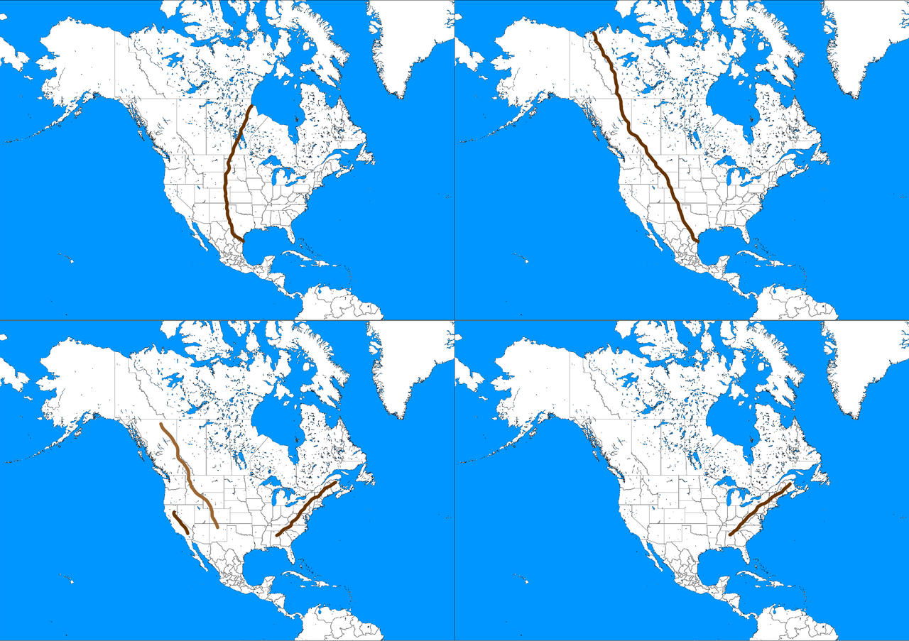
The key to both factors is the Rocky Mountains, so how could I change them to reduce the size of Tornado Alley without sacrificing the Midwest's prairie fertility in the process? Here are four options:
- Top left, the currently accepted alternative, in which the Rockies make a sort of waning crescent curve from Matamoros, Mexico, all the way to Churchill, Canada. Maximum elevation above sea level--20,310 feet. This, and the fact that the mountain range curves from sea to sea, were, so I believe, crucial to not completing the recipe that makes Tornado Alley possible.
- Top right, in which the Rockies are arranged just the same as back home, except that now they extend from coast to coast, creating what is essentially a "complete wall". Maximum elevation above sea level--20,310 feet.
- Bottom left, in which the heights of the two major mountain ranges--the Rockies and the Appalachians--are reversed. Now the Appalachians are more mountainous, maximum elevation above sea level anywhere between 14,440 feet and 20,310 feet, depending on how much uplift the particular numbers would result in, whereas the Rockies are now 2,037-6,684 feet above sea level maximum. Same goes for the other mountain ranges between the Rockies and the Pacific coastline, in which their measurements in meters have been downsized into feet. (For example, turning Mount Whitney, the Sierra Nevada's highest peak, from 4,421 meters above sea level to 4,421 feet.)
- Bottom right, in which there are only the Appalachians, standing at anywhere between 14,440 feet and 20,310 feet above sea level maximum, depending on how much uplift the particular numbers would result in.
There are other factors involved in this, using the following combination:
After all that has been said and done, which of these four alternatives is the best option to get rid of Tornado Alley and keep the Midwest's prairie fertility?