My brother lived in PNG for over 12 months, mainly on the North Coast during the 1970s. It was apparently quite hairy flying from there to Port Moresby on the South Coast by light aircraft that were often barely able to clear the Owen Stanleys. He recounted one flight where they loaded a fully grown Bull Salt-water Crocodile over 5 metres in length down the central aisle of the aircraft. It was doped up but even so, it started waking up mid-flight and started to flex in the confined conditions. The aircraft apparently creaked quite a bit! Now that was unusual and definitely wouldn't have been repeated in 1942, but it gives you some idea of what it was like up there.It still is recently an airlines png twin otter crashed flying into kokoda
You are using an out of date browser. It may not display this or other websites correctly.
You should upgrade or use an alternative browser.
You should upgrade or use an alternative browser.
Malaya What If
- Thread starter Fatboy Coxy
- Start date
Threadmarks
View all 264 threadmarks
Reader mode
Reader mode
Recent threadmarks
MWI 41120514d Royal Navy Eastern Fleet OOB MWI 41120618 Shuffling The Pack MWI 41120617 The Ongoing Development Of The Airfields MWI 41120617a RAF Far East Command MWI 41120618 Rommel Retreats To The Gazala Line MWI 41120619 Kondo’s Dilemma MWI 41120620 Matador Is On MWI 41120702 The Race Begins
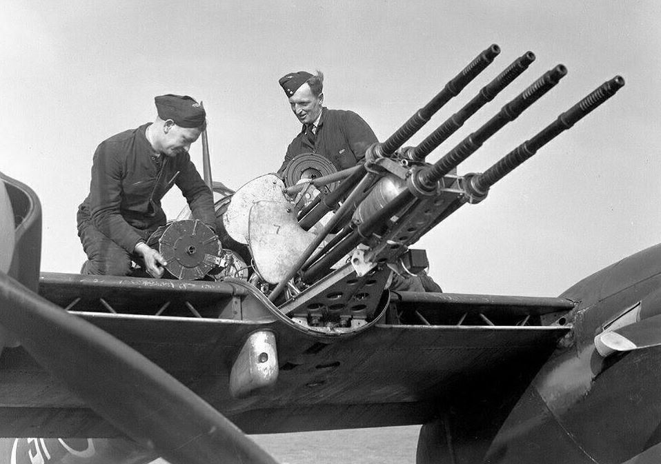
Bristol Bisley prototype first flown in February 1941, No belly pack, solid nose with four machine guns, very clean at this stage of development.
Fitting AI would increase the drag but this would IMVHO be a very useful night fighter in Malaya in late 1941.
Now have some bright-spark decide to graft the four cannon mounting from a Whirlwind into this solid nose and any Japanese aircraft that gets hit will have a very torrid
time!
Fatboy Coxy
Monthly Donor
Hi Ihagambia, yes formed in Singapore, it's really just a renumbering of RAF 243 Sqn, providing more identity to the Kiwi contributionIn the OTL, 486 Squadron RNZAF wasn't formed until March 1942 taking part in the idiotic Turbinlite programme. In this timeline is it formed in Singapore?
Kiwis are very proud of 486's efforts against V1s in 1944, I'm guess an extended campaign in Malaya is going to change all of that.
http://www.historyofwar.org/air/units/RNZAF/No_486_sqn_RNZAF.html
Fatboy Coxy
Monthly Donor
Hi Vetinari, love this story of the crocodile!My brother lived in PNG for over 12 months, mainly on the North Coast during the 1970s. It was apparently quite hairy flying from there to Port Moresby on the South Coast by light aircraft that were often barely able to clear the Owen Stanleys. He recounted one flight where they loaded a fully grown Bull Salt-water Crocodile over 5 metres in length down the central aisle of the aircraft. It was doped up but even so, it started waking up mid-flight and started to flex in the confined conditions. The aircraft apparently creaked quite a bit! Now that was unusual and definitely wouldn't have been repeated in 1942, but it gives you some idea of what it was like up there.
Even with GPS telling you exactly where you are the old traps are still waiting. That's awful.It still is recently an airlines png twin otter crashed flying into kokoda
Yes in 1941 Torpedoes are some of the most expensive and complex weapon systems then in existenceAs a piece of reference. The 20,000 lbs of USN aerial munitions stored at Singapore Naval Base, were heavier bombs (250-1,000lb) and Depth charges. No torpedoes were included. All can be handled by PBYs the British have.
A bomb and a depth charge are staggeringly simple by comparison and to store your best weapons in another nations base would require USN maintenance armorers to be present there.
Also 20,000 lbs is not a lot of weapons
The RAAF regularly used to conduct training on Carabou transport aircraft into the Owen Stanleys. There was one village airstrip that was a real test apparently. It went up hill on a ridge and was at right angles to the valley. Apparently they had to approach it and then turn sharply unto the runway and grind to a quick stop. It was apparently quite a test and was given to new pilots so they could, "prove their worth". Most made it, a few didn't. The old hands could do it in a DC-3, which was before the adoption of the Carabou.Even with GPS telling you exactly where you are the old traps are still waiting. That's awful.
The "old traps" including rain that is locally heavy enough to change the air through which the plane flies into a much heavier gas-liquid mix that would require a very different "aerofoil" to generate lift; and rain that is locally heavy enough to interfere with combustion air intake and cause engine stall; and unpredictable downdrafts, rapid velocity shifts and spiraling turbulence as pressure-front air mass flows are squeezed through the same mountain notches that you're trying to fly through...all of which can result in intersecting the ground even though you know exactly where it is.Even with GPS telling you exactly where you are the old traps are still waiting. That's awful.
The only significant difference from WWII is that WWII pilots *didn't* know exactly where the ground was...they just knew it wasn't far away, down, left and right.
OTL, Singapore was Hart's preferred fall back base. Hart suffered a massive insufficiency in fleet train. He had one large seaplane tender ,the Langley, that at times served also as an aircraft transport,which could handle 12 aircraft, 2 converted destroyers each capable og handling 4 Aircraft,,and a converted mine craft capable of handling 4 aircraft. Hart had 28 PBYs. 5 J2Fs, 5 SOC-3, and 1 OS2U.Yes in 1941 Torpedoes are some of the most expensive and complex weapon systems then in existence
A bomb and a depth charge are staggeringly simple by comparison and to store your best weapons in another nations base would require USN maintenance armorers to be present there.
Also 20,000 lbs is not a lot of weapons
Hart moved those munitions because his Tenders were full. He had also 1 destroyer tender, 3 submarine Tenders, ( one a converted cargo ship) and 2 oilers.
MWI 41120618 Rommel Retreats To The Gazala Line
Fatboy Coxy
Monthly Donor
1941 Saturday 06 December;
Its taped headlights lighting the way through the darkness, the Opel Blitz picked its path along the dirt road heading north to the military hospital in Dena, its white painted roof and big red cross marking it out as an ambulance. Inside, strapped on a hanging bunk, lay Generalmajor Walter Neumann-Silkow, commander of 15th Panzer Division, barely alive, heavily sedated with morphine, a shell splinter having shattered his mandible over an hour ago. 15th Panzer had failed to push the British 22nd Guards Brigade away from Bir El Gubi that afternoon, although their arrival earlier, along with 21st Panzer Division, had stopped the British forces advancing north to El Adem to cut off the Axis forces. Indeed, the British still hadn’t yet taken Strongpoint 182. The Italian Blackshirts there had repulsed all attacks since Wednesday.
The weather had improved, and yesterday had seen the beginning of heavy air activity from both sides. The Luftwaffe attacked British positions around Bir El Gubi, sparking many dogfights as British fighters sought to break up these attacks. There was a steady loss of German bombers, but the British were losing a lot of fighters, having nothing to match the Me 109F, who rate of climb and speed was noticeably better. Nevertheless, the RAF was making its own presence known. British medium bombers and Hurricane fighter-bombers attacked Axis traffic withdrawing past El Adem during the day. Wellingtons and FAA Albacores attacked the road from El Adem to Gazala by night, assisted by nightly bombardments from the Royal Navy’s Insect class gunboat Aphis.
For the troops on the ground, things had become very confusing, with Allied and Axis forces often mixed up, and having difficulty identifying one another, owing to the general practice of using captured vehicles and the camouflage effect of the all-covering dust and sand. Axis forces were facing low supplies of fuel, ammunition, and food, impacting on their performance, along with the exhaustion of the troops. The British were somewhat better off on the ground, but their commander, Ritchie, was hesitant, despite Allied intelligence telling him Rommel was retreating, and unsure where both his and Rommel’s forces were. For now, he was being guided by his two corps commanders, who had a better local feel for the battlefield.
For Rommel, the day's events confirmed that his only realistic option was retreat, as staying would quickly become a defeat in detail. He ordered some of the artillery and Lt Gen Navarini’s XXI Italian Infantry Corps HQ back to Gazala. He planned to use the old disused Gazala defensive line, with the four Italian infantry divisions in the line, the mobile Italian XX Corps on their southern flank, and echeloned back, the DAK. For his forces embedded in the frontier defensive fortifications, the order would be to hold on and buy time: there was no realistic prospect of relief. The rest of his forces would all begin their withdrawal tomorrow. Great skill would be required to make a fighting retreat, and not a rout, delaying the British advance with guile and misinformation as to Axis intentions.
...rain that is locally heavy...
Modern weather-analysis consumers are familiar with the term "atmospheric river", describing a multi-year-cyclic weather phenomenon, a key element of climatological mechanics, in which water is evaporated from oceans in warm locales, then moved long distances to fall as heavy rain. In "El Nino" periods, a Pacific atmospheric river dumps rain on the southwestern and central-southern USA. Much of that water originates north of Papua New Guinea, in a band from the northwest extending eastward....pressure-front air mass flows are squeezed through the same mountain notches that you're trying to fly through...
Warm high-evaporation oceanic regions like this have measurably higher surface salinity, which can be determined via satellite measurement of infrared emission characteristics. This is a recent salinity map for the Pacific Ocean. Red areas are higher salinity because of lower rainfall and high sunlight evaporation, blue ones are where it rains a lot and surface salinity is lower:

USA isn't the only place affected by the "atmospheric river" phenomenon. Currently Australia has two...one affecting western Australia, originating in the Indian Ocean, and not of immediate interest to this thread, and the other affecting eastern Australia, and of direct interest. That second "atmospheric river" has been estimated to have a water flow rate of about 600 Murray Rivers. Murray River is the longest river in Australia, and is pretty good sized, so that's a lot of water. Most of the evaporated warm water from north of PNG, and the immense amount of thermal energy it contains, flows eastward into the Coral Sea. Some continues across the Pacific to be a dominant factor in the weather of much of North America, but the rest feeds a circulation path that rotates around PNG, and...normally...sends massive air-water-and-energy flows through the valleys of the Owen Stanleys. That's the driver for the daily thunderstorms and frequent rain squalls around the peaks and up and down the valleys.
Note the deep blue along much of the southern coast of PNG. The same infrared methods cannot measure rainfall on land, but the rain rates in the Owen Stanleys are *much higher* than over the sea, as the massive amount of warm water in the airflow collides with the mountains and generates thunderstorms.
Right now, there's a low pressure zone over central Australia, stuck there because a high pressure zone in front of it is stalled. That's causing a sizeable part of the southern fork of the "atmospheric river" from the Coral Sea that normally circulates westward around, and then northward across PNG to be attracted to that low, and wrap clockwise around it as it bends far to the south, and drop massive amounts of rain over eastern Australia.

My understanding is that during the WWII years, weather patterns across the Coral Sea and the land to its west...PNG...were more conventional. The warm water north of PNG, indirectly and circuitously, drove the atrocious wet weather in the Owen Stanleys via moisture and thermal energy wrapping back from the Coral Sea, and eastern Australia had moderate, temperate weather.
Last edited:
Not always. The global wind circulations cause the trade winds in the lower latitudes (the tropical zones) to be easterlies, so weather generally goes east to west there.Generally weather proceeds from west to east. Weather only goes one way, round the Earth.
From this site:
Near the earth's surface at tropical (low) latitudes, the prevailing wind is from the east. These are called easterlies, and are also known as the trade winds. Embedded within this general flow can be tropical cyclones (hurricanes, typhoons), which are also initially blown from east to west by the prevailing easterlies.
See also this page for an overview of the global circulation.Fatboy Coxy
Monthly Donor
Hi JWilly48519, that's really interesting stuff, but can I ask if you can tailor it a little more towards peninsular Malaysia, I asked about the Owen Stanley mountains to provide some comparison to those in Malaya, but on reflection, the Owen Stanley range is much higher. What I'm interested in is whether there is any real problem flying across Malaya, over the mountain range.Modern weather-analysis consumers are familiar with the term "atmospheric river", describing a multi-year-cyclic weather phenomenon, a key element of climatological mechanics, in which water is evaporated from oceans in warm locales, then moved long distances to fall as heavy rain. In "El Nino" periods, a Pacific atmospheric river dumps rain on the southwestern and central-southern USA. Much of that water originates north of Papua New Guinea, in a band from the northwest extending eastward.
Warm high-evaporation oceanic regions like this have measurably higher surface salinity, which can be determined via satellite measurement of infrared emission characteristics. This is a recent salinity map for the Pacific Ocean. Red areas are higher salinity because of lower rainfall and high sunlight evaporation, blue ones are where it rains a lot and surface salinity is lower:
USA isn't the only place affected by the "atmospheric river" phenomenon. Currently Australia has two...one affecting western Australia, originating in the Indian Ocean, and not of immediate interest to this thread, and the other affecting eastern Australia, and of direct interest. That second "atmospheric river" has been estimated to have a water flow rate of about 600 Murray Rivers. Murray River is the longest river in Australia, and is pretty good sized, so that's a lot of water. Most of the evaporated warm water from north of PNG, and the immense amount of thermal energy it contains, flows eastward into the Coral Sea. Some continues across the Pacific to be a dominant factor in the weather of much of North America, but the rest feeds a circulation path that rotates around PNG, and...normally...sends massive air-water-and-energy flows through the valleys of the Owen Stanleys. That's the driver for the daily thunderstorms and frequent rain squalls around the peaks and up and down the valleys.
Note the deep blue along much of the southern coast of PNG. The same infrared methods cannot measure rainfall on land, but the rain rates in the Owen Stanleys are *much higher* than over the sea, as the massive amount of warm water in the airflow collides with the mountains and generates thunderstorms.
Right now, there's a low pressure zone over central Australia, stuck there because a high pressure zone in front of it is stalled. That's causing a sizeable part of the southern fork of the "atmospheric river" from the Coral Sea that normally circulates westward around, and then northward across PNG to be attracted to that low, and wrap clockwise around it as it bends far to the south, and drop massive amounts of rain over eastern Australia.
My understanding is that during the WWII years, weather patterns across the Coral Sea and the land to its west...PNG...were more conventional. The warm water north of PNG, indirectly and circuitously, drove the atrocious wet weather in the Owen Stanleys via moisture and thermal energy wrapping back from the Coral Sea, and eastern Australia had moderate, temperate weather.
I take it this is no change to OTL?1941 Saturday 06 December;
Its taped headlights lighting the way through the darkness, the Opel Blitz picked its path along the dirt road heading north to the military hospital in Dena, its white painted roof and big red cross marking it out as an ambulance. Inside, strapped on a hanging bunk, lay Generalmajor Walter Neumann-Silkow, commander of 15th Panzer Division, barely alive, heavily sedated with morphine, a shell splinter having shattered his mandible over an hour ago. 15th Panzer had failed to push the British 22nd Guards Brigade away from Bir El Gubi that afternoon, although their arrival earlier, along with 21st Panzer Division, had stopped the British forces advancing north to El Adem to cut off the Axis forces. Indeed, the British still hadn’t yet taken Strongpoint 182. The Italian Blackshirts there had repulsed all attacks since Wednesday.
The weather had improved, and yesterday had seen the beginning of heavy air activity from both sides. The Luftwaffe attacked British positions around Bir El Gubi, sparking many dogfights as British fighters sought to break up these attacks. There was a steady loss of German bombers, but the British were losing a lot of fighters, having nothing to match the Me 109F, who rate of climb and speed was noticeably better. Nevertheless, the RAF was making its own presence known. British medium bombers and Hurricane fighter-bombers attacked Axis traffic withdrawing past El Adem during the day. Wellingtons and FAA Albacores attacked the road from El Adem to Gazala by night, assisted by nightly bombardments from the Royal Navy’s Insect class gunboat Aphis.
For the troops on the ground, things had become very confusing, with Allied and Axis forces often mixed up, and having difficulty identifying one another, owing to the general practice of using captured vehicles and the camouflage effect of the all-covering dust and sand. Axis forces were facing low supplies of fuel, ammunition, and food, impacting on their performance, along with the exhaustion of the troops. The British were somewhat better off on the ground, but their commander, Ritchie, was hesitant, despite Allied intelligence telling him Rommel was retreating, and unsure where both his and Rommel’s forces were. For now, he was being guided by his two corps commanders, who had a better local feel for the battlefield.
For Rommel, the day's events confirmed that his only realistic option was retreat, as staying would quickly become a defeat in detail. He ordered some of the artillery and Lt Gen Navarini’s XXI Italian Infantry Corps HQ back to Gazala. He planned to use the old disused Gazala defensive line, with the four Italian infantry divisions in the line, the mobile Italian XX Corps on their southern flank, and echeloned back, the DAK. For his forces embedded in the frontier defensive fortifications, the order would be to hold on and buy time: there was no realistic prospect of relief. The rest of his forces would all begin their withdrawal tomorrow. Great skill would be required to make a fighting retreat, and not a rout, delaying the British advance with guile and misinformation as to Axis intentions.
Regarding flying over mountains.
This fine if everything is working as most WW2 front line aircraft would have no issues flying over most mountain ranges - but if a given aircraft suffers a power loss and is obliged to descend - then its a problem.
And aircraft still fly into mountains and hills to this day!
This fine if everything is working as most WW2 front line aircraft would have no issues flying over most mountain ranges - but if a given aircraft suffers a power loss and is obliged to descend - then its a problem.
And aircraft still fly into mountains and hills to this day!
Driftless
Donor
1941 Saturday 06 December;
Its taped headlights lighting the way through the darkness, the Opel Blitz picked its path along the dirt road heading north to the military hospital in Dena, its white painted roof and big red cross marking it out as an ambulance. Inside, strapped on a hanging bunk, lay Generalmajor Walter Neumann-Silkow, commander of 15th Panzer Division, barely alive, heavily sedated with morphine, a shell splinter having shattered his mandible over an hour ago. 15th Panzer had failed to push the British 22nd Guards Brigade away from Bir El Gubi that afternoon, although their arrival earlier, along with 21st Panzer Division, had stopped the British forces advancing north to El Adem to cut off the Axis forces. Indeed, the British still hadn’t yet taken Strongpoint 182. The Italian Blackshirts there had repulsed all attacks since Wednesday.
The weather had improved, and yesterday had seen the beginning of heavy air activity from both sides. The Luftwaffe attacked British positions around Bir El Gubi, sparking many dogfights as British fighters sought to break up these attacks. There was a steady loss of German bombers, but the British were losing a lot of fighters, having nothing to match the Me 109F, who rate of climb and speed was noticeably better. Nevertheless, the RAF was making its own presence known. British medium bombers and Hurricane fighter-bombers attacked Axis traffic withdrawing past El Adem during the day. Wellingtons and FAA Albacores attacked the road from El Adem to Gazala by night, assisted by nightly bombardments from the Royal Navy’s Insect class gunboat Aphis.
For the troops on the ground, things had become very confusing, with Allied and Axis forces often mixed up, and having difficulty identifying one another, owing to the general practice of using captured vehicles and the camouflage effect of the all-covering dust and sand. Axis forces were facing low supplies of fuel, ammunition, and food, impacting on their performance, along with the exhaustion of the troops. The British were somewhat better off on the ground, but their commander, Ritchie, was hesitant, despite Allied intelligence telling him Rommel was retreating, and unsure where both his and Rommel’s forces were. For now, he was being guided by his two corps commanders, who had a better local feel for the battlefield.
For Rommel, the day's events confirmed that his only realistic option was retreat, as staying would quickly become a defeat in detail. He ordered some of the artillery and Lt Gen Navarini’s XXI Italian Infantry Corps HQ back to Gazala. He planned to use the old disused Gazala defensive line, with the four Italian infantry divisions in the line, the mobile Italian XX Corps on their southern flank, and echeloned back, the DAK. For his forces embedded in the frontier defensive fortifications, the order would be to hold on and buy time: there was no realistic prospect of relief. The rest of his forces would all begin their withdrawal tomorrow. Great skill would be required to make a fighting retreat, and not a rout, delaying the British advance with guile and misinformation as to Axis intentions.
A reminder that there is desperate and large scale fighting going on thousands of miles away in North Africa? That (to this point), its more of an ominous threat in Southeast Asia, and from a different enemy?
Threadmarks
View all 264 threadmarks
Reader mode
Reader mode
Recent threadmarks
MWI 41120514d Royal Navy Eastern Fleet OOB MWI 41120618 Shuffling The Pack MWI 41120617 The Ongoing Development Of The Airfields MWI 41120617a RAF Far East Command MWI 41120618 Rommel Retreats To The Gazala Line MWI 41120619 Kondo’s Dilemma MWI 41120620 Matador Is On MWI 41120702 The Race Begins
Share: