This is an old revision of the document!
High Kingdom of Manticore
The basic premise of this setting is that the Rockall Bank was pushed up above sea level between 25 and 35 million years ago, forming a large and rather mountainous island to the northwest of the British Isles. This idea was originally mine (not that other people thought of it before me), but the setting has since been influenced by a wide variety of ATLs, including the Tarrantry stories and the Tol Galen AU on Shipbucket.
Geography

The history of Calendor begins roughly four to five thousand years ago with the arrival of the Sindar from the European mainland. These are essentially my version of Tolkien's Sindar elves transported into the world of Manticore. My version of the elven migration begins in the northern reaches of the Ural Mountains among the predecessors of what are now the Finno-Ugric peoples of Finland and Hungary. The Sindar migrated through what are now Russia, Germany, and the Low Countries before taking to the sea and travelling first to Britain and then Ireland before crossing open Atlantic to the island they named Calendor.
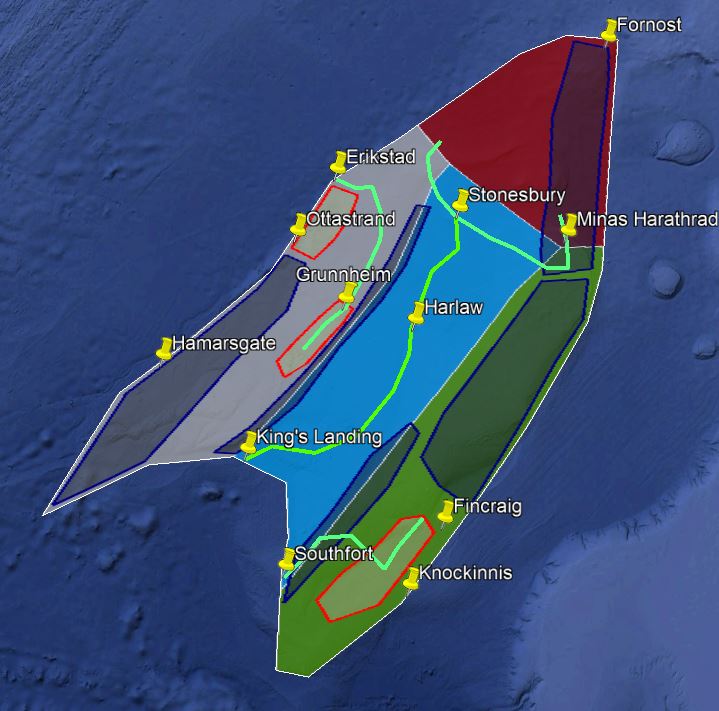
For almost two thousand years, the Sindar tribes ruled Calendor by themselves. Although their written language was limited to runes and their agriculture remained relatively undeveloped, the relatively peaceful coexistence of the Sindar tribes meant that they were able to expend huge amounts of wealth and resources on massive building projects that still dominate some of Calendor's most prominent geographic landmarks. The fairly sudden climatic cooling in the centuries before the Medieval Warm Period weakened the warm-weather agricultural package the Sindar used in the southern regions of Calendor and allowed the incremental colonization of the southeast coast by Goidelic Celts from Ireland beginning in the 7th and 8th centuries. Further outside colonization of Calendor occurred in the 9th and 10th centuries by Anglo-Saxon raiders landing on the southeast coast (the concave part) and Norse Vikings landing on the northwest coast in the 10th and 11th centuries. Over these centuries, the Sindar were pushed further and further north until the island reached a new equilibrium point as shown in the map above.
