Table of Contents
Resources : Wales
This is a page listing various resources dealing with Welsh history, geography and related topics and subjects. Resources range from website and online article links to lists of recommended non-fiction bibliography.
Maps
Map of polities in post-Roman Wales
Basic map of medieval kingdoms and states of Wales
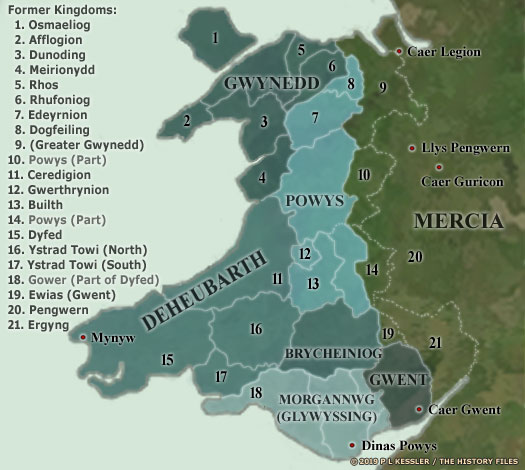
Coloured map of medieval kingdoms and states of Wales
Map of the Kingdom of Gwynedd in ca. 620
Map of the Kingdom of Gwynedd in ca. 830
Principal administrative divisions of medieval Gwynedd (traditional territorial extent)
Map of cantrefi (land divisions) in medieval Wales
Map of Wales in ca. 1217 - Yellow: Areas directly ruled by Llywelyn; Grey: Areas ruled by Llywelyn's vassals; Green: Anglo-Norman marcher lordships in Wales.
Map of the Principality of Wales after the Statute of Rhuddlan (1284) - Green: Former principality of Gwynedd with counties created by the Statute of Ruddlan; Cyan: Counties created by the Statute of Ruddlan; Orange: Lordships of the Marcher barons.
Archives and Documents
Cronfa Ddata Enwau Lleoedd / Archif Melville Richards - Online searchable database of the place names of Wales from the University of Wales at Bangor's Place-Name Research Centre. Provides alternate historical spellings, historic references, dates, and most importantly the exact sources in which these place name references are found.
Historiography and Culture
Honours of the Principality of Wales
Castlewales.com - Comprehensive overview of Welsh castles.
The situation in Wales between 800 and 1000 AD
See Also
Wales / Britain / The United Kingdom
Useful Resources about the United Kingdom
British Timelines and Scenarios