WIP Map Thread

1651519997038.png


This is a map of the known world of the Kihan, a race of intelligent troodontid dinosaurs that evolved just in time for their Iron Age civilisation to be wiped out by the Chicxulub impactor. This is 66 million years ago, and the central continent is Asia, the continent in the northwest is Europe, and the "turn back etc etc" coast in the south is India.
Still have to make a legend and a write-up, thoughts?
 
Some more progress on my "Viking Age of Piracy" map. I originally had Sweden extending all the way to the Pacific, basically as Russia did OTL by this point, but I figured they might be less inclined to spread east with their noses more firmly in European affairs. Unclear borders are denoted with a darker outline of the country's colour, or the "generic" colour, which amounts to a lot of the world really. Africa is mostly blank not because I consider it personally unimportant, but because none of the great African empires of OTL have much signficance to the timeline (I'll be 'blanking' a lot of Europe's small states too).

I was tempted to fuse Korea and Mongolia, but I couldn't think of a compelling reason as to why it would happen. The southern border is at the Great Wall (approximately). Japan will be a vassal of Korea, and maybe a handful of smaller areas too.

Crimea/Ukraine is firmly Turkic ethnically and linguistically but is steadily being "Europeanised" in terms of culture, whatever that means in this world (without a strong unified Church "European" has a less unifying function; Moravia, for example, is still firmly "Slavic" in culture with all that entails, adhering to Slavic holidays and traditions).

I've also added some Anglish "trekker" states in the Appalachians. The eastern seaboard of North America was Anglish, but when the Franks conquered Angland it was briefly a collection of independent earldoms before the Franks got to them. A bunch fled to the Danish colonies (as explained in my last post) and turned to piracy, a bunch fled into the mountains. Expect some kind of American version of the Boer Wars at some point in the future.
1651647865428.png
 
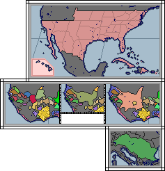
Making a kinda "warlord" era of a collapsed Federal government with its successor being the Union Government in the Eastern Coast.
export202205042132109560.png
 
This is a map of the known world of the Kihan, a race of intelligent troodontid dinosaurs that evolved just in time for their Iron Age civilisation to be wiped out by the Chicxulub impactor. This is 66 million years ago, and the central continent is Asia, the continent in the northwest is Europe, and the "turn back etc etc" coast in the south is India.
Still have to make a legend and a write-up, thoughts?
It makes me really want to know more. What map background did you use?
It would also be fun (but very time-consuming) to make an "alternate prehistory" timeline, that would be original and could please.
 
It makes me really want to know more. What map background did you use?
It would also be fun (but very time-consuming) to make an "alternate prehistory" timeline, that would be original and could please.

Thanks! If you're referring to the basemap, I painstakingly eyeballed it (with the help of latitude and longitude lines) from this 65 Mya mollweide map on deeptimemaps.com.
I do plan on making a timeline at some point, along with exploring the fate of the last few Kihan as they try to survive the years after the K-T impact.
 
Modern Greece, medieval Greece (Byzantines), Gambia and Germany... right? (which looks to be the Second Reich - Nazis or early-modern Germany too unappealing?)
Supposed to be Alexandrian Greece: I was afraid it would look too Byzantine, and it seems like I was right. :biggrin:

Everybody has done Nazi Germany, often multiple times. I'm also thinking of doing Different Medieval Migrations Germany.
 
The Crown and the Sword Europe WIP.png

New project of mine, a medieval alt-crusades setting set around 1220. I'm liking how Europe's turned out, now to figure out the Middle East and Russia.
 
1652126092786.png

I'm not sure how much further I'll go with this concept but I thought I'd try my hand at making a map of modern Europe in the aftermath of a Napoleonic victory. This map in particular is meant to show the member states of an EU-analogue led by France and Austria. Like with the British map I posted in the main map thread, there's definitely a lot of "rule of cool" involved over strict plausibility, but that being said I'm still very open to feedback about how the scenario could be better. In particular, I wasn't sure about the following aspects:

  • Germany: I didn't want to keep the Confederation of the Rhine or have a united Germany, but at the same time I did want to consolidate the German realms so that there weren't too many tiny city states or egregious border gore. I'm mostly content with how the German states turned out but I wasn't sure if there was a better way to have Germany consolidated into just a few important kingdoms and duchies.
  • Eastern Europe: As you can probably tell, I lifted a lot of the borders in Eastern Europe from WW1-era borders, particularly the borders and claims following the Brest-Litovsk treaty as well as the general situation of the Balkans at that point, with only a few variations. My main idea is that there was some sort of Russian collapse in the 20th century that allowed for the French/Austrians to come in and establish new client states (with Russia beforehand still being a strong power in on-and-off opposition with the French), but that being said the borders also seem very convergent for a POD over a century prior. If anyone has any better suggestions for eastern borders I'm all ears. There's also Greece; I didn't want to go full Megali Idea or neo-Byzantium, but I did like the idea of them at some point regaining Constantinople. That being said I don't know how good those specific borders are, and I'm open to criticism there.
  • Scandinavia: I'm really not sure whether I should keep Denmark-Norway intact, have Norway be an independent kingdom, or just have a unified Scandinavia in the vein of OTL Germany or Italy. There's also the matter of Finland's eastern borders; as I said, I envision Russia collapsing and various client states being established, but do Finland's borders make sense or should they be bigger/smaller?

I'm also somewhat interested in making this a more stylized map with a legend and other aesthetic features, but I've never done that before (at least not very well) so I'd appreciate any advice anyone may have on that front.
 
image_2022-05-11_01-33-18.png


Got some new martian states for yall, with even some pixel rendering of their flags. Gordee on the coast and Poynting inland. Gordee's flag featuring a knot representing the Gordian Knot, for which the ridge that forms their western border is named. Poynting's flag features a stylized depiction of Poynting Vectors, one of the innovations of the physicist for whom the central creater that names the state was given it's name, John Poynting.
 
1652400228927.png

the startage of some generic post ww3/nukes/suprisingly not yellowstone (specifically not this due to plans for the region) loosely based on the after the end mod for ck2. thoughts?
 
Top