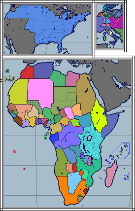
An alternate cold war world rather loosely inspired by the Jour J story "Paris, Secteur Soviétique", although this is ultimately best thought of as a general 'Soviets do rather better' world. Swindling more lend-lease aid from the USA, Tukhachevsky surviving the purge, and most importantly of all, bypassing plenty of cities versus uselessly sieging them did wonders for the Soviet advance, to say nothing of all the beach landings on D-Day going akin to Omaha Beach OTL. The year for this map is oh, about 1956-1958 or so, a few years after when the original comic story took place. It goes without saying that the West will have a rather harder time than it did OTL, and the world will be poorer for it, literally and metaphorically. I do feel the need to say my writeup for this world will have some key details different than what the comic story implied for its version. Going to have the Eiffel Tower fully surviving for starters...
My main questions for the map are if I should have 1) divided Italy along the city of Rome and Tiber River much as Paris was divided along the Seine in France, but leaning no... having both cities divided like that would be too gimmicky, 2) if all of Korea should fall to the communists, and leaning yes for that one, and 3) if I should make it a full world map, but given how most of the world would be the cyan "no self rule" color and the Rio Pact would probably need its own shade of blue, I see no point at the moment. I like the focus kept on the main alliances in Europe anyway. I would like to make a map set further in the future of this world, and given how mixed up the various world alliances in the decolonized third world will be, I'll do it then.
It's a very basic scenario on the normal WorldA map, but even so, comments, questions, and criticism are all still welcome.