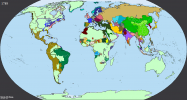
Maria Theresa take her revenge on Fritz, whose kingdom was stripped of everything apart of Brandenburg itself and part of Pomerania. Sweden reclaim Stettin, Russia took Prussia (and switch for Courland), Saxony Magdeburg. Luxembourg was going to Bourbon prince of Parma, while another french prince take Pomerania-Stolp (and later polish crown).
Later, without prussian opposition, Habsburgs cut deal with Wittelsbachs and get Bavaria, while former rulers of it had buffer state between Germany and France on lower Rhine (former A. Netherland, Pfalz, Berg and former prussian territories there).
There was still a war with Ottomans, but here, Austria was doing better and get Belgrade and "Turkish Croatia".
Outside of Europe I know just that France was stil defeated in colonies (but slightly less than OTL, I guess?) and there was still american revolution (not on the map, yet)
Any ideas?
