You are using an out of date browser. It may not display this or other websites correctly.
You should upgrade or use an alternative browser.
You should upgrade or use an alternative browser.
WIP Map Thread
- Thread starter B-29_Bomber
- Start date
-
- Tags
- work in progress
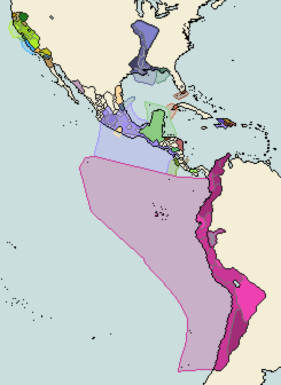
2.7 million years ago, there was the Great American Interchange; various antecedent animals that originally roamed the North American plains swapped places with animals that wandered South America. The descendants of these North American animals would be later recognized as animals such as the llama, cougars, spectacle bears, and tapirs. A series of events lead to mass extinction in the American wildlife: the arrival of Paleoindians and the last glacial period came to an end. These two were pivotal to the removal of megafauna from both North and South America. Though, what if the off chance that Paleoindian hunting wasn't as harsh, the species such as the American horse: the Equidae, the Gomphothere (similar to elephants but not in the same family), and so forth managed to survive. This would provide The Paleoindians with the chance of domesticating these creatures as their "old world" counterparts did. Despite everything I said, the lack of any real domesticated animals in North and South America had no major fault to the development of civilizations in the Andes, Mesoamerica, and the Mississippi. In fact, these civilizations were often in higher regard to their old-world counterparts. Unfortunately, this lack of domesticated animals led to the lack of any animal-based disease immunity. The introduction of domesticated animals into American societies would fast-track the transition from hunter-gathering to agricultural city state-based society. This rapid centralization of peoples would frame a pan-continental system, something that lacked in the Americas compared to Eurasia.
To not get my head stuck in a rabbit hole and have to deal with the massive repercussions of a POD 10,000-20,000 years ago, I'll maintain otl cultural bases relative to their historical spots (ie. Mayans in Yucatan.) The map currently takes place around 1500 CE, the Mississippi culture, with the reintroduction of horses after trade between the Andes to Mesoamerica to Ardioamerica would develop into the Egypt of the Americas. Californian natives would quickly move out of the hunter-gathering lifestyle and transition to nation-states such as their Mesoamerican counterparts. The Mayans and Incas (or w/e Ande civilization that may take its place in a possible future update) developed better seafaring ships, traveling through the Pacific and the Gulf of Mexico; the Mayans themselves developing small colonies such as the Greeks did.
Any suggestions, interesting facts, or whatnot would be appreciated; as my knowledge of pre-columbian America is mild at best.
perhaps some proto-states on the east coast?*The sound scissors make*
Deleted member 107125
Also the government of Kongoland is banning anime
Mittelafrika in 1960, four years after Vizekonig Hermann Goering's death.
Guess the leaders!
Work in progress Europe map. Not 100% sure where I'm going with it just yet, but my focus right now is on the independent Saar duchy and the surviving Kingdom of Naples. This map is circa 1935 or so. Still a lot of details to work out, obviously. Color code used is @Crazy Boris 's THICC.

What basemap did you use?Work in progress Europe map. Not 100% sure where I'm going with it just yet, but my focus right now is on the independent Saar duchy and the surviving Kingdom of Naples. This map is circa 1935 or so. Still a lot of details to work out, obviously. Color code used is @Crazy Boris 's THICC.
View attachment 534103
WIP Map of England based on catastrophic global cooling scenario. You prefer Cooler or Warmer colour scheme?
Cool:

Warm:

Cool:
Warm:
Last edited:
Gian
Banned
The Cool variantWIP Map based of England based on catastrophic global cooling scenario. You prefer Cooler or Warmer colour scheme?
Cool:
Warm:
its tricky because I do feel the bottom one is too warm but when zoomed in it is more pleasant to look at. OTOH the cooler one has a nice crisp feeling to it but seems a bit too intense to look at, I should tone down some of the lighter colours in the elevation.
Standard M-Bam of Europe, using second-level divisions to customize the borders to fit what I had in mind for the various states.What basemap did you use?
EDIT: For clarity, I took a selection from the *global* M-Bam to focus more on the Mediterranean than the center of the continent.
My first-ever attempt at creating/tracing from scratch rather than using a premade basemap. I'm not 100% pleased with it yet (need to refine the borders to de-antialias them a bit), but for a first effort I'm feeling good. If the overall isn't clear, it's Luxembourg, Saarland, and most of Rhineland-Palatanate, plus Rheinhessen. Dots are major towns/cities, unlabeled so far. Wanted to get reference points down before I continued!

Hi, I'm Fugglemug, and welcome to hell.
Or, the alternate title, Tale of Two Timelines! (Heavily Inspired by Kaiserreich and Hearts of Iron 4)
This is my first ever map that I've decided to post here in the public for everyone to yell at me for accidentally giving Germany most of Europe (oopies) and wank the fuck outta Great Britain for a bit. (Yes, I'm very much aware that it is the United Kingdom, here me out.)
Essentially, in the 2 timelines I have a basic idea of where I want to go; America falls into another civil war (very original) between the communes in the Rust Belt, an alliance of extremely racist and fascist paramilitary groups and organizations, with the Black Legion and Silver Shirts being the spearheads, in the South, and the Federalists. You can thank the utter failure that was the New Deal in this timeline. Yada yada, the Federalists are eventually under the Command of the Caesar, Douglas MacArthur, who leads his armies from the West back in the east to reclaim America. While this is going on, Edward the 8th has taken the throne and aligned himself with Germany. (the majority of the colonies declare independence) Europe is fucked, with Poland getting destroyed and split between the Soviets and the Germans in the Molotov-Ribbentrop Pact, the Balkans are dominated by Italy, with some help from the Germans, but an official alliance between the two never forms. Britain and Germany invade France and de Gaulle evacuates to Africa, where it's a bit harder for the Germans to get to without Italy. Eventually, the US and the Axis (Britain and Germany) go to war and the 2 timelines are either an American victory or defeat. It's probably not the best scenario but it's mine, goddammit. (I also don't wanna spoil what I have planned for the two timelines)
Ambitious for my first Alt-History map? Probably, I have nothing better to do during the Quarantine.
Anyway, I've gotten a rough draft of the Balkans, France, Germany, Italy, and GB. I'm scared to go East, cause Eastern Europe is scary, and the US is probably gonna take up much of my time, so I'll save it for last.
If anyone wants to give me some tips, tricks, feedback, (
Thank you for attending my Ted-talk.
Damn, now I have to know what this is.
Judge Dredd setting. Yellow borders indicate mega-cities: black with green edges indicate areas rendered toxic by radiation, chemical, and biochemical weapons. Grey with white borders indicate destroyed mega-cities. (May change the color scheme later).
Then show, do not tell

Share: