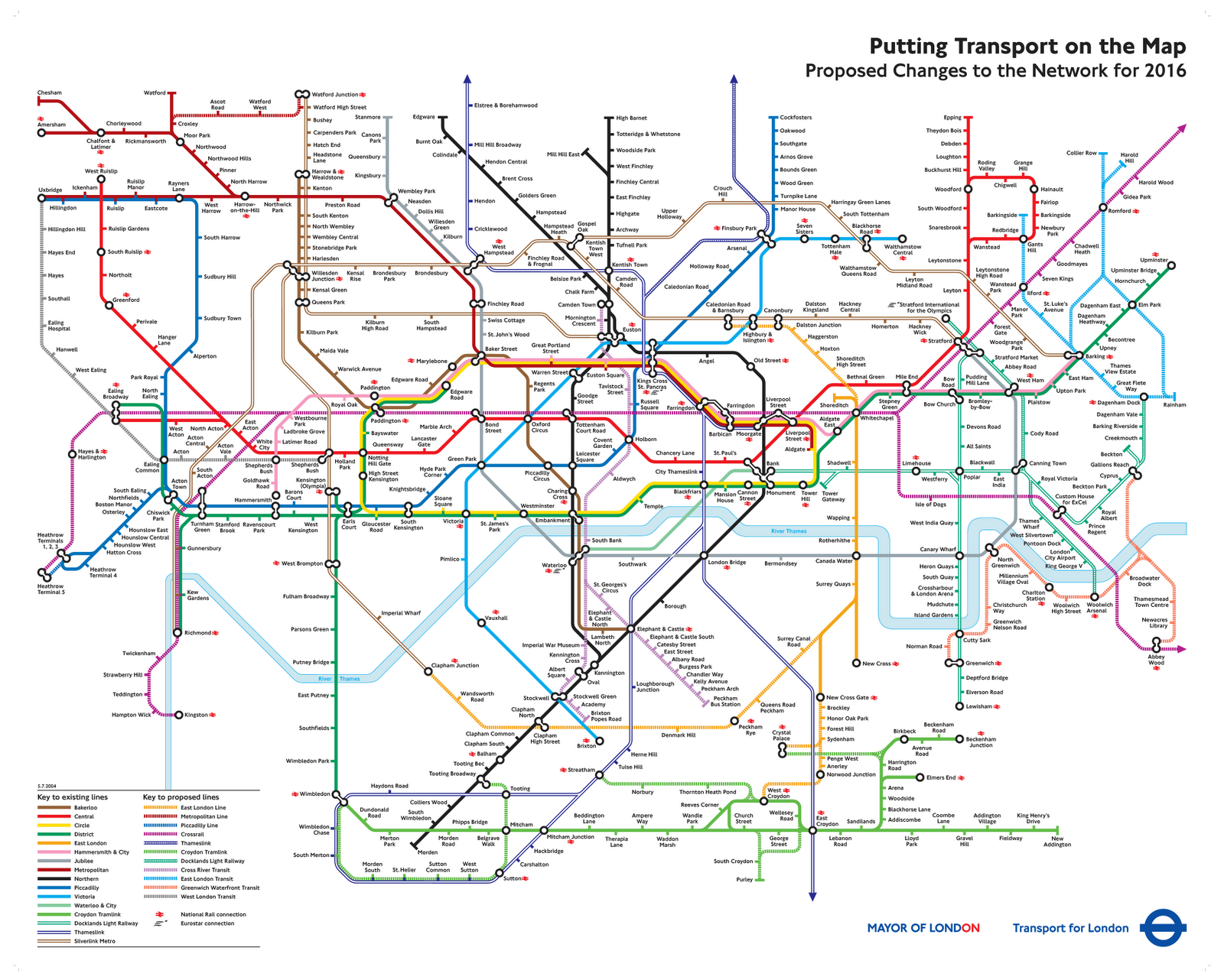
With the right PODs up to the present day, what-if the London Underground (plus Overground, Crossrail) were expanded in the following manner without a restrictive Metropolitan Green Belt and alternate completed London Ringways network (along with potential boring out of smaller deep-level tube lines)?
(Wish there was a way to create an ATL Underground London Map..)
Existing Lines:
Alternate Lines:
(Wish there was a way to create an ATL Underground London Map..)
Existing Lines:
- Central Line – Extends to Uxbridge via West Ruislip branch with stops at Harefield Road and Denham, while terminating at Ongar (with North Weald Airport becoming Epping International Airport and taking over from Stanstead). Includes stations at Park Royal, Shoreditch High-street with an extension from Ealing Broadway to South Ealing as well as from Grange Hill to Ongar via Debden plus a new station north of Chigwell between Grange Hill and Debden. With part of the Woodford to Hainault branch (up to Grange Hill) being transferred to the Victoria line.
- District Line - The final stops on the Main Branch of the District Line are Richmond and Chafford Hundred (latter from Upminster via Ockendon). The former Wimbledon to Edgeware Road branch meanwhile was split off to form the Wimbleware Line, while the ATL expanded Waterloo & City Line took over from the former Ealing Broadway branch up to Chiswick Park along with Kensington Olympia station.
- Northern Line – The alternate Edgware branch of the Northern Line, which kept the name after being extended to Watford Junction (via Bushey) and now goes from Watford Junction to Earl’s Court with notable new stops being at Watford Junction, Bushey, Bushey Heath, Elstree, Brockley Hill, Nine Elms, Battersea, Clapham Junction, Imperial Wharf, Chelsea / King’s Road and Earl’s Court.
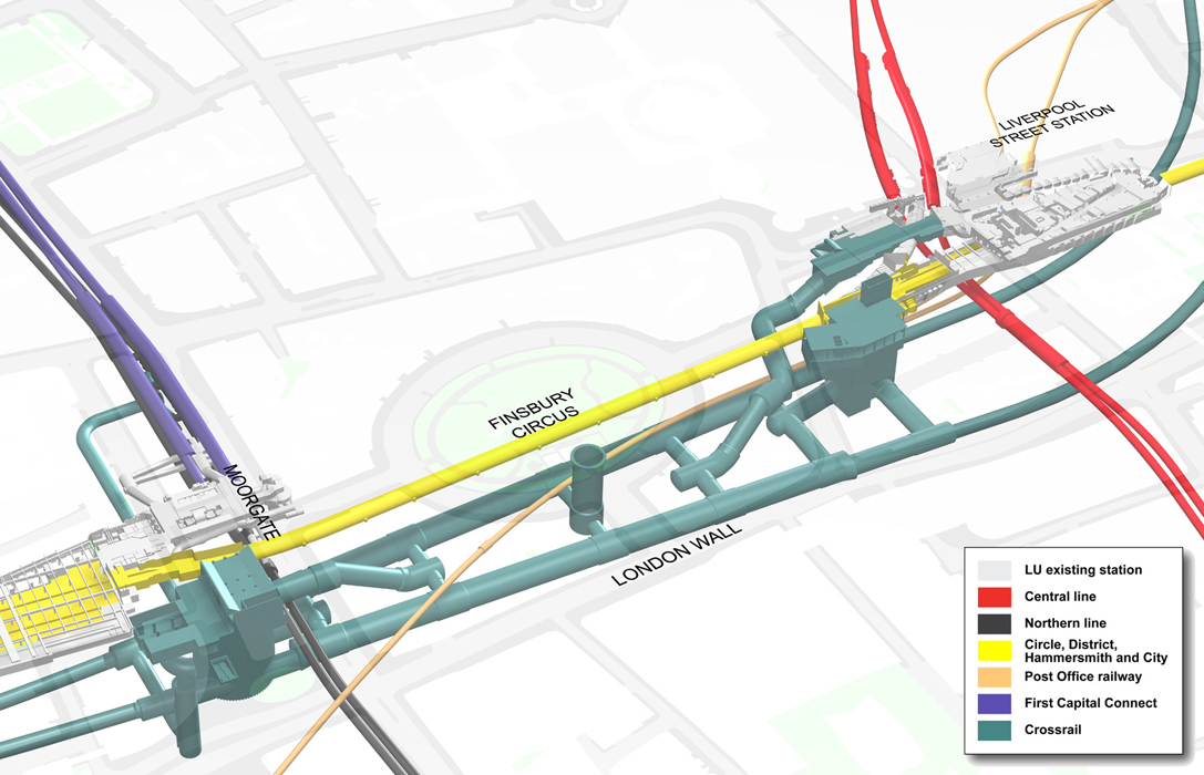
- Metropolitan Line – Extends to Watford Junction via Croxley Rail Link as well as to Canary Wharf from Aldgate, Tobacco Dock and Limehouse (latter inspired by decade old cancelled Metronet proposal for Aldgate-Canary Wharf Tube Link).
- Victoria Line – A southern loop exists from Brixton, calling at Herne Hill, West Norwood, Streatham Common and Streatham Hill. While terminating at Grange Hill from Walthamstow Central via Wood Street, Woodford, Roding Valley and Chigwell.
- Hammersmith and City Line – terminates at Woodford from East Ham (instead of Barking as in OTL) via Ilford, Gants Hill and Clayhall.
- Waterloo and City Line – extends to Ealing Broadway from Waterloo via Ealing Common, Acton Town, Chiswick Park, Emlyn Road, Hammersmith (Circle / Hammersmith & City), Kensington Olympia, High Street Kensington, Royal Albert Hall, Knightsbridge, Victoria and Millbank (vicinity of Horseferry Road) as well as to Hadley Wood from Bank via Moorgate, Old Street, Essex Road, Highbury & Islington, Drayton Park, Finsbury Park, Stroud Green, Crouch End, Highgate, Cranley Gardens, Muswell Hill, Alexandra Place, New Southgate, Oakleight Park and New Barnet (similar to the Northern City Line from Moorgate to Alexandra Place).
- Bakerloo Line – extension exists from Elephant & Castle to Hayes via Lewisham, stopping at Burgess Park, Old Kent Road, New Cross, Lewisham, Ladywell, Catford Bridge, Lower Sydenham, New Beckenham, Clock House, Elmers End and West Wickham. With another extension from Elephant & Castle to Beckenham Junction via Walworth, Camberwell, Herne Hill, Tulse Hill, West Norwood, Gipsy Hill, Crystal Palace and Birkbeck.
- Jubilee Line – Extends to Aldenham via Stanmore (the former was redeveloped from the former Site of Aldenham Bus Works into a New Town) and includes interchange at West Hampstead station combining the 3 West Hampstead stations into one complex.
- Docklands Light Railway / DLR – Southern branch terminates at Forest Hill via Catford or Bromley North via Grove Park while the Eastern branch terminates at Dagenham Dock. Along with a connection between Limehouse and Devons road stations that travels alongside Limehouse Cut with stops at Burdett Road that is later expanded to another branch terminating at Lothbury via London Liverpool Street station and Stratford International with a stop at Vallance Road (near Selby Street) before connecting at Limehouse
- Overground Line – As OTL (plus proposed extensions including stations at Leytonstone, Junction Road, Barking Riverside, Rainham, Purfleet on the Golders Green (via Gospel Oak) to Chafford Hundred Lakeside branch as well as at Hampstead on the North London branch) along with an extension of the Lea Valley branch from Cheshunt to Epping International Airport (aka North Weald Airport)
- Crossrail 1 / Elizabeth Line – As OTL (plus proposed extensions including stations at London City Airport aka Silvertown, Ladbroke Grove / Portobello Central and Old Oak Common as well as extension from Abbey Wood to Gravesend) along with a station at Mile End Park.
- Piccadilly Line - Terminates at Slough from Heathrow Terminal 5 via Sunnymeads and Datchet
- Circle Line - Unchanged
Alternate Lines:
- Wimbleware Line – Formerly the Wimbledon to Edgeware Road branch of the District Line, it was later extended from Edgeware Road to Newbury Park via Marble Arch, Green Park, Charing Cross, Aldwych-Strand, Ludgate Circus / Thameslink, Fenchurch Street, Wapping, Millwall, North Greenwich, London City Airport, Beckton, Barking and Ilford.
- Barden Line – The name of the alternate High Barnet to Morden via Bank Branch of the alternate Northern Line that was split off to form a separate line (and extended to Elstree & Borehamwood).
- Mayfair Line – Hammersmith to Enfield Town via Lillie Road, Fulham Broadway, Imperial Wharf, Chelsea Embankment, King’s Road, Belgravia, Mayfair, Soho, Charing Cross, Aldwych-Strand, Ludgate Circus / City Thameslink, Cannon Street, Fenchurch Street, Aldgate, Aldgate East, Brick Lane, Shoreditch High Street, Haggerston, Dalston Kingsland, Stoke Newington, Stamford Hill, Seven Sisters, Northumberland Park, Angel Road, Edmonton Green and Bush Hill Park or to Loughton from Edmonton Green via Highams Park and Chingford.
Last edited:

")