Where the Sun never sets - A Spanish Oceania TL

The expedition of Juan Fernández
The life of Juan Fernández was an exciting one. Born in Cartagena, Murcia between 1528 and 1530. Being born in the major port of Castile in the Mediterranean he promptly grew an interest in sailing. He was promoted to captain and major pilot sometime in the 1550's and in the 1560's he was sent to the Vicerotalty of Peru, where he was destined to the Captaincy General of Chile to serve as a member of the navy along with Juan Jufré and Hernando de Lamero. Fernández's first success was the discovery of a route that avoided the Humboldt Current in 1574, shortening the time needed to sail from Lima to Valparaíso from six months to thirty days, being unofficially nicknamed as "The wizard of the Pacific" after this. By that time his collegue Juan Jufré had conquered the region of Cuyo (westernmost central Argentina), assuring it for the Captaincy General of Chile under the rule of Melchor Bravo de Saravia.

However his discoveries would not stop there. While in a talk with Jufré, he proposed him to send an expedition to some islands that he discovered during his trip from Lima to Valparaíso (named Juan Fernández islands after him), however Fernández was far more interested in the theoretical Terra Australis Incognita, a landmass that supposedly existed to counterbalance the unequal distribution of the continents in both hemispheres. Jufré supported him and talked with the Captain General of Chile, which agreed to support him. However the Viceroy of Peru, Francisco Álvarez de Toledo refused to find an expedition there and only allowed the expedition to reach the Juan Fernández Islands. Fernández and Saravia secretely kept funding an expedition to sail further beyond the islands without the consent of the Viceroy.

Juan_Jufr%C3%A9.jpg

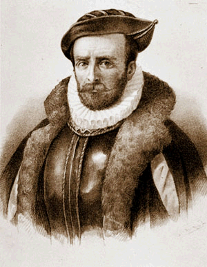
Portait of Juan Jufré, sadly there is none of Juan Fernández

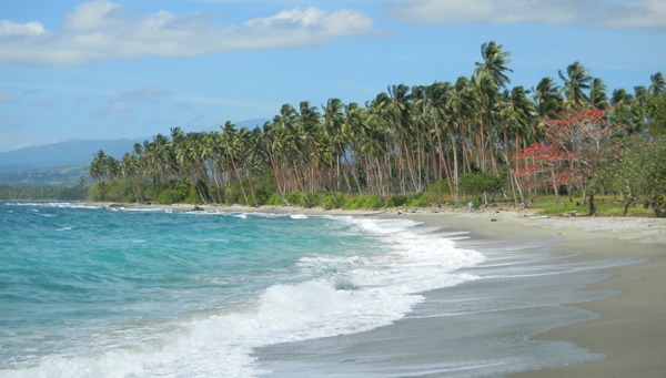
The expedition set sail around late February 1576 and by April, after a single month of travel using southern currents, Juan Fernández reached an island of considerable proportions, that he described as "mountainous, fertile, with strong-flowing rivers, inhabited by white peoples, and with all the fruits necessary to live". His interest grew and decided to try to surround it and check if it was truly the Southern Continent or just an island slightly bigger than those he sighted in Polynesia. He surrounded the entire North Island of New Zealand and while doing so he contacted the native maoris (or Maoríes in Spanish) and traded some goods with them, proving that natives were more advanced than those sighted in other islands or even in some areas America proper. The island he found turned out to be huge, in fact, bigger than the whole of Polynesia put together, and he sighted another island which seemed as big as the North Island right south of it. The natives called the island Aotearoa, which the Spanish deformed into Ateroa, and claimed it for the Spanish crown.

Fernández set sail back to Chile in August 1576 with a reasonably well-made map of the island and how to reach it. When he came back he met with the new governor, Rodrigo de Quiroga and Jufré, with the latter initially refusing to publish the discovery out of fear for reprisals coming from Peru as the expedition was not allowed by the Viceroy. Fernández showed him some of the items he took from the island. He accepted to publish it, but not before the Viceroy of Peru was quietly informed of the discovery. Fernández announced the discovery and the viceroy ordered him to go to Lima for an audience with him. In the talks, the viceroy stated no interest in the island, even with the gifts Fernández brought to him. However during his time in Lima he gained the confidence of some nobles, including that of Martín Enríquez de Almanza, which was promoted to Viceroy after de Toledo's death in 1581.

De Almanza agreed to finance an expedition and to fund a colony in the island while Juan Jufré, who had died in 1578 in Santiago expressed many times his intentions to support Fernández, and thus he reserved a part of his fortune to lend it to him should a second expedition happen. Fernández agreed to incorporate whatever he discovered to the Viceroyalty of Peru, but due to the alleged sheer distance he would be granted the tittle of Captain General and ownerships of the territory subject to the Viceroy and the King. The expedition set sail sometime around March and April 1582, and it reached the island in July. Fernández and his expedition sailed northwards until they found a bay [1] which could be suitable for a colony. He landed there with 50 colonists and 120 indians and named the colony as Medina de Ateroa [2], after Jufré's home town, Medina de Rioseco.

The colony thrived as the climate allowed for crops to grow normally and the native maoris were initially receptive to trade, even if relations deteriorated as time passed. In November, Fernández sent a ship back to Lima stating that the colony had been successfully founded and the location could be suitable for a permanent presence. The Viceroy of Peru died in 1583 before he had news of the expedition and was succeded temporarily by Cristóbal Ramírez de Cartagena, a member of the Audiencia which proved very supportive of Fernández's expedition. He was quickly replaced by a new Viceroy, Fernando Torres de Portugal y Mesía, another of Fernández's friends in Lima which sent an expedition in 1586 to stablish permanent contact with Fernández's colony, which had reached a total population of 150 people (initial deaths had stopped and it had started to grow again sometime around 1585). The expedition also brought needed materials and 30 furhter Indians to assist in the expansion of the colony.

The Spanish had effectively assured a grip on a new territory, the real magnitude of which they only started to imagine.

From now on the TL will be more general, as the colonisation progress is rather slow and the POD doesn't really affect much of the world until some decades to a century pass. Next update will focus in other Spanish expeditions in Oceania.

[1] OTL Plenty Bay
[2] OTL Tauranga
 
Explorando la Mar Océana
This post is mainly focused on Spanish voyages across the Pacific and the cimentations of the Viceroyalty of Oceania.

The expedition of Álvaro de Mendaña de Neira and Isabel Barreto

On April 9th 1595 they set sail from the port of El Callao, including Pedro Fernández de Queirós (which will be an important person later on). On July 21st they reached the Marquesas Islands. Relations were cordial, but deteriorated rather quickly and Queirós estimated that by the time the expedition left, 200 Marquesans had died. When they sighted land again on September 8th 1595 they landed in the island of Santa Cruz [1], concretely on Graciosa Bay. However the settlement deteriorated rather quickly with a military commander being executed and the natives growing more hostile. On October 30th, a rather desperate Neira set sail personally to Ateroa while leaving the colony in the hands of his wife (and also an admiral) Isabel Barreto. When he reached Medina de Ateroa on November 13th, Juan Fernández agreed to assist him and lent him some supplies to support his colony. When Neira returned on November 19th, fifty-two members of the expedition had died due to a mix of malaria and lack of food. When the natives grew tired of the Spanish and tried to attack, they were crushed and the Spanish retaliated by massacring half of the island's population while turning the rest into slaves. During the next months the colony stagnated and another thirty people died. Around January, Neira left to Manila in order to get more supplies from the Philippines. He reached Manila in March 3rd 1596 and came back with supplies in April. When he arrived, there were only 68 survivors and his own wife was sick. With the supplies and native "assistance" they managed to grow some crops and repair their ships.

Alvaro_de_Menda%C3%B1a_de_Neyra.png

Portait of Álvaro de Mendaña de Neira (or Neyra)

Juan Fernández died on July 1596 and his successor Manuel Ortiz sent two ships to check what happened to Neira's colony. The ships got lost but eventually found the island in March 1597 after three months. In the way, the ships discovered a rather large, long island which they dubbed Cana, as the natives called it [2]. With help of the expedition from Ateroa, Neira managed to stablish a permanent outpost in the island, serving as a nexus between Ateroa and the Philippines.

The voyages of Pedro Fernández de Queirós and Luis Váez de Torres

On December 21st 1605 an expedition commanded by Pedro Fernández de Queirós (which returned to Lima in 1599) left from the port of El Callao commanding an expedition to finally settle the issue over the existance of Terra Australis Incognita. The expedition arrived to the colony in Santa Cruz on May 1606. The expedition decided to split then. Queirós decided to wait in the island and move south, while his second-in-command, Luis Váez de Torres insisted on sailign due west as these seas had never been explored while the southern ones were more or less cartographed during the Neira expedition. Torres insisted that the existance of Ateroa was a proof of an ever bigger territory west of it as the islands seemed to grow larger the more you sail to the west. After an argument, Torres embarked his ship, the San Pedro and tried to sail west while actually going southwest. That inconscius move to the south likely saved his ship from crashing somwhere in the Great Barrier Reef.

Torres-map.jpg

An approximation of Torres' route

On August 1606 he landed on an island which he called "Isla de San Buenaventura" [3] and after sailing a bit to the North he discovered that the island was part of a much greater one. Convinced he had finally found Terra Australis he dubbed the island "Australia". He mapped all of Queensland's Pacific coast and reached the tip of Cape York naming the peninsula as "Tierra de Torres". While crossing the Torres Strait (OTL name) he had an encounter with some natives in the islands of it. He was surprised when the natives almost inmediately threw a deluge of frankly unaccurate arrows at them. He defined the islands as savages and the tittle has survived until the modern time as the Savage Islands (Islas de los Salvajes). Torres then sailed to Manila, arriving around January 1607 while in the way cartographing New Guinea.

Meanwhile, Queirós sailed south and further mapped the Vanuatu archipelago and OTL New Caledonia before going south to Ateroa. By that time, the generic name for OTL New Zealand changed from Ateroa to "Las Fernandinas" in honour of Juan Fernández, while Ateroa remained as the name of North Island. Queirós then decided to create a second settlement in Ateroa, Santa Marta [4].

After that, Queirós sailed around the North Island and sailed due South from the westernmost part of the North Island, arriving at a beach close to Okarito. The land he sighted was one of forests and mountains, reminiscent of those of northern Spain. He named the land "Nueva Asturias" and what IOTL became the Southern Alps received the name of "Picos de Europa" (Peaks of Europe), after a mountain range in Asturias that was the first sight of Europe for whalers coming from the Bay of Biscay. By then it was clear that the Fernandines were not part of Terra Australis and that Torres' discovery had a greater chance of being it.

Meanwhile, in a Dutch ship...

The Dutch explorer Willem Janszoon sailed from Banten to explore the western coast of New Guinea and crossed the limits of the Arafura Sea into the Gulf of Carpentaria, making landfall in the mouth of the Los Arbustos river [5]. He named the river R. met het Bosch which the Spanish later translated into it's current name. After that he decided to sail back to Ambon.

640px-Karte_Expedition_Willem_Jansz_1605-1606.png

Willem Janszoon's expedition resulted in him being the first man to land in Australia

By the 1620's, the Spanish were in firm posession of Melanesia, having completely cartographed the Bismarck Archipelago (Islas de San Jaime), the rest of the Solomon Islands, all of New Guinea and the whole of New Zealand. Most of southern Polynesia was also sighted by the Spanish and some contacts had been stablished with the locals, usually with no good result.

pacifico 1620.png

1620: From darker to lighter: Territories settled by the Spanish, territories explored and territories claimed in virtue of the Treaty of Tordesilhas

[1] OTL Nande Island, Vanuatu
[2] The Kanaky, natives of New Caledonia. The Spanish forgot the last syllable
[3] OTL Fraser Island, Queensland
[4] OTL Whangarei, New Zealand
[5] Pennefather River, Queensland
 

Gian

Banned
Well, the Spanish also had an outpost in Formosa until the Dutch expelled them in 1642. Any chance we'll see them survive and ultimately thrive (Would love to see the island not totally sinicized like IOTL, which the Dutch and later Koxinga and the Qing facilitated)
 
I think a POD being before 1570 will butterfly the complete conquest of Luzon because the current politics at that time allowed for it to happen...but you can do the TL in your way...just making my comment...

It is Lakandula's shenanigans that allowed for that to happen.
 
I think a POD being before 1570 will butterfly the complete conquest of Luzon because the current politics at that time allowed for it to happen...but you can do the TL in your way...just making my comment...
But the PoD is in 1576. Juan Fernández was an IRL explorer that according to some discovered New Zealand by accident. Doubt the PoD butterflies away into a non-Spanish Luzon but I'd have to check that further.
 
But the PoD is in 1576. Juan Fernández was an IRL explorer that according to some discovered New Zealand by accident. Doubt the PoD butterflies away into a non-Spanish Luzon but I'd have to check that further.

Thanks for clarifying that the POD is 1576 not Pre-1570 since at that point Luzon is under the Spanish.
 
Oceania (1620-1700)
The Fernandines (1620-1700)
As was mentioned in the first chapter, relations with the Maoris were initially cordial, but as the Spanish colonies expanded they violated the territory of the Maoris. The Maoris initially backed down as the Spanish took posession of the whole northern coast of Ateroa by the 1620's, having stablished other 3 colonies: Villaluz [1], Santa Lucía [2] and Almagro [3] (this one will be important later on). Meanwhile, the original colony of Medina had expanded stablishing a series of outposts to the South, reaching Rotorua and founding a settlement. The explorer Martín de la Hoz crossed the entire Ateroa island by land, going south from Medina to Rotorua and then reaching Lake Taupo. He surrounded the lake and continued south until Lake Rota (A misspell of the native Rotoaira) and continuing south until reaching Mount Ruapehu, which de la Hoz nicknamed as "Pico de la Niebla" (Fog Peak) and stablished a settlement on it's southern base, also called Niebla. Then he continued down the Los Cisnes River [4] and after reaching the sea he built a ship and sailed north to Almagro. During his journey he met several times with hostile natives which even attacked his encampment at Lake Taupo in which de la Hoz was saved by his second-in-command, Juan Lugre.

De la Hoz expedition.png

De la Hoz's expedition marked in yellow. Red dots mark settlements at the time of the expedition, and green ones major settlemens by 1700.

This incident triggered a series of reactions in the north of Ateroa which de la Hoz ignored as he traveled southwards. A Maori caudillo named Tokoroa unified the tribes between lakes Rotorua and Taupo and decided to expel the Spanish from the surroundings. On April 1643 he laid siege to the town of Rotorua. The siege lasted for seventeen days until the Maoris breached the wood walls and executed all the remaining population, with many fleeing to Medina. The governor at the time, José Vega, formed and trained a militia force of 500 men from Medina and Santa Marta. He sent a letter to the viceroy of Peru asking for guns and soldiers, but they would take many months. Vega was forced to start a local arms industry and to build walls around the towns. Tokoroa attacked Medina itself on July, but the walls of the town held the attacks and the Spanish placed their best gunners at the top of them, where the Maoris couldn't attack the Spaniards as they had no bows or any kind of projectile besides throwing stones. The Maoris took some guns from the Rotorua settlement, but failed to use them properly. The siege stalled for two months until reinforcements from the eastern settlements arrived and flanked Tokoroa's army, trapping it between the eastern forces and Medina. Tokoroa insisted on not surrendering and after dancing a Haka (Jaca, in Spanish) he launched an all-out attack against the Spanish, resulting in an horrific battle which took a total of 960 maoris and 78 spaniards including Tokoroa which was shot in a lung and then executed by beheading. His forces dispersed after this, but the Spanish retaliated and forced most tribes out of Tokoroa's former territory, leaving it empty for Spanish colonisation. The whole northern part of Ateroa will be completely settled by 1700.

first maori war infobox.png

In that 60 years time frame, the southern coast of Ateroa had been settled being the two biggest settlements Cienríos [5] and San Juan [6], while the southern island of Nueva Asturias received settlers from Europe proper and Peru. The Spanish found difficulties settling the northern part of the island, but when they found the eastern part was a fertile flatland they flooded the territory, quickly overwhelming the natives, stablishing the town of Acantilado [7] which grew to 1200 inhabitants by 1700.

The Exploration of Australia

When Váez de Torres first found Australia, he found nothing of interest, only a semi-arid landscape, with some occasional dots of jungle. The natives themselves were really unadvanced with only those of the Salvajes Islands knowing how to use a bow. Later passerbys, such as Martínez Rubio (1657) found nothing of value in the North. In a second expedition, this time starting from Medina de Ateroa instead of Santa Cruz. He reached a southern part of Australia, cooler, but more forested. He landed in the Medialuna Bay [8] and created a settlement, the first permanent settlement in Australia called San Jaime. He continued to sail southwards until OTL Cape Howe, discovering the landscape and conditions were very similar to those of The Fernandines, then sailing back to Ateroa, reaching Almagro on 1670. His tale of a second Ateroa to the west attracted many which felt the island was getting too small for them and in 1672 San Jaime received a further 120 colonists from Ateroa. Rubio received the ownership of those lands from the Viceroy of Perú. Australia lacked native crops nor big animals for the settlements to rely on, so the first colonists released sheeps, pigs and other farm animals in the surroundings of the colonies, hoping that they expand. And hell they did, but that's out of the scope of this chapter.

However, yet again, this second wave of exploration was beaten by the Dutch. Dirk Hartog made landfall in Shark Bay in 25 October 1616. He spent three days cartographing the islands around, which he dubbed "Eendrachstsland" and then he left as he found nothing of interest, not even people. He left a plate that was later discovered by Willem de Vlamingh in 1697. Later on, Abel Tasman discovered the island of Tasmania in November 1642 and the continued eastwards following the Roaring Forties until he made landfall in Nueva Asturias on December 13th. When he continued to sail north, he encountered the Spanish in OTL Cook Strait (Estrecho de la Hoz). He feared being attacked and tried to scape, but his ship was captured. He was shocked to find the Spanish already settled these lands. He managed to convince the Spaniards his voyage was one of exploration and not one of piracy and he was released on February 12th 1643.

Tasmanroutes.PNG

Abel Tasman's expeditions

When Tasman came back to the Netherlands, he insisted on the urgency of claiming the lands he discovered for the Netherlands before the Spanish did the same. At the time the Netherlands were occupied fighting a colonial war with the Portuguese, but Tasman would find his idea being accepted posthumously, when the United Provinces sent an expedition to settle Tasmania in 1674. The Dutch stablished a settlement without opposition a year later. Later on, the aforementioned Willem de Vlemingh found another settlement called Nieu Den Haag [9] before sailing north and finding Hartog's plate, replacing it with one of his own. The Dutch kept using the name of "New Holland" for their territories down under.

Colonisation of Melanesia and Micronesia

In the last post, we described how the Spanish funded a settlement called Santa Cruz in the Vanuatu Islands. That settlement was not the first one attempted, as the Spanish tried to settle the island of Santa Isabel prior to the PoD, but the settlement failed as the natives could barely feed themselves, much less the Spanish who ate most of the local pigs and food before frictions forced them to leave the island. When the settlement of Santa Cruz was stabilised, the Spanish decided to try again with the Solomon Islands. An expedition by Juan Díez landed on the Guadalcanal island, this time bringing in seeds and food to stablish a long-lasting colony as a bridge between Santa Cruz and Manila. Tha natives initially welcomed the Spanish as did those in Santa Isabel island, but as the Spanish brought food tensions did not rise to a boiling point and the colony thrived in peaceful cooperation, unlike those of Santa Isabel or Santa Cruz.

BonegiBeach.jpg

Playa de Bonegui, Guadalcanal

Spanish ships from the Philippines had also laid claim to a series of island which they called the Marianas and the Carolines. IOTL these islands reamined unsettled to the point by the time of the Spanish-American War, only Palau and Guam had a proper Spanish presence. The history of the colonisation of the islands remains still unknown as most documents were lost, but it's likely that by 1670 the Spanish had settled the islands of Guam, Saipan and Yap. All the islands would gradually be colonised between that date and the 1860's, serving as guano mines and later as tropical resorts.

Formosa

On 1624 a Dutch expedition reached southern Formosa (Taiwan), stablishing their main base at Fort Zeelandia (Anping). The Dutch had a though time stablishing control of the southern part of the island during the first two years. In 1626 a Spanish expedition coming from the east landed in Cape Santiago, but as the area was not suitable for defence the Spanish continued until they reached Keelung, and stablished a permanent fort named Santísima Trinidad. The Spanish then stablished a second fort to the west named Santo Domingo. The Spanish and Dutch co-existed until 1641 when a Dutch fleet attacked Santísima Trinidad and failing to take the city. The current governor sent a message to the governor of the Philippines, Sebastián Hurtado de Corcuera initially refused to send a fleet, but he also received news of alleged Dutch presence close to Australia (prior to Tasman's expedition some Dutch ships passed by the Torres Strait before being forced to go back). An emissary from New Spain urged the governor to assemble a force to protect Formosa and expel the Dutch after their daring attack. The Dutch were preparing forces to attack Santísima Trinidad again, when on July 1645 a Spanish Fleet appaeared in front of Fort Zeelandia and bombed the Dutch ships, impeding them to leave the harbour. Then the Spanish "Tercio de Marina" landed close to the fort while the navy bombarded it. After eight days of combat, Fort Zeelandia surrendered and the other Dutch fort, Fort Provintia did so after ten days. The Dutch had been ejected from Formosa.

640px-Atlas_Blaeu-Van_der_Hem_-_Taioan.jpg

Fort Zeelandia (Fuerte Zelandia)

The Spanish soon discovered that Formosa was valuable to stablish diplomatic relations and trade with the Chinese Ming dynasty, that at the time was suffering from raids coming from the Manchu Qing Dynasty. During the next years the Qing pushed hard, breaching through the Yellow and Blue Rivers and securing the provinces of Zhejiang and Fujian. The Spanish sent am ambassador to the Qing monarch, asking him for trade permissions and in support the Spanish would help him defeat the remnants of the Ming. Emperor Fulin accepted, but the only thing the Spanish did was taking the Penghu (Pescadores) Islands and repelling a Ming attempt to retake them in 1647. The Qing completed their conquest of China while Taiwan was firmly under Spanish hands. The last indigenous state, the Kingdom of Middag was conquered in 1683. The Spanish would take some decades to assert complete control over the mountains of the island.

upload_2019-1-23_14-54-52.png

The Pacific Ocean as of 1700. Orange areas show Dutch settlements.
[1] OTL Kutarere
[2] In the mouth of the Motu River, no town here IOTL
[3] 8 km to the Southeast of Auckland
[4] Whanganui River
[5] West of Pungarehu
[6] OTL Lower Hutt
[7] OTL Christchurch
[8] Jervis Bay
[9] OTL Bunbury, Western Australia
 
Glossary
I'll update this entry after each chapter to keep this useful.

The Fernandines (New Zealand)
  • Ateroa = North Island
  • Nueva Asturias = South Island
  • Medina de Ateroa = Tauranga
  • Estrecho de la Hoz = Cook Strait
  • Picos de Europa = Southern Alps
  • Villaluz = Kutarere
  • Santa Lucía = Ficticious town in the mouth of the Motu River
  • Almagro = Auckland (roughly)
  • Lake Rota = Lake Rotoaira
  • Pico de la Niebla = Mount Ruapehu
  • Río de los Cisnes = Whanganui River
  • Cienríos = Pungarehu (roughly)
  • San Juan = Lower Hutt
  • Acantilado = Christchurch
Other Islands
  • Santa Cruz Islands = Vanuatu
  • Isla de Cana = New Caledonia
  • Islas de San Jaime = Bismark Archipelago
  • San Pedro = Bora Bora
  • Isla de Amat = Tahiti
Australia
  • Isla de San Buenaventura = Fraser Island
  • Tierra de Torres = Cape York Peninsula
  • Islas de los Salvajes = Torres Strait Islands
  • Río de los Arbustos = Pennefather River
  • Bahía de Medialuna = Jervis Bay
  • San Jaime = Jarvis Bay Settlement
  • Eendrachstsland = Shark Bay
  • Nieu Den Haag = Bunbury
  • Ensenada = Port Paterson
  • San Bartolomé Bay = Spencer Bay
  • Nueva Andalucía = South Australia (roughly)
  • Aranjuez = Fisherman's Bay, South Australia
  • La Carlina = Roughly Point Turton
  • Nueva Arcos del Mar = Adelaide
  • Puerto Floral = Roughly Etty Bay
  • Río Vega = Moresby River
  • Oropesa = Clairview
  • San Buenaventura = Rainbow Beach
  • Villarga = Toronto, NSW
  • Vireste = Gipsy Point
  • Punta Hueca = Melbourne
  • Willelmsfort = Beaconsfield
Taiwan
  • Zelandia = Anping
  • Santísima Trinidad = Keelung
  • Islas de los Pescadores = Penghu Islands
Others
  • Cangarú = Kangaroo
  • Guomba = Wombat
  • Casuari = Cassowary
 
Last edited:
Oceania (1700-1800)
The Fernandines: 1700-1800

This chapter will mostly go about the society and economics of Oceania, as nothing relevant really happened during the 18th Century. Oceania was distinct to the colonies in America: most American territories were mining or farming territories, with a ruling class composed by Peninsular Spaniards, followed by the American ones, then the mestizos, the indians and the last in the social pyramid were blacks. Oceania was different, as the native population mixed with the Spanish aswell, but given some colonists came directly from Peruvian mestizos or even Indians, a new social class emerged. The white-maori mestizos were above American indians but under indian-white mestizos, while the Maori in general were considered under the American natives but still over the blacks. Maoris overall were not that numerous and had been exterminated in many areas, most notably northern Ateroa, leading to European and Mestizo colonists pouring in. The similarity of Fernandine climate with that of Spain proper attracted many colonists from the mainland and Oceania became the whitest territory outside Spain proper in the empire.

That wave of colonists brought in a large amount of farm animals, most notably sheep and cows. These extended rapidly across Nueva Asturias and the island's forests were cut down to make space for sheepherds. The Merina sheep (which by the time was considered to produce the best wool) adapted very well from the Spanish steppe to New Asturias' grasslands. Sheep and cow population grew exponentially as the islands were large enough to sustain a huge population. In 1700 there were around 500 sheeps and 120 cows in Nueva Asturias. By 1800 there were 200,000 sheeps and 47,000 cows. The Fernandine wool soon entered the global market when the Spanish allowed foreign powers to trade with Oceania using Spain as an intermediary, however prices were pretty high due to transport costs and Fernandine wool would only become the islands' main exportation in the 1910's.

vacas.png

A group of cows in New Asturias. These would be island's economic stronghold for decades.

Back to human populations, these followed their cattle southwards. The main town of Nueva Asturias, Acantilado grew rapidly as the main port of the island, reaching 40,000 inhabitants by 1800. The Spanish settled along the eastern coast of the island as the western part was densely forested and was well inside the roaring forties, which difficulted navigation and settling. The Picos de Europa mountains blocked most of these winds so the eastern part of Nueva Asturias enjoyed a relatively mild climate. Despite Nueva Asturia's population growth surpassing that of Ateroa the northern island remained the most populated one. The main town and capital of Medina de Ateroa thrived as it was the town in which the galleons from Peru arrived, while Almagro served as the main port if you wanted to head for Australia. Almagro was incredibly well located and by 1740 a second harbour was built in the Pacific shore of the city (remember it's in OTL Auckland, at a feasible distance from the Tasman Sea and the Pacific Ocean). Almagro eventually beat Medina's population around the 1790's, but Medina remained the capital of the islands. The overall northern part of Ateroa was settled by a mixeture of Europeans and Americans, while the southern part received more European settlers than American ones. After the First Maori War, the number of maori-spanish mestizos decreased as the natives grew more aggressive to the Spanish, pretty much like the Mapuches of Chile. The society of Oceania grew distinct from that of America as social class distinctions were minimised, and with many settlers coming directly from Spain proper the island's loyalty was unquestioned, and this would prove vital in the next decades.

portait of medina.png

Portait of Medina de Ateroa in 1784. Back then population of the city was around 62,000

Australia: 1700-1800

Australia was also different from the Fernandines. Australian natives were even more scarce and the Spanish initially considered them as inferior to them or the American natives. Relations were initially cordial with the Spanish and natives traded meat with them. An anecdote is still widely remember in Australia: A Spanish colonist walked inland when he sighted a large, human-like animal that which instead of running moved aroung jumping. The Spanish sighted some aboriginals and asked them "¿Qué es eso?" (What's that), to which the natives, who had no idea of Spanish, responded with "Kan garu" (I don't understand you). The Spanish, who completely ignored they didn't understand him, simply understud "Cangarú". And that's how kangaroos got their name. The kangaroos or cangarus are the national symbol of Australia, present in their coat of arms and in the flag. The natives used the kangaroos as their main source of meat and as a sacred animal, the dinning of which was always preceded by a ritual. The Spanish were not so kind and actively hunted the cangarús for their meat, furs and as exportation products themselves. Similar cases happened with other animals such as the Guombas (Wombats) and the Casuaris (Cassowarys), also called Helmet Birds.

cangaru.png

A Cangarú with her breeding.

The farm animals that the Spanish set free across Australia had wreaked havoc by the 1740's, occupying most of the niches held by native animals wherever they reached. Rabbits were specially invasive and their population went from a three couples set free by a poor trader in 1726 to eight million by 1800. Rabbit meat was used as a food source in Spain proper, so the Australians had no reservations in hunting them whenever they did appear. As Spanish colonists penetrated inland, the center of Australia was gradually divided into huge properties which's only value was their huge size. For example, a certain noble, Alejandro de Luna received 600,000 square kilometers of land in the southwest of the Spanish posessions. Being a rich man as he was, he decided that he could settle the coastal areas and founded the settlement of Ensenada [1] in the northernmost part of the San Bartolomé Bay [2]. De Luna offered parts of his huge territory to other nobles if they assisted in the settlement, and soon a sustainable colony was formed in the southeast, dubbed as New Andalusia. The major settlements were stablished along the western shore of the San Bartolomé Bay and further south with the largest settlements being Aranjuez [3], La Carlina [4] and Nueva Arcos del Mar [5]. By 1800 New Andalusia had a total population of 70,000 colonists.

Australia sp map.png

Map of Spanish Australia by 1800. (Whoops! San Bartolomé should be San Buenaventura)

The Spanish expansion did not limit to the Southwest as the Spanish also spreaded through the southeast and the coasts of OTL Queensland and New South Wales. Spanish settlers founded the town of Puerto Floral in the mouth of the Vega river [6]. The colony of Torres was founded and based aroung the town. Other settlemens also appeared sporadically across the eastern coast of Australia, but none of them would become relevant. By 1800 the whole coast of Australia was well charted, but the inland territories weren't. The next century would see many adventurers explore the interior of the continent in search for gold, water and resources. The Natives simply faded into complete irrelevance past 1720 as their numbers dwindled due to disease and that the Spanish enslaved many of them to work at plantations on the coast, however their numbers didn't grow and they were eventually replaced by African slaves and many of the former Aboriginal slaves ended up being forcibly kicked out to the desert.

However, unlike in the Fernandines, Spain wasn't alone in Australia. The Dutch had stablished a solid presence in the westernmost part of Australia during the late years of the 17th century, and also stablished a fort in the island of Tasmania. During the War of the Quadruple Alliance a Spanish expedition from the Fernandines captured the Dutch settlement of Willelmsfort [7] on November 1719, but had to renounce to the conquest in the subsequent Treaty of The Hague. In such treaty Spain renounced all claims to the island of Tasmania. The Dutch in Australia expanded slowly, as a huge part of their territory was just pure desert, with only Tasmania and the southwesternmost part not being openly hostile. The Dutch behaved moreless like the Spanish and the Dutch made some good money in Tasmania by selling Thylacines' fur and displaying them across Europe as a rare animal from the antipodes. The Dutch stablished coastal towns in the southwest, fishing ports in Tasmania and large agrarian properties in the adjacent lands with these serving as foodstock and overall as sheep farms. The Dutch attempt to colonise Australia to serve as a base against the Spanish would fail as the Spanish would only grow more and more powerful.

gwa.png

Scene of a naval battle during the War of the Quadruple Alliance

The explorer viceroy: Manuel de Amat y Junyent

Born close to Barcelona in 1704, Manuel quickly found out he had talents as a military officer, fighting against the French oofensive into Aragon in 1719. Then he joined the Order of Malta and spent four years on the island before going back to Spain and sent to fight in Africa in the Sagunto Dragoon Company. He had a relevant paper during the War of the Polish Succession, taking part in the decisive victory at the Battle of Bitonto and later leading the Siege of Gaeta which allowed Spain to re-conquer Naples for the House of Bourbon. He was promoted to field marshal before being sent to America in 1755 to serve as governor of Chile. During that time he built a series of coastal fortifications and others along the Mapuche border while trying to sign a permanent agreement that would allow Spain to supply the island of Chiloé, only succeeding in obtaining a partial agreement. In 1757 he restored the Royal University of St. Philip and in 1758 he created the first permanent army of Chile, the Queen's Dragoons. Due to his good acting he was promoted to Viceroy of Peru in 1761, where he built more fortifications in case of an attack during the Seven Years' War and created another Dragoon Company.

Amat.png

Portait of Manuel de Amat y Junyent in 1775

However the act that really brings him into this TL were the series of voyages he organised to the Polynesia after hearing of James' Cook Expeditions. In 1772 he organised an expedition to assure the islands Cook discovered for the Spanish Crown. A fleet set sail from Lima in 1772, commanded by Domingo de Bonechea. Amat also organised a similar expedition from the Fernandines to head east and encounter Bonechea's fleet somewhere close to the Society Islands. Bonechea reached the islands after a pair of months and stablished a small settlement. His mission was to convert the natives to christianity, but those were resilient. The expedition from the Fernandines arrived late, when Bonechea was about to leave Tahiti due to disease, he left the islands to the other expedition and ordered the fleet to sail back to El Callao, though he wouldn't live to see Peru again. The Fernandine expedition stablished better relationships with the natives and when a second Peruvian expedition passed by in 1774, the natives agreed to convert and become subjects of the Spanish monarch Charles III, a monarch, who despite being laicist in his politics, accepted the evangelization of the island. As an anecdote, Queirós (check chapter II) visited a close island and left some dogs there, aswell as a wood cross. The 1774 expedition discovered that island in which the natives mostly fed on dogs, descendants of those left there by Queirós. The Spanish completely charted the islands and named them. Amat's decissions to conquer the whole southern Pacific led to the creation of a permanent Pacific Navy and an increase of evangelization both among Polynesians and Natives.

Islas de la sociedad.png

Las Islas de la Sociedad


[1] OTL Port Paterson
[2] OTL Spencer Bay, South Australia
[3] Fisherman's Bay, "
[4] 6 km east of OTL Point Turton
[5] Adelaide
[6] Moresby River, Queensland
[7] OTL Beaconsfield, Tasmania
 
Last edited:
Good update; don't worry about how often you update it. It's quality over quantity (as I've said, a lot of people on this board go to college or university (depending on what country you're in)…)…
 
Top