You are using an out of date browser. It may not display this or other websites correctly.
You should upgrade or use an alternative browser.
You should upgrade or use an alternative browser.
TrucKola's "Dead Nation" Index
- Thread starter BCATR
- Start date
-
- Tags
- index page truckola
Original post on Map Thread XIX page 158
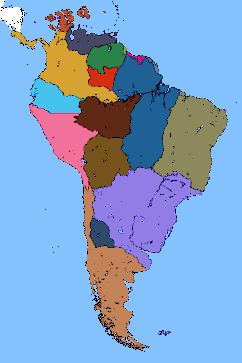
So I wanted to do a revamp of South America in my universe that works towards defying the cartography tropes AH falls to, including a dominant country in the eastern end of the continent. (Não sei do que você está falando.) In my effort, I also wanted to make this map more diverse in terms of history and the choices certain powers took to get the exploitation out of this continent they want.
DISCLAIMER: I will be having some details of these countries that deal with the Atlantic slave trade and racism. I hope my depiction at least paints it in a fair light.
Organizing these nations from their respective colonizing empires:
Great Britain, deciding to come towards the more temperate end of the continent, have found that the River Plate can be the ideal place to have a highly profitable colony similar to the colonies of North America. It has proven to become a highly profitable colony, despite very racist policies that incentivized settlement towards the North to exploit the Southern Amazon and eradicate natives. Today, with 130 million citizens, Plate is the most prestigious country in South America having a GDP of $1 trillion USD.
Spain (more like Castille), heavily invested in the search for El Dorado after coming in contact with the Muisca culture, was planning to search, and even colonize, the Amazon, where even if they don't find El Dorado in the dense jungle, they could exploit it to control a timber supply for building a great navy. The Spanish Empire in South America extended from Colombia to Upper Peru, with small exclaves in the Caribbean. This empire came at a cost, however, as the Spanish had to take the Amazon away from the Portuguese during the Papal Wars. During the Revolutionary years, where Spain was in its own revolution, the Empire fractured and came to divide into (from west to east) Colombia, Ecuador, Peru, Madura (pink island in New Holland), Lingor (between New Holland and Federmannia), Nueva Jaen, Upper Peru, and Amazona. A rare occasion of settlement in the New World happened during the 19th century where Peruvian settlers moved to the modern day San Juan Republic in former Patagonian territory. In 1894, the San Juan Independence Movement came to be when the recent Peruvian immigrants felt their rights were being revoked during the Patagonian government's Provincial Reformation Act which saw the region's political power being waived over to the federal government. The region became a burden to the Patagonian government so they saw a conference to negotiate San Juanian independence. In 1899, the Republic is its own sovereign nation, with good relations with Patagonia and Plate lasting today.
An expedition funded by Salzburg that got the Klien Venedig colony started (now called Federmannia) soon became a subject for the Holy Roman Empire's gains in America. Despite significant funds from some North German states, the massive influx of colonists were only South Germans, including Bavarians, Wurtembergers, and Austrians. The capital city, New Ulm, prides itself as the best city in South America, having the highest quality of life, most access to cheap if not free education, and bolsters an environment that allows small businesses to thrive.
The Crown of Aragon began its ambitions in America after hearing legends of El Dorado circulating from Castillan sources. The Catalan-heavy populations of conquistadors and servants began their expeditions and having motivations to get away from Europe. After El Dorado quests died down, promotions to develop and occupy the lands from the Guyana coast and into the Amazon were convincing thousands of Catalan peasants, merchants, and engineers to go to the colony of Nova Barcelona. Patagonia was colonized but disputed until the Treaty of Madrid in 1557, at the end of the Papal Wars, was ratified where the Pope called for Aragonese legitimacy over Patagonia while the Spanish would have legitimacy over the Amazon and the Portuguese would have no legitimacy over any of America in favor of the Spanish. During the Spanish Revolution and the First French Revolutionary War, Aragon was in a precarious position where they could not maintain control over Nova Barcelona while the threats of Spanish revolutionaries and the French invasion forced Valencia to abandon the colony along with its colonies of Hondures and Cuba. The resulting independence movements had the colonies free from Aragonese rule. In the 20th century, a syndicalist commune rose to power in the Amazonian province of Nova Barcelona and the Nova Barcelonian Civil War had the independence of the Amazon Commune won. Out of the colonies, Patagonia is the most successful being the second most prosperous nation in South America behind Plate, with a GDP of $435 billion USD.
Denmark had turned their ambitions from the North Atlantic to move abroad, trying to copy the Portuguese model of exploration and colonization, almost gaining the same success as the Portuguese did in exploration with many islands in the Indian Ocean being discovered along with the more successful exploitation of Bandiaterra, and Danish Guyana, better known as Lokono today. Lokono is the pride of the Danish crown and despite a rocky history with assimilation of the natives being forced to speak Danish, the country still has good relations with her mother country, today part of the federation of Scandinavia. Established in 1962, Lokono has a fairly healthy economy and quietly resides as a tourist destination.
France barely made any progress outside of Canada, which was taken up by Britain during the Last Continental War, which for the acquisition for Normandy, Brittany, and Bordeaux, the French agreed to cede Canada, allowing British hegemony over North America. However, they would still be able to keep French Guyana, today known as Parikwene, and Atlantique, two islands in the Azores Archipelago now under German sovereignty. Not only was the territory established as a refuge for pirates but almost poetically for the royal family in the country's darkest hours. The French Revolution had Parikwene residing as a refuge once more until in 1773, after five years of asylum in Parikwene, the royal family was assassinated by Revolution sympathizers. For the duration of the French Revolutionary Wars, Britain had a port leased in agreement for protection of the territory as independence movements in South America were heating up the Spanish Empire. Today, Parikwene enjoys a similar economic situation as Lokono and is part of the Guyana Economic Community.
Great Guinea, as named by the European powers, was first contacted by the Portuguese in their expeditions, and seeing this European maritime power that established a flow of information that allowed the Guineans to see the wider world brought many inspiring ideas of establishing their own maritime empire. Going off of the Portuguese discovery of Brazil, the Guineans built a navy and an expeditionary patrol to claim Brazil, now known in the Yoruba exonym, Igipupa, named after the brazilwood trees. The Guineans were able to maintain control over this colony through its exportation of slaves. A highly debated topic between historians was how the Guinean colony was able to be preserved asserted that the Europeans allowed Guinean hegemony over this corner of the continent for being generously supplied slaves, which provided a large amount of wealth which fed back to the colony's security and development. In the dark history of the slave trade, it was calculated that about 70% of colonists in Igipupa were brought across the Atlantic under slavery. Trans-Atlantic slave trade ended between a British-Guinean treaty before a conflict escalated to war in 1815 where slaves would no longer be transported across the Atlantic allegedly to decrease piracy. At the same time, the Guinean Industrial Revolution was coming, as part of the greater Ethiopian Industrial Revolution, as started in the Kingdom of Ethiopia. A British-Guinean Cooperation Treaty was later signed in 1833, where disputes between Plate and Igipupa would cease. This cooperation would also gain Great Guinea some industrial knowledge the British gained and it helped Igipupa develop far faster. Slavery was abolished in the Guinean Empire cordially with the British in 1840 and the slaves in the Empire were admitted as equal citizens. Today, Igipupa is a relatively healthy economy, being the 4th most prosperous nation in the continent, behind Patagonia, at $223 billion USD. However, the nation is far from being anything near being a well-maintained country, as corruption that began in the 1980s during an oil crisis still brews within the country today.
The Dutch have pulled significant gains across the world, copying the Portuguese model as the Danes did, but they moved to pore their resources in building and maintaining New Holland. The area was originally four colonies of Friesland, Haag, Nieuw Brussel, and Rijnland, and each contributed great power to Amsterdam in the sugar trade. Expeditions to the East Indies brought coffee and spices that can be grown in the colonies as well, which allowed the Dutch greater power and didn't need to traverse the world so much to get to their Spice Islands. The Guinean Trans-Atlantic slave trade gave the Dutch low-cost labor that fueled the development of the colonies led to problematic relations between the white settlers and the African New-Hollanders in the nation similar to the American South. This tension has lasted today where underprivileged classes still face prejudice. This dark history of New Holland is held on the shoulders of its citizens today, but many strides have been made after Council voted in bills to give African New-Hollanders rights to be more equal citizens. By 2012, many improvements have been made but according to the University of Raleigh (US) Prejudicial Census, New Holland is still one of the most socially prejudicial countries in the New World, ranking at 2nd behind Hondures (for its own reasons of class, gender, and homosexual prejudice). Despite this grating societal tension, New Holland boasts the 3rd largest economy in South America, being the dominant economy in the Caribbean, as well as being the martial power of the Caribbean alongside the US.
Last edited:
Original post on Map Thread XIX page 160
So, a sequel of the South America revamp of my map is released, freeing the primary map from all the clutter and using the brilliant work by @Rac98 to give the globe its lines (which have helped me adjust some landmasses closer towards the curve of the map). And I'm gonna call my universe "Citizens of a Dead Nation" based on the title of a book I plan on writing taking place in one of these very interesting locations, if not a couple more.

Also, the Oslo Meridian rules.
So, a sequel of the South America revamp of my map is released, freeing the primary map from all the clutter and using the brilliant work by @Rac98 to give the globe its lines (which have helped me adjust some landmasses closer towards the curve of the map). And I'm gonna call my universe "Citizens of a Dead Nation" based on the title of a book I plan on writing taking place in one of these very interesting locations, if not a couple more.
Also, the Oslo Meridian rules.
Last edited:
Original post on Graphic Thread I page 68
Title for a planned book set in my universe. I haven't decided where it should be set, whether it would be Africa, America, or Asia.
(The font is inspired by Dying Light's font)
Title for a planned book set in my universe. I haven't decided where it should be set, whether it would be Africa, America, or Asia.
(The font is inspired by Dying Light's font)
Last edited:
Original post on Map Thread XIX page 172

I swear this will be the last update to my WORLDA map for my universe. The QBAM version is on page 170.
I swear this will be the last update to my WORLDA map for my universe. The QBAM version is on page 170.
Original post on Map Thread XIX page 109

A map made in-universe in my megamap (link in the signature) where a question was asked "what if Mitteleuropa united?" The kind of question RealLifeLore would ask for a 5 minute long video.
A map made in-universe in my megamap (link in the signature) where a question was asked "what if Mitteleuropa united?" The kind of question RealLifeLore would ask for a 5 minute long video.
Original post in Map Thread page XIX 172
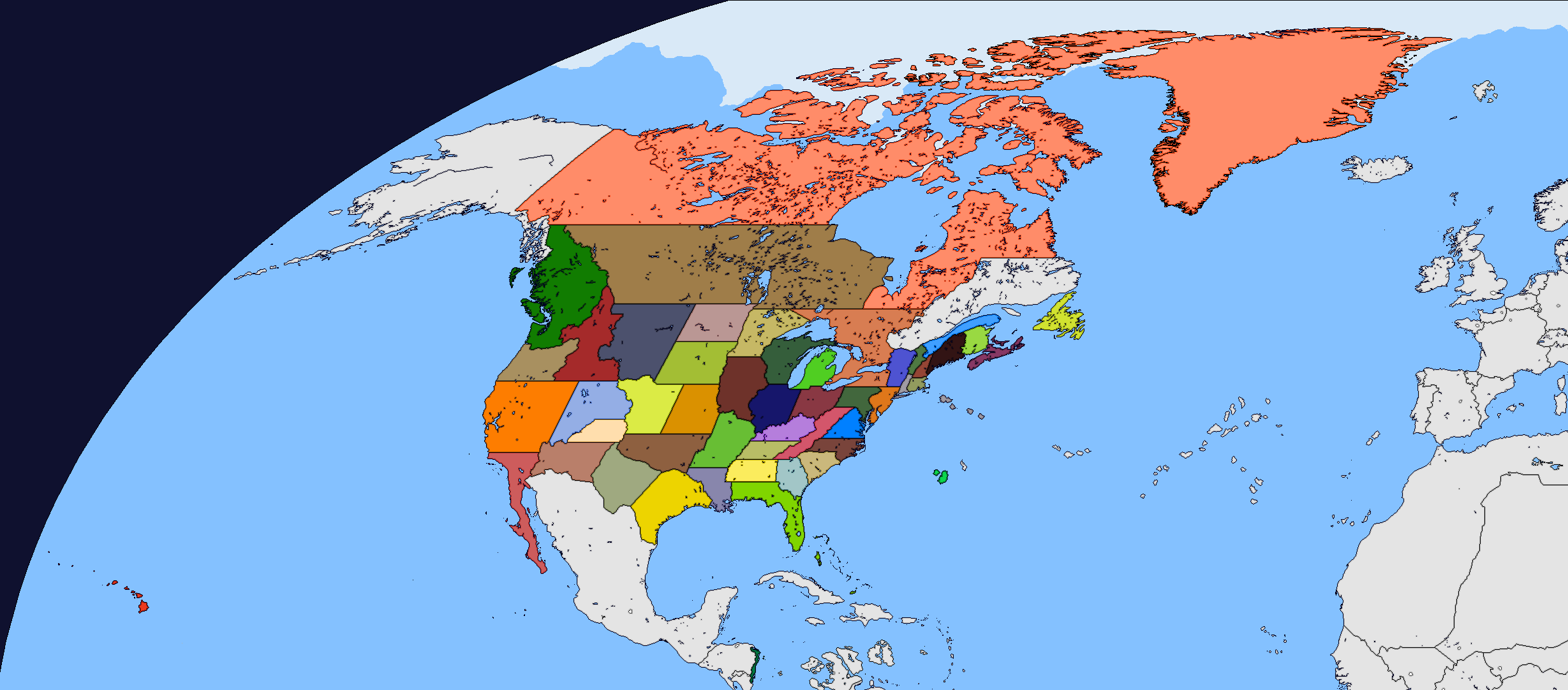
Map for the US. I'll release a key for the states some time soon.
Map for the US. I'll release a key for the states some time soon.
Last edited:
Original post in Map Thread XIX page 185

A map game of Guess Where WW1 Started! The date is 1897, when in May 14, a particular event happened that caused the outbreak of the war.
You will use this map to guess where the outbreak may have started.
The alliances are:
Entente: France, Russia, Serbia, China
The "Cambray" Alliance: UK, Belgium, Mitteleuropa (Germany, Venice, Hungary), Ethiopia
The Ottomans, Italians, Japanese, and Aragonese are wild cards. They are in neither of these alliances but they eventually choose a side based on their situation in their borderlands with these other powers. Cause this war gets big.
The Americans choose to back up the Cambray Alliance and fight the French in 1899.
Original post from Map Thread XIX page 185
So, I've waited long enough to allow people to speculate, and I'm gonna reveal the two inciting incidents that escalate to war.
Due to the dramatic rise of nationalism and nationalist philosophy in the mid 1800s (which contributed to Germany unifying earlier than OTTL), a lot of these proxy states under foreign rule have a lot of sentiments to be very volatile.
An international crisis in the Strait of Hormuz between the French and Ethiopians is one contributing factor. In a peace summit in Rome on May 3rd, 1897, the ambassadors from both these empires asserted that they aren't going to back down from it, since the oil boom has influenced these nations to be so aggressive in the Middle East. The crisis escalated when a standoff between an Ethiopian convoy and French fortified guns at Suez was occuring. The Arabian government was also present at the peace talks, quietly spectating.
The second incident that nullified all peace talks was the Armenian Incident. An Islamized Armenian allegedly part of an Ottoman-funded terror group "The Crusaders" shot the Prince of Armenia, within the Russian sphere of influence. As soon as the Russians caught wind of the attempted assassination during the peace talks, they cried out a conspiracy was being plotted against the Entente.
War began, and the Ottomans joined the Cambray Alliance to compensate for the four front war they are about to defend themselves against.
This is deductive reasoning that takes the cake. Best guess by far.Considering it was stated that “iran is geographically close (but not correct):
Iran generally is not a possibility, as it is shared by two allies and the only other bordering nation is one of the neutrals
Egypt might wanna break free from France, and also borders Ethiopia, so it could be related to that, even if the other neighboring countries are exclusively neutrals
Tibet might want to remove the yoke too but is otherwise bordered by mostly Russia and China (allies) so relatively unlikely
Saudi Arabia could be an area of importance too especially since I don’t see already established SoI, but then again it’s less likely to start a war over not yet existing SoIs or if someone is expanding their SoI in Tibet or there (unless a treaty prohibited that)
which more or less leaves out south india and probably something involving one of the smaller statelets being bullied (eG occupied) by ethiopia or France, which would be a more direct infringement on SoIs, and considering both empires are huge and brought a lot of foreign land directly under their control (see practically unified french india) these small states might actually be protected by some treaty.
my bet would be on India or maybe Saudi-Arabia, both in regards to SoI infringement.
It’s sad that we don’t know the categorical (diplomatic insult, simple conquest, SoI infringement, trade threats, uprising, boi killed etc.) cause of the war since it would make things easier and more creative than wild guessing but yeah
So, I've waited long enough to allow people to speculate, and I'm gonna reveal the two inciting incidents that escalate to war.
Due to the dramatic rise of nationalism and nationalist philosophy in the mid 1800s (which contributed to Germany unifying earlier than OTTL), a lot of these proxy states under foreign rule have a lot of sentiments to be very volatile.
An international crisis in the Strait of Hormuz between the French and Ethiopians is one contributing factor. In a peace summit in Rome on May 3rd, 1897, the ambassadors from both these empires asserted that they aren't going to back down from it, since the oil boom has influenced these nations to be so aggressive in the Middle East. The crisis escalated when a standoff between an Ethiopian convoy and French fortified guns at Suez was occuring. The Arabian government was also present at the peace talks, quietly spectating.
The second incident that nullified all peace talks was the Armenian Incident. An Islamized Armenian allegedly part of an Ottoman-funded terror group "The Crusaders" shot the Prince of Armenia, within the Russian sphere of influence. As soon as the Russians caught wind of the attempted assassination during the peace talks, they cried out a conspiracy was being plotted against the Entente.
War began, and the Ottomans joined the Cambray Alliance to compensate for the four front war they are about to defend themselves against.
why does Burkina Faso have the same borders as OTL?
"Guinea" and "Nigeria" look pretty space-filling. Maybe you should break them up?
"Guinea" and "Nigeria" look pretty space-filling. Maybe you should break them up?
I got a map that uses some of Drex's African borders. One reason why Nigeria looks so but is because it is an Empire, and wasn't a colony of the European powers.why does Burkina Faso have the same borders as OTL?
"Guinea" and "Nigeria" look pretty space-filling. Maybe you should break them up?
Original post in Map Thread XIX page 194

My universe's WW2, with this map depicting the height of the opposition to the Allies, "Narzak" (Народный закон) Russia, Italy (Latin Federation), and the Empire of Japan. The date is July 1951.
The non aggression pact between Rome and Moscow sealed the fate for Europe. Eventually, the German line would implode and Brunswick would be the last line of defense before German surrender. The Russians and Italians have funneled Europe into a polarized political sphere with the Germans, the Iberians, the British, and the Scandinavians in between. One frontline that still remains in Eastern Europe is the ongoing Battle of Konigsberg.
The Islamic Revolution that had been brewing underneath civil conflict for years had erupted and taken the Middle East by storm. At least the Russo-Ethiopian Peace Treaty made in 1948 had given the Ethiopians breathing room for the growing revolution that is kicking them out of Mesopotamia. The Ottoman regime had taken exile in Cyprus while the front is still being fought, hoping to escape the rebels who call for the death of the monarchy.
The Japanese Navy was able to surpass the logistical challenge of invading India with the port in Rangoon. The Ethiopian Raj now in land conflict to kick the Japanese out along with the landlocked British territory. The front in Manchuria has been distracting the Japanese, as this front is the second largest and deadliest place in the world behind Europe. The cracks will begin to show as the Japanese war machine will soon spread itself too thin, with historians citing the invasion of Antipicardie as the turning point that will take this problem magnified.
North Africa fell into disarray as the Aragonese were forced out of Europe and their territory in North Africa down to the Sahel. The German Colonial Army in Africa and the Guinean Army had to take over in Aragon's place as the primary army has been captured in the Battle of Nice and in the Battle of Bordeaux in 1948. The objective being a plan to usurp Italian hegemony over the Mediterranean Sea.
The Americans would eventually get to Europe by December as they secured the captured islands in the Atlantic and aid the British Navy in the English Channel to have supremacy and send troops to Calais and Antwerp. The battle over in the Danish Archipelago may decide if the Russian Baltic Fleet will go into the North Sea to challenge Allied hegemony.
The Russian line in Eastern Europe collapsed as the Battle of Berlin was won by the Germans and soon, the Russians had to relinquish conquered gains as the Eastern Front worsened. The liberation of New Moravia and North Austronesia allowed the Americans to hold a new point where the campaign in East Asia can be won with island hopping. The African Front came to a close and soon, air raids were conducted over Iberia, the Balkans, and Southern Italy. The airbase on Harran that was saved by the Ethiopian Marines in 1950 was the primary point where Italian influence in the Balkans can be ground down. Recapturing Tyrol and Vienna gave a chance to have air superiority in the Alps.
The end of the war, however, was not decided by force by ground troops or by naval steel, but by a few bomber jets and 8 atomic warheads. The first three detonated in the Russian industrial core, and this convinced the Narnaks that the war they waged was compromised when a few planes that are of unprecedented technology, out of range of their own fighters and their anti-aircraft guns, were able to deliver unprecedented firepower to the motherland. A day after the simultaneous strikes happened, Russian generals came to the Allies to negociate surrender. The same happened with Japan with only 1 strike in Shizuoka, Japan. Unfortunately, the Latin Federation did not give up so easily. Belluno, Florence, Bologna, and Naples were bombed in respective order over the course of three weeks before surrender was even mentioned, yet the Italian regime soon saw how destructive the atomic bomb is. The war ended on January 13, 1953.
Original post on Map Thread XIX page 194

A companion to my WW2 post is a The New Order/Kaiserreich-ish world where the Panslavist Narzak Russians rule the world along with the Latin Federation in 1960. To explain why the Italians lost the Balkans is because the non-aggresson pact expired and after the Balkans and most of the east half of Africa was conquered, a new non-aggression pact was signed as the Panslavists found their present situation pleasing enough. The Russians also defeated the Japanese through a land invasion in Korea and the mainland archipelago, and forced the Americans their hand and dominates the Arctic Circle. A negotiation with Ethiopia granted them parts of their mainland territory for the gains they looted in Europe. The Ethiopians would find as much use as they could with it as India imploded and the Pakistani Horde rose up as part of the Islamic Revolution. The Persian Civil War had the surrounding regions take advantage of the power vacuum and even the Russians found an advantage to annex some lands and establish a new satellite state. A new Space Race between the Latin Federation and the Panslavs would occur for global favor.
A companion to my WW2 post is a The New Order/Kaiserreich-ish world where the Panslavist Narzak Russians rule the world along with the Latin Federation in 1960. To explain why the Italians lost the Balkans is because the non-aggresson pact expired and after the Balkans and most of the east half of Africa was conquered, a new non-aggression pact was signed as the Panslavists found their present situation pleasing enough. The Russians also defeated the Japanese through a land invasion in Korea and the mainland archipelago, and forced the Americans their hand and dominates the Arctic Circle. A negotiation with Ethiopia granted them parts of their mainland territory for the gains they looted in Europe. The Ethiopians would find as much use as they could with it as India imploded and the Pakistani Horde rose up as part of the Islamic Revolution. The Persian Civil War had the surrounding regions take advantage of the power vacuum and even the Russians found an advantage to annex some lands and establish a new satellite state. A new Space Race between the Latin Federation and the Panslavs would occur for global favor.

The final rendition of my map before I decided to end this project in December 2019/January 2020. Coming up with a cohesive history became too much of a big thing for me to handle, and it would overcomplicate stories I intend to create that would end up being too divergent from our own history to be understandable. I thank you for your kind comments and admiration for this piece I spent two years eventually coming to this point, but it was too much of a "good thing" to continue.
Share: