How did the world wars go here?
That is a topic that will be covered in the future.
Whoa, that's a huge disparity! I've seen people think an electoral system is out of whack when there's deviations of more than, say, 10-15% between two seats (I seem to recall the relative overrepresentation of Scotland in the British Commons was a major issue pre-devolution). Have any of the provinces tried to fix this on their own by redrawing counties, or are boundaries set by Parliament itself/at the federal level?
Provinces don't have an incentive to fix it. Why would they purposefully lower their own representation in Parliament? If they did anything, it would be making *more* counties, so they'd be even more represented. Instead, it requires Crown approval to modify a Royal Charter to include a new county, or to change county borders, which makes the process extremely difficult to do. The boundaries are set by Elections New England, and the way the electoral law is written, seats are allocated not by province, but by county. So if a county is allocated 2 seats, Elections New England must create two seats that make the most sense, with little care or regard to population size.
I'm curious, in real life there is a large Orthodox Jewish community in South Brooklyn, which tends to vote heavily Republican, so what occurred differently that resulted in the area voting for Labor?
There is a large, overwhelming number of African-Americans and other immigrants from across the Empire that make up a lot of the Brooklyn area's population. While an Orthodox Jewish population does exist in this same general area, they often get easily outvoted in national elections.;
I just finished a biography on John Adams and what is his legacy in the TL? Did he do much in New England history?
John Adams remains a famous statesman, most notably so as Massachusetts Bay's first First Minister, who set out many of the foundational norms that New England follows today.
I’m very interested to find out more about the TTL fate of the Northwest Territories. IOTL the British still had control of much of it at the end of the ARW, including Detroit. They only left (well, after another decade or so of occupation and incursions, anyway) after negotiators conceded it at the Treaty of Paris. They even took parts of it back for a time during the War of 1812, alongside an alliance of native tribes.
I wonder what led the Brits TTL to give up the Northwest Territories—the US election maps already posted imply that the US controls them after the *ARW, at least for a time. I would have imagined that having a larger population of loyalists across the lakes in New England might cause the military situation in Michigan/Wisconsin/Illinois to unfold a bit differently for the Brits. Or maybe they’ll keep what they take back in a *War of 1812?
All will be revealed in due time I hope

I do hope the density map offers up some indications of what happened here, I plan on unveiling more and more of this world as we move forward...
This is truly amazing.
I appreciate that you seem to be crafting a world far more divergent from ours than the previous TL.
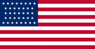
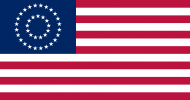
I'm assuming the U.S. flag is one of these?
View attachment 613639
View attachment 613640
Thank you!
These Fair Shores is indeed addressing some of my most disliked portions of
Our Fair Country.
Interesting, it seems the Dine/Navajo didn't move west ITTL?
You'd be correct. No land pressures from white settlers and no imperial states to push them, they are more or less left alone and separate from Mexico without much fanfare due to Mexico's inability to really project power in the region, and the United States' complete lack of care for westward expansion.
Seems kinda strange that Canada owns the Upper Peninsula of Michigan but not the Lower Peninsula.
Fairly easy to grab it during treaty negotiations in the 1840s. The Lower Peninsula would be a much harder sell.
The upper and lower peninsulas of Michigan weren't really attached at the hip before the former was given to the territory prior to statehood. They aren't really destined to be connected in the same way in the event of an alternate timeline. A fairer remark would probably be on why the Upper Peninsula went to Canada but the connecting land in Minnesota still ended up staying American.
Connecting land wasn't really an issue. At the time the borders were drawn, a connecting strip of land around Lake Superior would seem like an absolute complete waste of time. The Upper Peninsula was accessed primarily from the east, and by boat. For the British, there would have been nearly no desire whatsoever to push for a strip of land, then waste countless amounts of money to try and build a road that connected York (Toronto) with the Upper Peninsula. Boats were much cheaper.
I'm from Seattle, so ITTL I'm Canadian and from TTL's Seattle Equivalent? Also, why is New England's currency the pound instead of the dollar? Thirdly, sad to see America not achieving Manifest Destiny. Finally, what becomes of Aaron Burr (Jehovah's blessings be upon Him, All Hail)?
You'd likely remain in Seattle, which is still a city in Canada. The United States is an extremely insular country. Historically it did not export many goods, and has often kept to itself in absolute isolation (outside of the Caribbean). The lack of Empire-U.S.A. trade means that the pound remains the preferred currency for the Anglosphere. I, regrettably, have no information on Aaron Burr at the moment.
Great graphic, and the concept of a US whose population is more concentrated around the Mississippi River is definitely interesting. I’d assume that was caused by there not being an American Pacific Coast for settlers to migrate to.
Thank you! The Mississippi River becoming so dominate is a function of two things, the first is the constant drain of population from the East, and the increased focus on slavery as America's economic system. As such, the institution spreads much further and stays around much longer. Large plantations and small holdings make great use of the Mississippi River's basin and other river systems to transport goods to market, which is how New Orleans saw such explosive growth when compared to the more far-flung New York City. This growth and concentration on the river meant that industrial growth happened along the Ohio, becoming America's dense inner manufacturing hub. The rise of technology that makes living in the south more... bearable saw a shift of the population down the Mississippi River, and explosive growth of cities and towns along its banks. This was aided by a mega project to help control and tame the Mississippi River, making it easier to settle and control flooding.
This is such a stellar map! I'm going to ask a few questions and note some observations that I've had.
Where was the capital before Hamilton F.D.? I'm assuming it's Philadelphia, although the capital might be more in the south given their stronger hand.
What are the main differences in population density between OTL and TTL? From what I can see, there is a higher density in the Ohio and Mississippi rivers, and maybe a less dense Northeast?
Why are NY and NJ's populations declining?
The specifying of the year in the Anglo-American War of 1846 means that there is more than one. I'm assuming that US-UK relations aren't exactly the best.
With more people living in Louisiana, hurricanes could be more deadly and costly. It's also interesting to see Texas as a state in its largest extent.
A capital was founded along the banks of the Potomac River, Hamilton City in the District of Columbia, but such a venture did not last very long. Pressures from the British, along with a population moving west, saw the district dissolved and the territory retroceded to Maryland and Virginia. Hamilton City (just Georgetown and a few farms and cow pastures where the old city was) today is relatively small, but it's still the biggest population centre between Richmond and Baltimore.
Texas is the powerhous of the union it seems
Texas has 9,972,451 people, and is the 3rd most populous state in the Union. (As of the 2008 Census)
What is the political status of the Federal District?
The Hamilton Federal District has home rule, elects a Governor and has a legislature. It also has representation in the House of Representatives and the Privy Council, but it is not a state.


