You are using an out of date browser. It may not display this or other websites correctly.
You should upgrade or use an alternative browser.
You should upgrade or use an alternative browser.
The XK-BAM map series
- Thread starter Klime
- Start date
the fuck did you do to the coastlines?
Edit: and the lakes, too...
ooh gimmeI have QGIS shapefile for that. 90 perecent accurate.
Mind also doing the TNO version? The drop isn't that low so Italy and Libyan coast aren't connected, and the Balearics remain separate from the Spanish mainland. S0 around +/- 200 meter drop
OH MY GOD, YES. A VERSION OF ATLAN WHERE THE COASTS AREN'T ABYSSMALLY FUCKED.
The state and county boundaries of the State of New Mexico, as ordained by the state constitution drafted in May 1850, and approved by the population in a vote that took place on June 20th, 1850.
(The second map is purely for visualizing where the state was geographically. The map used is made specifically for 1-1-1850, and any changes to state, county, native reservation, or native land cession boundaries between 1-1-1850 and 6-20-1850 are not accounted for.)
Inner solar system planets/the Moon -
Darker areas are the waters, I just like having these unique colors. I used maps from 1Wyrmshadow1 https://www.deviantart.com/1wyrmshadow1 and Shadow-Dragon-777 https://www.deviantart.com/shadow-dragon-777
@XO Maenadicus made a wonderful topographic equirectangular map of Mars here in the Alternate Planets, Suns, Stars, and Solar Systems Thread, and I think it could be easily converted into a 2k-bam scale map. I would like to see more topographic maps of solar system bodies in general.
Does anybody have the new 2nd and 3rd level divisions for the Donetsk and Luhansk Oblasts on 8K BAM?
Does anybody have the new 2nd and 3rd level divisions for the Donetsk and Luhansk Oblasts on 8K BAM?
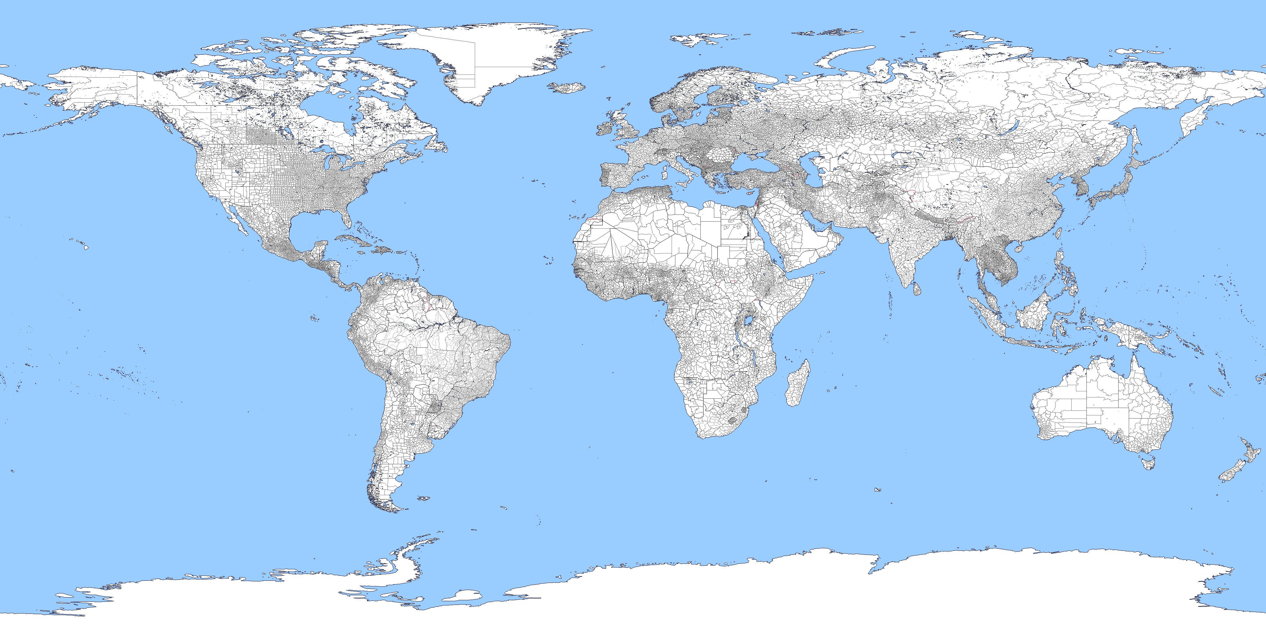
Thought a map of intermediate size between 2K-BAM and 8K-BAM could be useful, so here's 4K-BAM. I made this by reducing the scale of the 8K-BAM and tracing over it, so some borders or coastlines might not be as accurate as they were supposed to be, but those cases are minor. Edit: Fixed some bugs, please report any weird pixels or missing borders.
Last edited:
Oooh, really niceThought a map of intermediate size between 2K-BAM and 8K-BAM could be useful, so here's 4K-BAM. I made this by reducing the scale of the 8K-BAM and tracing over it, so some borders or coastlines might not be as accurate as they were supposed to be, but those cases are minor. Edit: Fixed some bugs, please report any weird pixels or missing borders.
I have thought of doing a 4k-bam too, what a concidence 👍
Nice!Thought a map of intermediate size between 2K-BAM and 8K-BAM could be useful, so here's 4K-BAM. I made this by reducing the scale of the 8K-BAM and tracing over it, so some borders or coastlines might not be as accurate as they were supposed to be, but those cases are minor. Edit: Fixed some bugs, please report any weird pixels or missing borders.
Anyway, I have an idea for a new map size: The 8PDE. It would be 2880x1440, as it's a nice round number, and one degree corresponds to an integer number (in this case 8) of degrees longitude or latitude.
That seems like an interesting idea. It's exactly 1/15 of VT-BAM size (which, IIRC, has 30 arcseconds to a pixel). Out of curiosity, is there any reason why you chose 7.5' per pixel?Nice!
Anyway, I have an idea for a new map size: The 8PDE. It would be 2880x1440, as it's a nice round number, and one degree corresponds to an integer number (in this case 8) of degrees longitude or latitude.
Because it's a bit bigger than the WK-Bam, whilst still being able to fit onto the forum. 6 pixels/° (2160×1080) is a little too small, while 10 pixels/º (3600×1800) is a little too big.That seems like an interesting idea. It's exactly 1/15 of VT-BAM size (which, IIRC, has 30 arcseconds to a pixel). Out of curiosity, is there any reason why you chose 7.5' per pixel?
Is there a water shed map like this but you know on the 8k or 2k and without all the colours, just rivers + watershed borders
qazse
Gone Fishin'
Mexico has a boo-boo - there's a very tiny gap in the Tamalupias - SLP border.Thought a map of intermediate size between 2K-BAM and 8K-BAM could be useful, so here's 4K-BAM. I made this by reducing the scale of the 8K-BAM and tracing over it, so some borders or coastlines might not be as accurate as they were supposed to be, but those cases are minor. Edit: Fixed some bugs, please report any weird pixels or missing borders.
Share: