Thank you, no admin versions would be nice for each time period. Especially as I understand it 1910 is done for external borders but not for internalThere is now.
You are using an out of date browser. It may not display this or other websites correctly.
You should upgrade or use an alternative browser.
You should upgrade or use an alternative browser.
The XK-BAM map series
- Thread starter Klime
- Start date
So I made a map of the Viceroyalty of the Río de la Plata. Please tell me if I made any mistakes.
https://drive.google.com/open?id=17bSfDsxMON4--guadftLV2ZRBlakBMAIMy work on Russia kind of stalled in Siberia because so many borders are defined by rivers and we don't have many rivers drawn on asian part of the map so im now basically working on drawing those missing rivers.
This file has river overlays set up for most of the world.
https://drive.google.com/open?id=17bSfDsxMON4--guadftLV2ZRBlakBMAI
This file has river overlays set up for most of the world.
Wow thank you i will be working from that
https://drive.google.com/open?id=17bSfDsxMON4--guadftLV2ZRBlakBMAI
This file has river overlays set up for most of the world.
Working on weekend i managed to do about half of mainland Asia (yes siberia is huge), im using your overlays as a base and when adding new rivers checking them from 3-4 sources so i takes some time, i hope to finish rest of the world in 2-3 weeks time, check them with regional maps to see if they need some fine tuning. After that im planning to send them to you, if you want to add something or correct something you see.
You're working on rivers? Can you do some work on the Q-bam rivers map? In which case please stop by here.Working on weekend i managed to do about half of mainland Asia (yes siberia is huge), im using your overlays as a base and when adding new rivers checking them from 3-4 sources so i takes some time, i hope to finish rest of the world in 2-3 weeks time, check them with regional maps to see if they need some fine tuning. After that im planning to send them to you, if you want to add something or correct something you see.
Is there a sorta "prerelease" for the stuff you've been doing in russia and asia (especially in european russia)? I would really appreciate that since I need especially Eastern EuropeWorking on weekend i managed to do about half of mainland Asia (yes siberia is huge), im using your overlays as a base and when adding new rivers checking them from 3-4 sources so i takes some time, i hope to finish rest of the world in 2-3 weeks time, check them with regional maps to see if they need some fine tuning. After that im planning to send them to you, if you want to add something or correct something you see.
Hi, I made this 2K-BAM map of East Asia and the Pacific in December 6, 1941 for another project of mine. I might later expand this into a full world map, but for now I would like to hear some constructive criticism and if I have made any mistakes. Please note that several borders were drawn manually without any reference maps, so they may be slightly inaccurate.
P.S. Does anyone have good sources on the administrative divisions of the Dutch East Indies? I couldn't find any so I used the subdivisions from other maps like the WorldA.
Deleted member 121481
I have done some work on Central Europe in 1855 and France in 1788 maps. I kept the original borders for easier orientation and the historical ones are in blue. The red/orange borders/spots are spots that haven't done or checked. The light blue one in Bukovina is a river. I came across an issue with tiny states and borders. For example the panhandle in Bavaria, the resolution doesn't allow me to draw it accurately in the right spot, so it's left unfinished. And as I've stumbled over more of these places I gave up on finishing the maps. But I wanted to share them with you, in case someone would want to use them for their own work.
The 1855 one is mostly done, the only major unfinished things are Prussia's eastern and internal borders, Principality of Transylvania and Austrian military frontier + few unchecked spots. I have tweaked some borders here and there, from the top of my head the borders of Krakow, Galicia-Lodomeria, Bohemia-Moravia, southern borders of Austria and some borders in Germany. There were also minor mistakes in coastlines of Montenegro and Po river delta when I was checking borders with satellite google maps, so that's fixed too.
The map of France in 1788 is 40-50% done. Each province has its own color except the ones completely in the grey zones. The historical borders should go loosely through the light grey areas. The borders are based on maps made by user Poulpy and uploaded on wikimedia commons and wikipedia.
Someone should remake the borderpool but on this projection.I have done some work on Central Europe in 1855 and France in 1788 maps. I kept the original borders for easier orientation and the historical ones are in blue. The red/orange borders/spots are spots that haven't done or checked. The light blue one in Bukovina is a river. I came across an issue with tiny states and borders. For example the panhandle in Bavaria, the resolution doesn't allow me to draw it accurately in the right spot, so it's left unfinished. And as I've stumbled over more of these places I gave up on finishing the maps. But I wanted to share them with you, in case someone would want to use them for their own work.
The 1855 one is mostly done, the only major unfinished things are Prussia's eastern and internal borders, Principality of Transylvania and Austrian military frontier + few unchecked spots. I have tweaked some borders here and there, from the top of my head the borders of Krakow, Galicia-Lodomeria, Bohemia-Moravia, southern borders of Austria and some borders in Germany. There were also minor mistakes in coastlines of Montenegro and Po river delta when I was checking borders with satellite google maps, so that's fixed too.
The map of France in 1788 is 40-50% done. Each province has its own color except the ones completely in the grey zones. The historical borders should go loosely through the light grey areas. The borders are based on maps made by user Poulpy and uploaded on wikimedia commons and wikipedia.
View attachment 449533 View attachment 449555
So I made a 1960 Ethiopian Provinces 2K-Bam patch, because why not.

Might do more Ethiopian patches (1935 and 1987)
Might do more Ethiopian patches (1935 and 1987)
Made the same patch but for the 8K Bam. Yeah I know basically nobody will use it but hopefully I can start a trend of doing historical administrative patches.

Not a joke, but it's nonetheless hilarious: on the 1930 patch Lake Chad is literally 1 pixel north of its position on the base 8K-BAM map. 
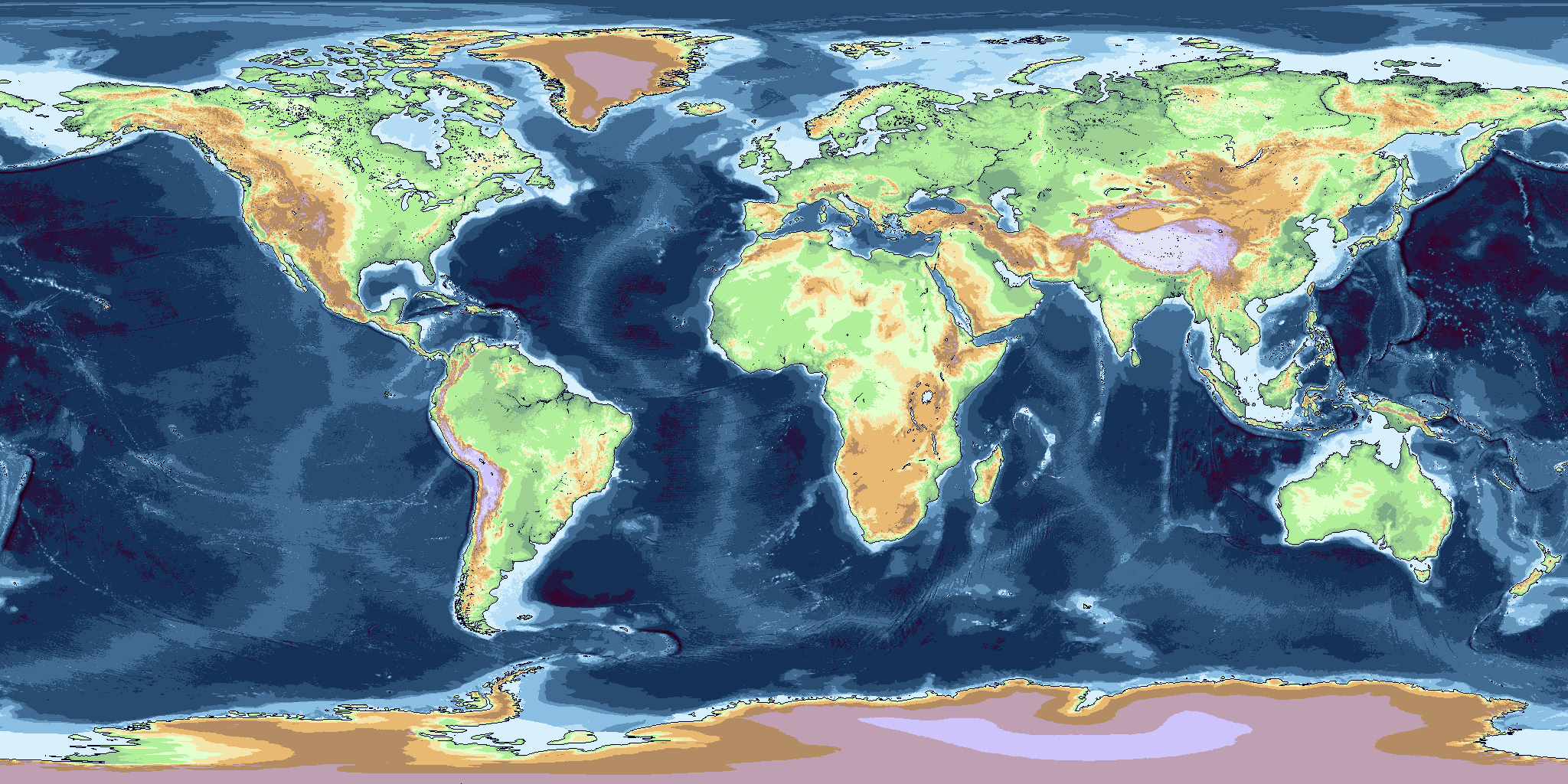
A couple days ago tungsterismapping posted on the main map thread a series of relief maps in the 2K-BAM scale. I translated and sort of de-bugged them to fit into the 2K-BAM, and here's the result (might still contain pixels that are off).
EDIT: Fixed most bugged pixels.
EDIT: Fixed most bugged pixels.
Last edited:
A couple days ago tungsterismapping posted on the main map thread a series of relief maps in the 2K-BAM scale. I translated and sort of de-bugged them to fit into the 2K-BAM, and here's the result (might still contain pixels that are off).
EDIT: Fixed most bugged pixels.
I really admire all the work you've done here with the bathymetry. I know it's a thread about the XK-Bam or 2K-Bam maps, but i really hope one day i can find a map just like that with the Q-Bam form
Share: