Reworked Liaoning's counties, assemble with jefe's shot at Jilin and Heilongjiang. Also did some portions of Inner Mongolia and Hebei province that were part of Manchuria. Would be doing more of Inner Mongolia soon.
You are using an out of date browser. It may not display this or other websites correctly.
You should upgrade or use an alternative browser.
You should upgrade or use an alternative browser.
The VT-BAM project
- Thread starter VT45
- Start date
De facto speaking, Daxing'anling Prefecture, Heilongjiang controls part of Oroqen Banner in Inner Mongolia, in the form of Jiagedaqi and Songling Administrative Zones.View attachment 714659
Reworked Liaoning's counties, assemble with jefe's shot at Jilin and Heilongjiang. Also did some portions of Inner Mongolia and Hebei province that were part of Manchuria. Would be doing more of Inner Mongolia soon.
Hmm, something has been bugging, @Raazossaku, @Generaloberst Lizardon, and @jefe, what are the sources are you using for your patches for China? I believe it would be a good idea to use the same source as I noticed some interesting issues.
For Raazossaku, the provinces and coastlines are different:

For Lizardon, there is province differences as well as very minor edits of the coastline and what appears to be stray pixels along the Korean border:

For Jefe, their patches seems to be the most compatible with the current edition of the map. That's why I'm asking what are the sources used and see if you three can agree on a single source to go with.
For Raazossaku, the provinces and coastlines are different:
For Lizardon, there is province differences as well as very minor edits of the coastline and what appears to be stray pixels along the Korean border:
For Jefe, their patches seems to be the most compatible with the current edition of the map. That's why I'm asking what are the sources used and see if you three can agree on a single source to go with.
Last edited:
@Iustinus Tempus I'm gonna do a rework of Liaoning once I finish off the Republics of Tatarstan and Chuvashia. As for what I use to make my maps, I use a variety of sources but mainly an overlay given to me by user @Klime
Last edited:
@Iustinus Tempus as for me, I just use the raw reference that came along for tracing admin divisions plus a QGIS export for townshipsHmm, something has been bugging, @Raazossaku, @Generaloberst Lizardon, and @jefe, what are the sources are you using for your patches for China? I believe it would be a good idea to use the same source as I noticed some interesting issues.
For Raazossaku, the provinces and coastlines are different:
View attachment 714699
For Lizardon, there is province differences as well as very minor edits of the coastline and what appears to be stray pixels along the Korean border:
View attachment 714701
For Jefe, their patches seems to be the most compatible with the current edition of the map. That's why I'm asking what are the sources used and see if you three can agree on a single source to go with.
Last edited:
I think you are misunderstanding something quite fundamental about why I decided to redo these. The provinces as they were with the "current edition of the map" are completely misaligned with reality, which is why they had to be redone.Hmm, something has been bugging, @Raazossaku, @Generaloberst Lizardon, and @jefe, what are the sources are you using for your patches for China? I believe it would be a good idea to use the same source as I noticed some interesting issues.
For Raazossaku, the provinces and coastlines are different:
View attachment 714699
As for the coastline differences, I found that while doing them that the coastlines reflect features that no longer exist or have been reclaimed by land (this is expected in the Jiangsu region, as most of it is the result of sediment being built up in historical times in the first place). This usually confirmed using the most up-to-date satellite images I can find.
For my sources, I'm doing it manually in an iterative process. The base trace is simply based on transformed Google Maps and OpenStreetMap data, taking each square of 15 minutes latitude x 15 minutes longitude, and then cross referenced with maps from official Chinese governmental sources such as local county/municipality websites and surveying maps.
Edit: You can see pretty much the exact same discrepancies between this "current edition" and the 8k-BAM, based on finn's comparison here. Considering I adopted a completely different process and didn't use the 8k-BAM as reference during creation, I think this demonstrates the issue the pre-existing VT-BAM had in China, and that my fix, which I absolutely do not claim to be perfect, is far closer to reality that it was, which is the ultimate goal.
Last edited:

just a lil fix to your mapProgress as of right now, might not be accurate but that'll do, making a division progress map aswell.
Actually, it doesn't matter about the divisions for this one, it's about how complete the map is in 1st levels.
Last edited:
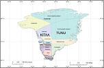
Municipalities (and two divisions of the national park) of Greenland prior to 2009. The larger labels indicate regions/landsdele.May I ask what are these, I might add them if I can.
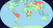
Countries that are undone or are partially done list (not counting colonies & only 1st levels)
This might be helpful.
Countries completely undone:
Central African Republic
Gabon
Marshall Islands (probably because it's too tiny)
Monaco (same as Marshall Islands)
Nauru (Probably not on the map)
Norway
Republic of the Congo
Tuvalu (same as Monaco)
Countries partially done:
Angola
Brazil
China
Colombia
Democratic Republic of the Congo
Ethiopia
Indonesia
Russia
Last edited:
Reworked Manchuria/Dongbei patch. Managed to have recovered this from my hard drive since I fucked up my laptop's Windows OS.
Share: