The VT-BAM project

Hi guys, I'm new to this and I can't read 111 pages right now, so how well is the project going?
It is slowly progressing. Most countries have the first level administration boundaries, many countries second and third level administrative boundaries.
There is a lack of historic maps at the moment.
What map do you need/want to create?
 
It is slowly progressing. Most countries have the first level administration boundaries, many countries second and third level administrative boundaries.
There is a lack of historic maps at the moment.
What map do you need/want to create?
I see that the answer was quick, I only asked to be aware of the project, personally at the moment I can not participate or help, but if at some point this will let you know.
 
It is slowly progressing. Most countries have the first level administration boundaries, many countries second and third level administrative boundaries.
There is a lack of historic maps at the moment.
What map do you need/want to create?
Hey, thanks for the response. What's the latest state of the map for China and/or East Asia?
 
OTL - Different Proposals for the Mexican Cession, according to the Atlas of the Historical Geography of the United States, converted to the VT-BAM (Pt.1) https://dsl.richmond.edu/historicalatlas/94/a :
JDKf4st.png

Pt.2, aka the version that is actually practical to use:
5pzLYDA.png
 

Crazy Boris

Banned
I never realized before quite how uneven "straight" state borders are before this map was made.

There were a ton of surveying errors in the eastern states when the borders were being drawn up, and any attempt to straighten them has just ended up either staying where they are or altering them just a little bit, but not enough to be straight since states are gonna be reluctant to hand over any land to their neighbors.
 
Instead of fixing or getting a more accurate Interwar Poland (which I should work on soon), here are the Districts of East Germany/ German Democratic RepublicView attachment 653925

Also several minor corrections are done for the 1815 map, (I guess I should repost it soon). I guess I won't work on Morroco and Algeria, since I totally lack the knowledge for the area, and need to read some stuff to better understand the region.
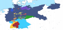
You don't have to fix German-Polish border in the Interwar Period. I fixed it :).
 

Attachments

  • Weimar_Republic.png
    Weimar_Republic.png
    57.6 KB · Views: 668
Here is a work-in-progress of the Confederation of the Rhine around 1812 or shortly before the Russia campaign ...
fedrhine1812north.png

I focused mostly on the kingdom of Westphalia and tried to get the correct borders of France.

Here are some minor patches for the post Vienna map.
Added an enclave of Brunswick and the two minor states between Tuscany and the Papal States and between Portugal and Spain. Also some corrections for the borders in the southern Rhineland.
hannoverpatch.png

minorpatches.png
 
Last edited:
I still have the zip-file of the map as of early 2019, did anyone make a file that has *everything* done since then? In my version, several countries weren't even started.
 
Top