The VT-BAM project

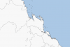
Tried to make a sketch for a hypothetical civil war in Austria in 1934 by using VT-BAM
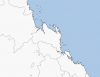
In OTL the Austro-Fascists defeated Social Democrats in several Austrian cities, here I tried to predict areas of control after several Social Democratic victories in the first weeks of such a civil war.


austriancivilwar1934.png
 
Red mean only First-level administrative country subdivisions are done?
Green means Second-level administrative country subdivisions are done?
Blue means Third-level administrative country subdivisions are done?
Red means everything is not done eg: 1st level only or only national borders
Green means it's been done according to key
Blue Means it's been improved later on
 
Two State Irredentism maps I have done so far. Try not to pay attention to the exact border colors, as I used different colors throughout them simply so that you can see them well. For New Jersey, Blue is West Jersey, and Green is East Jersey, and red is the area that was transferred between them.
 

Attachments

  • Maine.png
    Maine.png
    11.7 KB · Views: 545
  • New Jersey _ Historical.png
    New Jersey _ Historical.png
    3 KB · Views: 555
Here are two patches for the Oregon Country, and the proposed State of Deseret.
 

Attachments

  • Deseret.png
    Deseret.png
    27.9 KB · Views: 535
  • Oregon Country.png
    Oregon Country.png
    49.9 KB · Views: 579
Here are three patches for the Gadsden Purchase, the Louisiana Purchase, and the Republic of Texas.
 

Attachments

  • Gadsden - OTL.png
    Gadsden - OTL.png
    4.8 KB · Views: 532
  • Louisiana.png
    Louisiana.png
    64.8 KB · Views: 632
  • Republic of Texas.png
    Republic of Texas.png
    23.7 KB · Views: 605
So while looking at the areas that I need for my timeline map, I noticed this oddity with the mouth of the Amazon. It looks like a line or two is missing in some places, but in others it looks fine. I should note that this line is the edge of the two images that form this area. I personally think that it was accidentally cropped off. Has this already been fixed and I simply wasn't aware? Is this on purpose (I doubt it). Or has this so far gone unnoticed? (I drew tiny red arrows where I see the issue)
 

Attachments

  • Amazon Mouth.png
    Amazon Mouth.png
    1.8 KB · Views: 521
okay, this seems to be an issue in other areas as well, I noticed on Australia that there is the white bordering ocean again, and decided to compare the threadmarked full Australia, with the version that is cut up from that google drive, and I noticed this issue, which is that I think one is 1 or 2 pixels bigger than the other, looking at the state lines, everything seems to be shifted at an edge, where they are duplicated slightly and shifted slightly. in this case, the whole picture of Australia seems to be more accurate. The issue_Australia files are demonstrating that they line up until a certain line, and the divided/whole australia files show the state lines, which are obviously duplicated. In conclusion, I believe that not only are there slight issues with pixels floating around, but that the 3600*3600 square tiles are faulty in at least a couple areas (at least the ones in the google drive).
 

Attachments

  • issue_Australia.png
    issue_Australia.png
    9.6 KB · Views: 356
  • issue_Australia2.png
    issue_Australia2.png
    6.9 KB · Views: 332
  • divided australia issue.png
    divided australia issue.png
    576 bytes · Views: 322
  • whole australia nonissue.png
    whole australia nonissue.png
    556 bytes · Views: 385
I'm not trying to be overbearing or picky, you guys are doing a great job and are quite underappreciated, I just want to make sure that you are aware of this.
 
Top