You are using an out of date browser. It may not display this or other websites correctly.
You should upgrade or use an alternative browser.
You should upgrade or use an alternative browser.
The VT-BAM project
- Thread starter VT45
- Start date
Nice to see more and more people creating VT-Bam maps.
@Anagnod I recommend using one of the standardized color schemes.
@Anagnod I recommend using one of the standardized color schemes.
Thanks but I prefer to create my own as I go alongNice to see more and more people creating VT-Bam maps.
@Anagnod I recommend using one of the standardized color schemes.
Alex Richards
Donor
Nice to see more and more people creating VT-Bam maps.
@Anagnod I recommend using one of the standardized color schemes.
It's the Holy Roman Empire, You're going to need to create your own scheme regardless.
I am intrigued by the Romanian divisions there. Can you show me a full version of the provinces in Moldavia and Wallachia?
They are from @Zurirach Adankar 's mapI am intrigued by the Romanian divisions there. Can you show me a full version of the provinces in Moldavia and Wallachia?
Further Update for my balkanization map.
(Northern Ireland, some parts of Iberia, Schleswig-Holstein, the Balkans, Poland and the Baltics )
Additional I added my work-in-progress QBAM for areas outside of Europe. Sadly I lack the knowledge to have the same level of balkanization on other continents.
Sadly the full image is too large for the forum, therefore I split it.
Feel free to ask questions. If you are specially interested in a region, I can add a regional map with explanations of the different countries and vassal states and their backgrounds.
Feel free to add additional suggestions!
View attachment 820467
View attachment 820468
View attachment 820469
Alex Richards
Donor
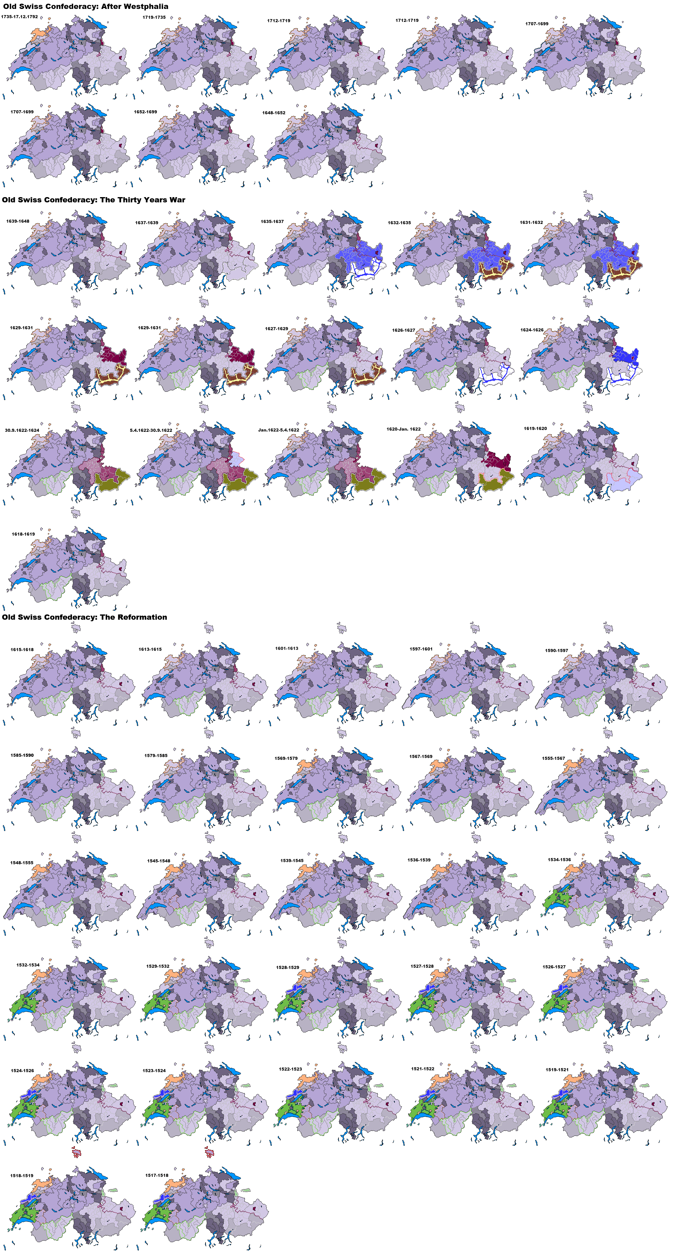
View attachment 829647
Switzerland 1560
Edited Switzerland; Added Mulhouse and the Rhine lands, added Rottweil and reduced Schaffhausen
The Aargau and Ticino areas are completely wrong for this period I'm afraid, and I don't really think it's worth indicating the difference between the Forest Cantons and the City Cantons so much as between the cantons and subject territories.
This is a few years old now, but should still be useful. I've kept on thinking I should revise it to demonstrate the bits of the City Cantons that were subject territories in the same way mind.
I dug further into Moldavia, this is the internals based on this; https://commons.wikimedia.org/wiki/File:Moldova_(1483)-en.pngI am intrigued by the Romanian divisions there. Can you show me a full version of the provinces in Moldavia and Wallachia?
How does this revision of Switzerland 1560 look?The Aargau and Ticino areas are completely wrong for this period I'm afraid, and I don't really think it's worth indicating the difference between the Forest Cantons and the City Cantons so much as between the cantons and subject territories.
This is a few years old now, but should still be useful. I've kept on thinking I should revise it to demonstrate the bits of the City Cantons that were subject territories in the same way mind.
Alex Richards
Donor
OK there's a few issues there.
-Vaud was part of the Canton of Bern, as was that are of what's now Aargau that wasn't under joint rule.
-That protectorate area south of Lake Geneva was part of the subject territories of the Sieben Zenden- note that not all the Upper Valais was a full member.
-Bern, Zurich and Luzern were all City cantons as well. Or if you're using that key, then Solothurn, Fribourg and Basel were all full cantons.
-The northern part of Schwyz was non-voting subject territories of that Canton, as were the valley and upper Ticino for Uri.
-All those other bits of the Ticino were separate in the same way as the bits of Baden were.
-The Abbey of St. Gallen was an associate state
-Werdenberg in the Rheintal was a non-voting part of Glarus.
It's an extremely complex situation to be fair.
1. I noticed there were some inconsistencies in North America with certain borders, specifically in Louisiana Virginia and Utah, so I've been working on a thing where I basically re-connect the pieces that have been posted in a sensible, as in not overlapping really weirdly, manner. Which I'm pretty much done with except for...
2. I HATE GREENLAND I HATE GREENLAND I HATE GREENLAND I HATE GREENLAND
3. Also I gave my own go at the Bahamanian district borders since everywhere I look seems to disagree. Using official election constituency maps as of 2017 (closest I could find but it seems that they haven't been changed since then, fingers crossed) and local government acts which divies up the districts along constituency borders.
Northern Italy any time soon?North Africa 1560
View attachment 831321
")
Working on the Ottoman E atm, Italy as soon as I update SavoyNorthern Italy any time soon?
For any with a passing interest, this is the WIP of my 1560 map
Ottoman Empire now added.

From my 1560 WIP
The Spanish NetherlandsView attachment 832710
House of Albret;- Navarre + French fiefs 1560
View attachment 833161
These should also be here
@Anagnod
It's a good map, but I can see several errors (if this is OTL).
·For the Crown of Castille, the internal subdivision was this: https://es.wikipedia.org/wiki/Archivo:Provinces_Crown_of_Castile_1590.svg (although this map has the error of Olivenza y Taliga on the Portugal border)
·Portugal should include the cities of Olivenza and Taliga (currently on Spain)
·The internal divisions of Catalonia, Aragon and Valencia are simply just wrong, also Catalonia includes the Fenolleda, which was part of France: https://ca.wikipedia.org/wiki/Fenolleda
·Valencia is missing the Racó d'Ademús, an exclave (https://ca.wikipedia.org/wiki/Rac%C3%B3_d%27Adem%C3%BAs), and the city of Caudete, another exclave (https://ca.wikipedia.org/wiki/Cabdet), but includes Villena and Sax, which where not part of the Kingdom (except between 1304-1369) (https://ca.wikipedia.org/wiki/Villena, https://ca.wikipedia.org/wiki/Saix) and the Plana de Utiel comarca, which was part of Castille except for the cities of Sinarcas and Chera (https://ca.wikipedia.org/wiki/Plana_d'Utiel) and the small village of Casas del Río (small "triangle" south of Requena).
The Spanish territory held in Oran is exagerated, and the spanish Tunez is just wrong.
Also, the territories of the Hispanic Crown should be marked with different colours or with darker borders, because the relations between the Crown of Castile and the different territories of the Crown of Aragon, and between the territories of the Crown of Aragon among themselves, were to have the same king, but there was no administrative relationship between them.
TY, I shall work on this@Anagnod
It's a good map, but I can see several errors (if this is OTL).
·For the Crown of Castille, the internal subdivision was this: https://es.wikipedia.org/wiki/Archivo:Provinces_Crown_of_Castile_1590.svg (although this map has the error of Olivenza y Taliga on the Portugal border)
·Portugal should include the cities of Olivenza and Taliga (currently on Spain)
·The internal divisions of Catalonia, Aragon and Valencia are simply just wrong, also Catalonia includes the Fenolleda, which was part of France: https://ca.wikipedia.org/wiki/Fenolleda
·Valencia is missing the Racó d'Ademús, an exclave (https://ca.wikipedia.org/wiki/Rac%C3%B3_d%27Adem%C3%BAs), and the city of Caudete, another exclave (https://ca.wikipedia.org/wiki/Cabdet), but includes Villena and Sax, which where not part of the Kingdom (except between 1304-1369) (https://ca.wikipedia.org/wiki/Villena, https://ca.wikipedia.org/wiki/Saix) and the Plana de Utiel comarca, which was part of Castille except for the cities of Sinarcas and Chera (https://ca.wikipedia.org/wiki/Plana_d'Utiel) and the small village of Casas del Río (small "triangle" south of Requena).
The Spanish territory held in Oran is exagerated, and the spanish Tunez is just wrong.
Also, the territories of the Hispanic Crown should be marked with different colours or with darker borders, because the relations between the Crown of Castile and the different territories of the Crown of Aragon, and between the territories of the Crown of Aragon among themselves, were to have the same king, but there was no administrative relationship between them.
Do you have any data on Tunez, I estimated based on the towns/cities I KNEW were taken, anything else would be appreciated
@Anagnod
Wikipedia has a good list of the cities and the dates on which they were controlled (https://es.wikipedia.org/wiki/Imperio_español#África). In addition, control of cities in the Tunis area was superficial and generally confined to the city limits. The population of the cities were natives of the area.
By 1560 the only controlled territories were: the island of Djerba (which was lost that same year), Bizerte and Tunis (including La Goulette).
Share: