The People's Socialist Atlas

The People's Socialist Atlas - December 21st, 2017
So, I'm leaving the forums. I know it doesn't really matter much, but this place has been a big part of my life for over three years. I figured, if I was going to close this chapter of my life to move to other things, I needed to close things out with a bang. And what better bang than a Christmas present to strangers?

I decided to write an atlas. The People's Socialist Atlas is an atlas made from the perspective of a communist United States that underwent a revolution in the 1920's. The PoD of the atlas is that there was a larger and more successful Paris Commune, which lead to increased paranoia around the world. It's a full book. It's over 200 pages, and over 50,000 words. I began writing it in 2016 with the intention that it would be done by the beginning of 2017. It didn't. It took me up until today to finally finish this project. It was a collaboration with @Noravea, who put up with my incessant nagging. I received a lot of help with writing from @Asami and @Fox-Fire, who were both extremely supportive of my endeavor.

I'm going to post one part of the atlas every day from today until Christmas, when the whole thing will be posted along with every single map.

There are thirteen maps in the atlas. Four I'm extremely proud of, and all took me hours upon hours to make. That's why I'm posting the atlas here. In each post, there should be more than one map, which I think qualifies it to belong in this thread.

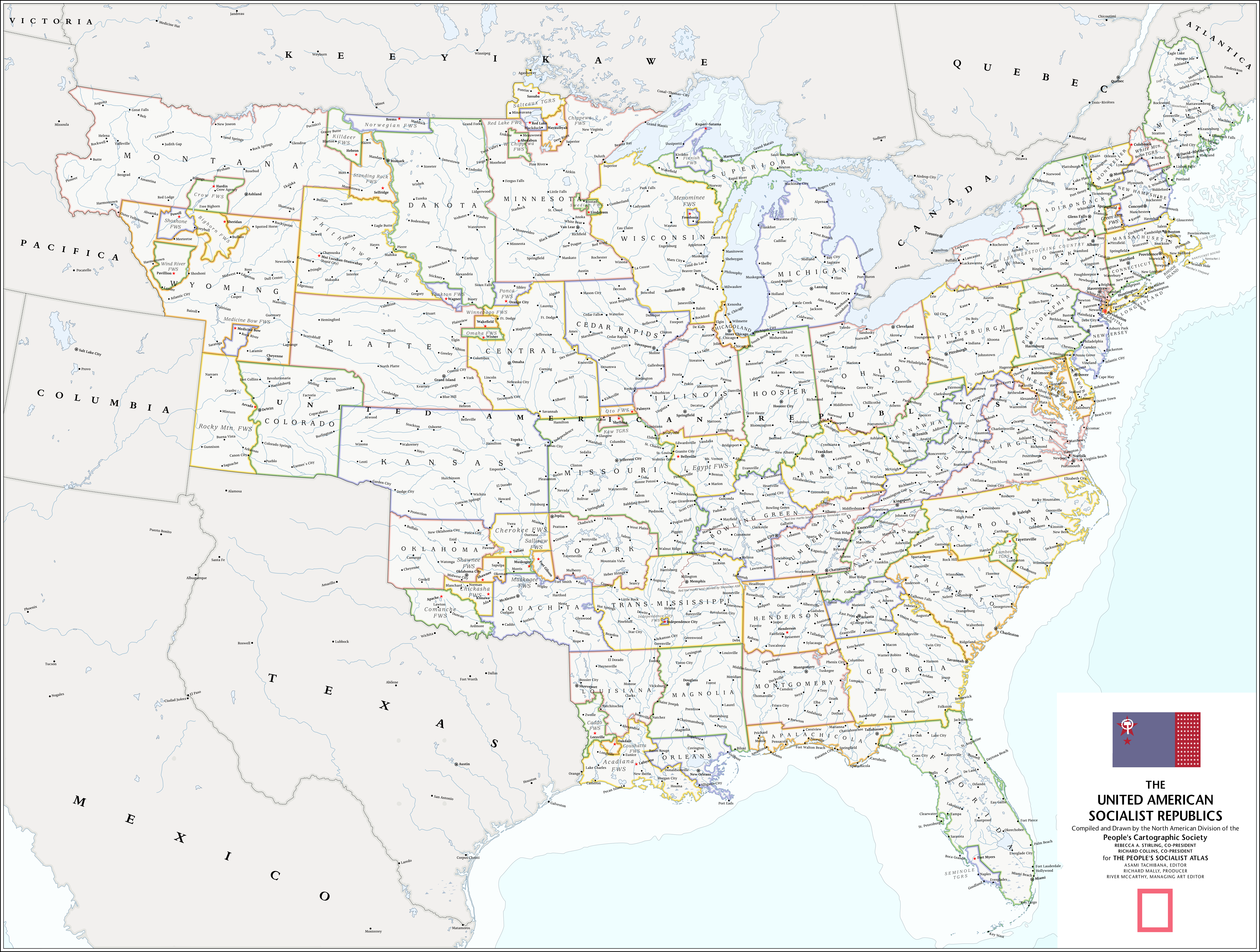
The rest of the writing should speak for itself. Today, I'll be posting pages 1 to 74 of the Atlas. That's the first half of the "American History" section, and includes maps of the American Revolution and the United American Socialist Republics. CLICK ON THE IMAGE BELOW TO CHECK OUT ALL THE PAGES, or click here. I'm very excited for you all to see what I've been working on for the past few months. :) I had a great time working on it, so I hope you all have an even better time reading it. Please, enjoy!


Today's maps:

The United American Socialist Republics (it's too big to post here, so click on the image to see the full thing!):

The American Revolution:
 
Last edited:
Is Rebecca Stirling with the star for her signature a reference to Rebecca Sugar?

Great alternate history, and I like the misinterpreting of Marx in lines talking about 'utopias' and the UASR being a stepping stone to a Marxist 'utopia' - it feels very fitting.
 

chankljp

Donor
This looks very interesting. Will be very curious to find out if the other American successor states will also be socialist, or will they be something else. Looking forward to read more about this world that you have created!

Also, I noticed that: (1) For the USA remnant operating out of Utah, on the official UASR map it was labelled as 'Columbia'. Will be curious to find out more about the political situation between the two countries; (2) The city of Washington DC kept it's original name. Does the UASR still use it as their capital, or did they moved the capital to say... Chicago?
1) I elaborate more on this in future parts, though thinking back to it it might not be the most clear piece of writing! If you find yourself confused about the situation when the Columbia pages come out, just tell me and I'll explain more. 2) Washington DC was actually renamed after the revolution to Vetustia. The UASR's capital is in the Capital ASR, which is a bigger version of New York City. :)

Absolutely beautiful. I want an actual copy of it.
You might get your wish someday soon! ;)
 
Fucking hell, this is brilliant.

I assume you'll be going into the precise nature of the "near-successful" Paris Commune in a future instalment, because it strikes me as... questionable in terms of probability. The Republic did have an army and control of the entire rest of France.
 
This first map in your atlas is really good, so good I have nothing but nitpicks. And that is--why all the renamed cities? More than just the usual communist tradition of renaming towns and cities after revolutionary leaders. Like Nashville, TN, why is it called Music City, when the name Music City wasn't given to Nashville until 1950 IOTL thanks to the Grand Ole Opry which presumably wouldn't exist in the same form in a communist state. And what's the deal with the partioned Tennessee ASR? I'm curious to know, is there a link to a TL somewhere to explain? I wonder what happened to Murfreesboro, TN too, since it's at the center of former Tennessee, and was a lot more important than other cities listed on the map in 1920 and would serve to benefit by the borderline being drawn in that place. Was there another major battle at Stones River which ended in the place being razed?

Overall, a very interesting piece of AH.
 
Absolutely brilliant. I have a few questions, though:

1. What fonts did you use? It's exactly like National Geographic's.
2. What happened to Niagara Falls? There's a big lake there, north of Buffalo, where Grand Island would be.
3. What about Detroit?
4. The renamed cities are great and perfectly in keeping with Communist ideology. In fact I'd almost expect more cities named after heroes of the Revolution and the like.
5. What about closed cities? Do they exist? I suppose they wouldn't appear on any map. However, Oak Ridge, Cumberland is clearly shown. Perhaps that could have been something like Klaus Fuchsville-21?
6. You've misspelled "siege" on the January 1924 map. "Seige of the 'Texas Soviet'". :)
7. Is Vetustia's name derived from the Latin vetus, old?
8. Any plans for a searchable PDF version? It'd be easier to find answers with that...

I did read the narrative but not too closely, so maybe you've answered a couple of those questions; sorry if I've missed the answers. And sorry I have so many questions!

Really looking forward to more, it's so professionally done that the level of immersion is superb. (I almost wanted to ask my questions in character...)
 
Last edited:
The map is spectacularly executed, but a lot of it, especially the West, is really confusing. I don't want to pick things apart without understanding what you're trying to do, but when exactly is the POD? 1870? What is a "FWS"? Because the boundaries of the ones with Native American names don't have much to do with logical tribal area boundaries in the late 19th century.
 
The map is spectacularly executed, but a lot of it, especially the West, is really confusing. I don't want to pick things apart without understanding what you're trying to do, but when exactly is the POD? 1870? What is a "FWS"? Because the boundaries of the ones with Native American names don't have much to do with logical tribal area boundaries in the late 19th century.
I think FWS is Free Workers' State.
 
The map is spectacularly executed, but a lot of it, especially the West, is really confusing. I don't want to pick things apart without understanding what you're trying to do, but when exactly is the POD? 1870? What is a "FWS"? Because the boundaries of the ones with Native American names don't have much to do with logical tribal area boundaries in the late 19th century.
I understand what you mean. Some of it was admittedly done for the rule of cool, because come on, if you had to work on something for hundreds of hours, why not try to make it at least fun? Although, I did try to base most of the FWSs on tribal regions either in the modern day or in 1865. They should be at least somewhat accurate, and if not, then it only involves some minor tribal movements ITTL (which did occur) to make them accurate. The UASR was where I started with this TL, so it's probably regions like those you're pointing out that are the most implausible parts of the whole project.
 
I understand what you mean. Some of it was admittedly done for the rule of cool, because come on, if you had to work on something for hundreds of hours, why not try to make it at least fun? Although, I did try to base most of the FWSs on tribal regions either in the modern day or in 1865. They should be at least somewhat accurate, and if not, then it only involves some minor tribal movements ITTL (which did occur) to make them accurate. The UASR was where I started with this TL, so it's probably regions like those you're pointing out that are the most implausible parts of the whole project.

The map looks good and I won’t nitpick it apart unless you’d like me to.
 
Absolutely brilliant. I have a few questions, though:

1. What fonts did you use? It's exactly like National Geographic's.
2. What happened to Niagara Falls? There's a big lake there, north of Buffalo, where Grand Island would be.
3. What about Detroit?
4. The renamed cities are great and perfectly in keeping with Communist ideology. In fact I'd almost expect more cities named after heroes of the Revolution and the like.
5. What about closed cities? Do they exist? I suppose they wouldn't appear on any map. However, Oak Ridge, Cumberland is clearly shown. Perhaps that could have been something like Klaus Fuchsville-21?
6. You've misspelled "siege" on the January 1924 map. "Seige of the 'Texas Soviet'". :)
7. Is Vetustia's name derived from the Latin vetus, old?
8. Any plans for a searchable PDF version? It'd be easier to find answers with that...

I did read the narrative but not too closely, so maybe you've answered a couple of those questions; sorry if I've missed the answers. And sorry I have so many questions!

Really looking forward to more, it's so professionally done that the level of immersion is superb. (I almost wanted to ask my questions in character...)
1. The Nat-Geo-esque font was Stone Sans. Nat Geo's actual font is a trade secret, but Stone Sans is apparently the closest one can get to the real thing.
2. I probably just made a mistake on the basemap, haha.
3. It was renamed to Motor City.
4. Yeah, that's true, although I think in recent years there's been a rejection of some of the earlier communist leaders, like Allen and Sellers specifically. Plus, it's kind of a thing in this TL that there's a "DeWitt Street" in every town with over 10,000 people. :p
5. If you look on the map, you'll see something called the "Independence City FWS". Independence City was essentially a closed city, although closed cities technically don't exist in the UASR. In the modern day, what once were closed cities, or at least cities locked off to non-whites (these would have been popular in the Sellers era), have been desegregated and reintegrated.
6. Ah, shit.
7. It does! :D It was meant to be DeWitt's way of saying "out with the old, and in with the new".
8. Yeah, I think so. I'll probably post a PDF here after the full version is finished and edited.
 
Top