Anyways, here's a WIP of a cover of a 1919 world map in WorldA format

You are using an out of date browser. It may not display this or other websites correctly.
You should upgrade or use an alternative browser.
You should upgrade or use an alternative browser.
The NextGen OTL Worlda Series
- Thread starter hadaril
- Start date
And useful. Could it become a series, starting in 1992 and hopping from decade to decade? (1992, 2002, 2012, 2022, perhaps 1982)Duly impressive.
EDIT: is it just me, or 1919 east-center Europe almost looks medieval?
Last edited:
Of course , it is the mighty King Vladimir ''Lenin'' the First who will come to save the faith in Europe!And useful. Could it become a series, starting in 1992 and hopping from decade to decade? (1992, 2002, 2012, 2022, perhaps 1982)
EDIT: is it just me, or 1919 east-center Europe almost looks medieval?
Oh, I see... so we are dealing with Zar Vladimir II now?Of course , it is the mighty King Vladimir ''Lenin'' the First who will come to save the faith in Europe!
Last edited:
Of course! I hope your not suggesting he is the illegitimate ruler of the people?Oh, I see... so we ar dealing with Zar Vladimir II now?
Naah... it's Russia that's illegal (since Ronald Reagan excommunicated it)Of course! I hope your not suggesting he is the illegitimate ruler of the people?
Last edited:
because I'm a jealous bitch I thought I'd give an update given it's been like 6 months since I've released anything -- I'm still doing stuff!! too much stuff, really, it's gonna be quite something special when complete but it's still quite annoying to do, lol
Looking forward to it - you’ll always be the OG of stylized historical WorldA patchesbecause I'm a jealous bitch I thought I'd give an update given it's been like 6 months since I've released anything -- I'm still doing stuff!! too much stuff, really, it's gonna be quite something special when complete but it's still quite annoying to do, lol
Patch for dried up lakes and reservoirs
Had to slightly change the borders of Cameroon and Nigeria so that everything matches
Last edited:
Anyone has a WorldA of sea level rise of 2 meters? (also maybe 3 meters, but 2 is preferred), I could only first the 1M sea level rise map on the beginning of this thread.
Does anyone have a WorldA of the Republic of China's (Taiwan's) province borders?
If you want just Taiwan specifically, wouldn't they be too small to fit?Does anyone have a WorldA of the Republic of China's (Taiwan's) province borders?
If you want just Taiwan specifically, wouldn't they be too small to fit?
I think they mean the De Jure provincial borders claimed by RoC in general (so China (including Mongolia and Tuva, because RoC does claim them) as a whole).
In which case, I suspect that they are somewhere in the Massive Haul Of Linbot China Patches.I think they mean the De Jure provincial borders claimed by RoC in general (so China (including Mongolia and Tuva, because RoC does claim them) as a whole).
Does anyone have a WorldA of the Republic of China's (Taiwan's) province borders?
Since you posted this phenomenal map, and said that you were inspired by that Q-BAM one on Newgrounds, as a hobby I have for months since past year been working on a sort of WorldA adaptation of that Q-BAM map, since I endlessly update it every day, therefore it will always end up being outdated in some way or another, but your map has inspired me to model mine after yours a little bit (of course, all credits go to you), I also use my very own coastline fixes (i.e. Singapore), and color scheme.
But anyways, here it is, looking for critiques since I did not expected to post it here so soon:
Last edited:
What are the little color blobs in Western New Guinea?Since you posted this phenomenal map, and said that you were inspired by that Q-BAM one on Newgrounds, as a hobby I have for months since past year been working on a sort of WorldA adaptation of that Q-BAM map, since I endlessly update it every day, therefore it will always end up being outdated in some way or another, but your map has inspired me to model mine after yours a little bit (of course, all credits go to you), I also use my very own coastline fixes (i.e. look at Singapore) on it.
But anyways, here it is, looking for critiques since I did not expected to post it here so soon:
These are isolated tribes as far as I can tell on the original Q-BAM map, I thought that they were separatists, but no, the isolated tribes in New Guinea and Brazil have somewhat different placements as EnjoyerofAlternateHistory put, I am maybe looking to use another coloring system to differentiate isolated tribes from insurgents/militias.What are the little color blobs in Western New Guinea?
Same with in Brazil, Bolivia, and Peru, in Paraguay, it is the Paraguayan People's Army, which I have to update with unconnected lines to showcase insurgent presence, since they do not hold any territory.
Last edited:
Sacer Bubonicus
Banned
A worlda patch for ancient European rivers, back when Doggerland was still a thing.
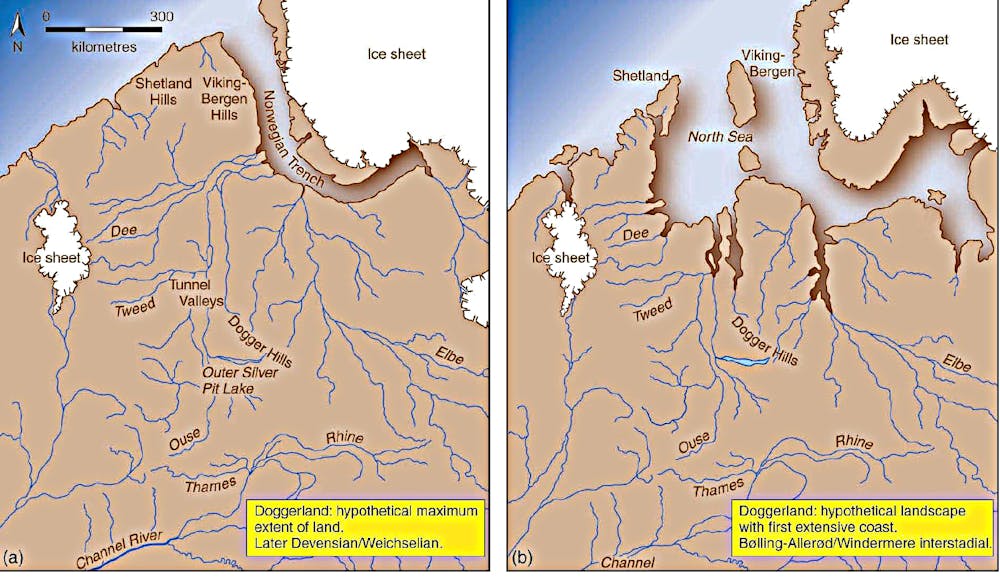
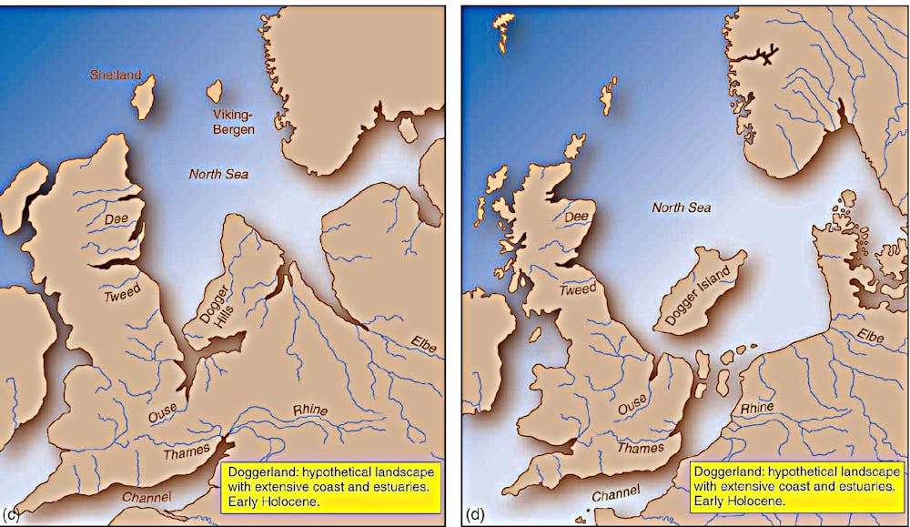
Also, we need to start seriously thinking about patches (or even a worlda sub-series) for Ice Age coastlines. For example, we only have one patch for Doggerland, but its coast changed drastically over time, as the above series of images shows.
For a good template, I'd recommend a channel called Gwillerm Kaldisti. He's got stuff on Europe, Sunda, Sahul, the Bering Strait, and even the Black + Caspian Seas.
Last edited:
Share: