The NextGen OTL Worlda Series

Made a quick little map patch:
View attachment 445612
the Five "Civilized" Tribes
(Based off of this map and the lines are dotted because I love the aesthetic)​
That's baby work. w a t c h t h i s
Native American Tribes Map.png

now every tribe's represented
Edit 9-25: If anyone wants to improve on it, you can. Just give me credit for the idea.
 
Last edited:
The general issues I have with adding (all of the) native North American tribes are:

1) While some cartographic sources exist, they generally only cover about the 1700s onwards.

2) Wing that, It’d be weird to only start showing them on the map out of the blue in 1700, as it’d appear that they only just started existing in 1700. This problem is unique to North America; we have sources for African tribal societies going back millennia.
You're right about both points, but also I did a patch for the Iroquois in 1700:
Iroquois Confederacy.png

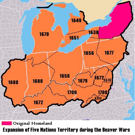
This map should also be used for the 1650, 1688, and 1700 maps:
5NationsExpansion.jpg

Edit: and this one too for 1715-1776
5NationsCession.jpg
 
Last edited:
You're right about both points, but also I did a patch for the Iroquois in 1700:
View attachment 490488
This map should also be used for the 1650 and 1688 maps:
5NationsExpansion.jpg

Edit: and this one too for 1715-1776
5NationsCession.jpg
I'm actually kind of in awe at how a country as large as the Iroquois Confederation has been entirely obliterated from existence, without any sort of successor state or geographically similar administrative division.
 
I'm actually kind of in awe at how a country as large as the Iroquois Confederation has been entirely obliterated from existence, without any sort of successor state or geographically similar administrative division.
It is quite odd, isn't it? I mean, unless you count the upstate secessionist movement, there really is no attempt at a restored Haudenausaunee confederation, even purely geographically speaking.
Actually, the State of New York used to claim a vast amount of territory in this region, and it matches up pretty well.
 
Just a quick note - I've been looking at the Rivers map...because reasons that are nothing whatsoever to do with a project that I am totally not currently working on, but some of the rivers seem to be made of disconnected pieces.

Any particular reason for this? And could they be reconnected, please?
This is because there were some lakes in those spots in the past versions of the Worlda, and when Hadaril converted them into the current worlda, those lakes were gone
 
Some questions about the 1500 map, particularly in regards to the Aztecs. Are the darker and lighter colors supposed to show the Aztec territory and its tributaries, or instead are the lighter areas supposed to be some sort of cultural sphere? Because it seems to have some issues. Here, for clarification...
1500.png

The two white areas on this map (which were colored light Aztec color)- the larger, the Purepechan Empire/lands of Tzintzuntzan, and the smaller, the Tlaxcallan state, were both independent of the Aztecs and often were at war with them. And while the Tlaxcalla were Nahua like the Aztecs, the Purepecha were both independent and not particularly culturally connected to the Aztecs either as far as I can tell

Then, with the lighter grey area on this map (which was colored regular Aztec color)... well, looking at various maps of the Aztec Empire, it looks like they just didn't exactly have any territory to the west of the Purepecha. Now, there's plenty of inexact maps on the internet and I am no expert of this era, so maybe the maps that come up with a brief look online are wrong, but this could at least warrant a second look

And then there's the darker grey area (which was colored light Aztec color) - the lands to the south, seemingly mostly Mixtec lands, a sizable part of which would seemingly be directly conquered by the Aztecs a decade or so later. This is the area which I am least sure there's actually anything wrong, but I don't know if those areas were any sort of Aztec protectorates/puppets/tributaries

Actually, I'm also not sure about the Mayans too, and how the coloring is with them and the darker vs lighter areas and what they are supposed to depict? Like, I'm pretty sure the Mayans were just a collection of city states at that point rather than any unified empire, am I wrong and the darker blue area depicts a unified state, or instead it depicts just like a broader cultural area? and then what the lighter areas depict?
 
Top