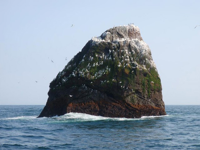
Rockall, a islet thats basically a tall rock@hadaril, quick question: on the worlda, an island appears north-west of Ireland and south of Iceland. What is this supposed to be? Is there an island there, or is it just a mistake on the map? It doesn't appear on older worlda versions (to my knowledge) and I'm not aware of any island there.
I've marked it on the cropped map below.
You are using an out of date browser. It may not display this or other websites correctly.
You should upgrade or use an alternative browser.
You should upgrade or use an alternative browser.
The NextGen OTL Worlda Series
- Thread starter hadaril
- Start date
Alex Richards
Donor
Rockall, a islet thats basically a tall rock
Huh. That one got removed in... I want to say 2016? It's not actually the rock itself that's disputed but whether the UK has exclusive control to the seabed around it, so it was decided it made more sense not to depict considering it is, after all, uninhabitable and tiny.
@hadaril, quick question: on the worlda, an island appears north-west of Ireland and south of Iceland. What is this supposed to be? Is there an island there, or is it just a mistake on the map? It doesn't appear on older worlda versions (to my knowledge) and I'm not aware of any island there.
I've marked it on the cropped map below.
View attachment 405021
Pretty sure its supposed to be Rockall
Hi! Just a handful of quibbles.
1. I helped with the 1776 map, not the nonexistent 1648 map. I'm assuming this was a copy-paste gone wrong or something.
2. I don't know why you're crediting me as "Salem" when maybe a handful of people on this site, at most, know me by my first name. Just "cultural-deleonist" is preferable.
3. I am not, and have never been a man, thanks! I've made this clear to you in particular many, many times, and I really don't appreciate you continuing to ignore that fact. Either change the "he" to "they", or remove my contributions, please.
My bad - it was a while since I last talked to you, so I tried my best to remember who it was who actually contributed the map, lmao.Hi! Just a handful of quibbles.
1. I helped with the 1776 map, not the nonexistent 1648 map. I'm assuming this was a copy-paste gone wrong or something.
2. I don't know why you're crediting me as "Salem" when maybe a handful of people on this site, at most, know me by my first name. Just "cultural-deleonist" is preferable.
3. I am not, and have never been a man, thanks! I've made this clear to you in particular many, many times, and I really don't appreciate you continuing to ignore that fact. Either change the "he" to "they", or remove my contributions, please.
Updated NCS to 4.0 (though I guess 3.6 is a better name... Hmm).
No existing colors were changed.
- Renamed Kurds to Kurds & minor Iran
- Added Tertiary Arabia
- Added Gangetic State
- Added Pandyas
- Added Minor Indian
- Added Radical Russia
- Added Conservative Russia
- Added minor Italy
- rearranged boxes
Maps haven't been updated with the additional colors as of yet. I'll update you when they are.
Hey old buddy old pal, I didn't ask you to remove the bit where you credited me entirely, especially since I did hand-draw all the North American borders on the 1776 map from next to scratch, as well as providing the edited basemap, all with the stipulation that you credited me.My bad - it was a while since I last talked to you, so I tried my best to remember who it was who actually contributed the map, lmao.

I don't want to be contrarian but...who drawn the Ancient and Medieval map? I recognize some of my work, but it seems to be completed...weirdly, to say the least (the borders, especially khaganates but not only are both oddly precise and corresponding to nothing I know). Not to sound arrogant but, frankly, they're going from inaccurate to wrong for the most part.
I can update some of what I did before to new coastline and basemap (not too soon) and I'm ready to ear about any criticism. But I honestly think it might be wise to at least label them for the time being.
I can update some of what I did before to new coastline and basemap (not too soon) and I'm ready to ear about any criticism. But I honestly think it might be wise to at least label them for the time being.
You're going to have to be a bit more specific as to what is inaccurate in the maps. I have the upmost confidence in the European maps from 800 onward; Outside of europe, I'm not as sure. I'm going to be removing the khaganates next update, as I agree they don't really work with maps like this - same goes for the germanic borders in the roman maps. If you have feedback on other areas of the world in the ancient and medieval maps, I'd love to hear it, but it needs to be specific so that I can actually address the issue.I don't want to be contrarian but...who drawn the Ancient and Medieval map? I recognize some of my work, but it seems to be completed...weirdly, to say the least (the borders, especially khaganates but not only are both oddly precise and corresponding to nothing I know). Not to sound arrogant but, frankly, they're going from inaccurate to wrong for the most part.
I can update some of what I did before to new coastline and basemap (not too soon) and I'm ready to ear about any criticism. But I honestly think it might be wise to at least label them for the time being.
Woops, my bad, I seem to have forgotten to update the post with the right version of the .txt document I keep it in! Fixing that right now!Hey old buddy old pal, I didn't ask you to remove the bit where you credited me entirely, especially since I did hand-draw all the North American borders on the 1776 map from next to scratch, as well as providing the edited basemap, all with the stipulation that you credited me.
Warning
Well, it's true that pre-800 maps are particularly problematic compared to the others, but taking the example of 1000, which seems to be based on a map I did for the same period.You're going to have to be a bit more specific as to what is inaccurate in the maps. I have the upmost confidence in the European maps from 800 onward;
Generally, the problems are that you're using overly complex and ultra detailed borders that have no real reality to be based on : it's particularly obvious in Eastern Europe and Northern Asia, as even specialized atlases as "Atlas of Central Asia" tries their best NOT to pull this sort of things. It seems pulled out of nowhere, really.
It's not just there, and can be seen in Spain too (the County of Porto northern border is arbitrary, granted, but it's why I used a simple map and not an even more arbitrary complex line without much to be supported) or Navarra.
Tiwanaku and Wari are merged for some unknown reasons, and there's a continuity of chiefdoms between peru and Panama (withut much grounds for) while Mississipian cultures (known for their high degree of development) are absent. Oh, and Asanazi's cultural area looks like...well, it doesn't looks like anything, really.
Africa is, I'm sorry to say, a disaster. I'm using sources such as UNESCO's general history of Africa and it simply doesn't fit anything. Nubia is frankly a catastrophe in itself. I shudder to think whoever drew this used as sources. And in the same time no Swalili, no proto-Zimbabwe. It's like I reverted 10 years ago when African polities weren't represented on worlda, but with worse borders.
Note that Arabia isn't much better and looks like someone just guesstimated the borders.
Central Asia and India makes literally no sense at all : I drew the map that was used as a base, and I can't figure out what's representing what. I'll pass on the disappearance of Volga Bulgars or the anachronistic depiction of Rus'
SOuth-East Asia is better, but frankly that's not a challenge : the author of the map actually, for real, used a modern Vietnamese map as base. Nanzhao was literally MOVED out of Nanzhao. It's like the problem you pointed with Czechia, only on a much, much larger and obvious scale. I agree that I badly rended Nanzhao myself, but at least it was where it's supposed to be, not going into vacation elsewhere.
Liao and Wia states are just bad, so no need to cover this too much, but you'd think that one could have figured Japan without giving up and coloring the whole island.
In fact, it's telling that whoever took my map to redo...this didn"t really felt like working and doing an actual job : years ago, I made this joke to @Alex Richards and @Lord Hastur of Carcosa that I could put a dong-shaped country on the map and nobody would be the wiser. Guess what's on the Kola peninsula in my map, and on the one in this thread? This alone makes me thinks that there was no study or research involved at all.
I'm not claiming some special knowledge or skill, but people I worked both there and outside this board on map-making know that I can take great lengths to be sure what I draw is a fair enough representation (that includes digging down to find archeological sources for ancient and medieval maps) and hunting informations. Again, I don't claim at all it makes my work unattackable or perfect (if anything I want to redo them everytime I put my eyes onto it). But I don't think the work on these was really serious : maybe some of the issues come from your choices of coloring and abandon of outlines and shades, granted, but I think the author simply didn't do his job very well on the larger scale (altough they certainly got good ideas for Amazon basin and trying to represent inner politics of Rus')
Frankly, I'd be more comfortable redoing these, it would be easier eventually.If you have feedback on other areas of the world in the ancient and medieval maps, I'd love to hear it, but it needs to be specific so that I can actually address the issue.
If you feel adamant about it, knock yourself out. I guess my work is done here.Well, it's true that pre-800 maps are particularly problematic compared to the others, but taking the example of 1000, which seems to be based on a map I did for the same period.
Frankly, I'd be more comfortable redoing these, it would be easier eventually.
Last edited:
*snip*
I feel like this came off as a bit harsh.
Last edited:
Share: