You are using an out of date browser. It may not display this or other websites correctly.
You should upgrade or use an alternative browser.
You should upgrade or use an alternative browser.
The NextGen OTL Worlda Series
- Thread starter hadaril
- Start date
Not yet. The old worlda series has it, though, if you dig deep enough.Is there a 2017 map with Chinese provinces?
I've been looking at the late-19th and early 20th century maps for reasons totally unrelated to a TL that I am totally not currently writing, and I keep seeing a country in the south of what is currently Saudi Arabia, just north of Yemen. I can't find any reference to what it is.
Can anyone explain? Is it the Banu Yam, or something to do with Najran? Is it an exiled Saudi state?
Can anyone explain? Is it the Banu Yam, or something to do with Najran? Is it an exiled Saudi state?
Not yet with this revision series, but the old series (should be on the wiki) has internal divisionsView attachment 395681 Is there by any chance a blank WorldA map with subdivisions? Something like this one but without any colored nations.
usually a paintbucket thing in paint.net, which is often used for pixel maps hereHow does one make the striped diagonal lines? Is there a tutorial somewhere for this?
Thanks, got a similar tool for PS?usually a paintbucket thing in paint.net, which is often used for pixel maps here
I've been looking at the late-19th and early 20th century maps for reasons totally unrelated to a TL that I am totally not currently writing, and I keep seeing a country in the south of what is currently Saudi Arabia, just north of Yemen. I can't find any reference to what it is.
Can anyone explain? Is it the Banu Yam, or something to do with Najran? Is it an exiled Saudi state?
I believe it is Asir
Oh! Okay. Yes. I vaguely remember when it was first being drawn. I believe it is Najran.
I think the modern US state borders in the original 13 states need to be redrawn along with some ocean borders in Georgia and the Carolinas because they are very inaccurate.
The US on the map:
 The real US:

The US on the map:
Also, the Sokoto Caliphate's a bit inaccurate? I don't really know how accurate one can make it, but I've seen most maps show this sort of shape:

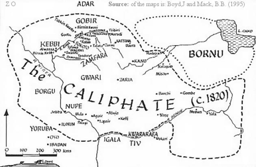

I think I unintentionally showed them in order of preciseness...
As for Borno, I found this:

I believe that map above is supposed to be around the early 1800s (1805, maybe?)
Hope you get back to the worlda mapmaking!
I think I unintentionally showed them in order of preciseness...
As for Borno, I found this:
I believe that map above is supposed to be around the early 1800s (1805, maybe?)
Hope you get back to the worlda mapmaking!
1803 & 1806 - new maps for during Napoleonic WarsView attachment 396972
A typo, it seems, in the corner of this map. You said 1803 and 1806, but both say 1803. I'm guessing the change on this one was missed.
I think the modern US state borders in the original 13 states need to be redrawn along with some ocean borders in Georgia and the Carolinas because they are very inaccurate.
The US on the map:View attachment 396699The real US:View attachment 396701
Those are two different projections. Have you adjusted "the real US" projection to map onto the projection used in the worlda maps?
Share: