The Alphabetic Bouts of Cartography: Discussion & Entries

Well, it's probably a long time (i.e. most of the next day) until I make the actual map, but just in case... :)
One of my ideas involved a map that is geographically set in and around Kenya but might well not ever feature the specific name; would that be allowed?
 
Yes, that's fine.

Also: as I might not have the time to make a proper ATL map, it might well be a map of OTL (as much as I could find out... what I wanted to picture is apparently an awfully obscure topic, so there's likely be some deviation from OTL simply because there's only so much research one could do in half a day without actually knowing anything about the topic involved). Would that be allowed?
(If not - and possibly even if yes - I could try to make a proper alternate map. I'm not sure if I could make it in time though: remember, the round ends at 7:59 Saturday morning in my time zone, so in practice I'll only have up to Friday evening - less than 24 hours left now...)
 
Also: as I might not have the time to make a proper ATL map, it might well be a map of OTL (as much as I could find out... what I wanted to picture is apparently an awfully obscure topic, so there's likely be some deviation from OTL simply because there's only so much research one could do in half a day without actually knowing anything about the topic involved). Would that be allowed?

Sure, go for it.
 
OK, it's over midnight now, and nodody else seems to do this round, so I probably would post my map (if I manage to make it).
Alas, unfortunately, while I originally estimated that by now I would be in the final stretch (if not having finished already), various personal problems meant that I'm actually barely starting, and I'm not sure I could finish in time! However, if you don't mind (and if there aren't two other entries by then), if I see that I'm unable to finish properly in time, I could post a half-finished map with whatever I missed being quickly approximated (it was going to be made in MS Paint anyway, which IIRC is supposed to be used for quick approximations). Would that be accepted, or should I rather try to finish anyway despite probably missing the deadline?
(Note: IMHO that's actually a rather unlikely scenario... my current estimates have me finishing the map within 3-4 hours, and I have over 7 hours to go. Still possible though.)
 
So what's L going to be, then? Luton? Laredo? Lakshadweep?

London? Lithuania? Leaders? Liberation? Hey, why not Land?
There are obscure topics, but there are easy ones as well. (Though IMHO this round is indeed a little too far on the obscure side... as evidenced by there still being not a single entry six hours before the deadline. :))
 
Noooh! An enterence i s in order!

ahha!.png
 
It burns! :mad::p

I didn't expect any entry to actually be so much worse than even what I would've done :eek: which means that for all serious purposes there's only one entry! Thus, I'm in, and would continue making my map (which is likely to not be serious competition to wilcoxchar's, but at least it's going to use the color in a more major way).
 
Well, my 20 seconds of Googling led to different sites than yours did, and I found that OTL they were a one-party state in this time period. The Kenya National Union Party was so popular it got 100% of the votes from 1969 through 1988. :p

I suppose a multi-party system is more likely than a two-party one for Kenya based on the witness of the years before and after.

My Wikipedia research said that Barry I's career went down the tubes in response to Tom Mboya's assasination, even though Mboya was his rival.

Another divergence from OTL is that the election happens in 1984 as scheduled. In OTL, there was an attempt at a coup in 1982. In response, the government moved the election to 1983.
 
Our POD involves greater Portugese success while Spain takes longer to unify, resulting in a weaker Habsburg empire and thus a stronger Ottoman Empire. As such, a major area of economic competition is the Indian Ocean area, with Ottoman, Portugese and Mughal trade fleets, warships and explorers plying the waves. For now (1610), the "Three Brothers of the Sea" are at peace, but this is unlikely to last too long.

Meanwhile, the Baganda Nation has become a major power in Africa: their anti-slave-trade efforts rankle Turk and Portugese alike, but they are too far inland for the Ottomans to consider sending a punitive expedition yet. A slow struggle for influence, then, across the plains of Kenya and Tanzania, is the order of the day.

IndianOceantraderoutes.png
 
Okay, amid all that competition my puny "OTL" (and really not very finished) map is unlikely to win, but hey, luck happens :)


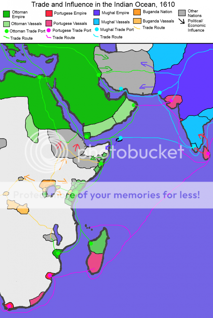
...Nowadays, when people see "Portuguese East Africa", they pretty much always think "Mozambique". Heck, even Wikipedia's article on Portuguese East Africa is named "Portuguese Mozambique".
However, while for more than half of the history of Portuguese East Africa it was indeed confined to Mozambique, that was not always the case; in the 16th and 17th centuries, it stretched north, along the coast, up into modern Tanzania and Kenya, and even (some sources say) a bit into modern Somalia (well, the country named that on the map - I won't be going any deep into the situation of modern Somalia, as it's at best tangential to this topic). Indeed, the very first Portuguese colony in East Africa was established in Malindi, in modern Kenya - during Vasco da Gama's voyage in 1498.
This all ended in the late 1690s, when the Omani army, through repeated attacks, conquered all the Portuguese colonies and outposts north of the modern Mozambique, and annexed it into the Omani sultanate of Zanzibar (named for its local capital, an island that itself was previously a Portuguese outpost).
But, as already said, Portuguese presence in this region did exist; and this map tries to list some of the major Portuguese colonies and outposts in East Africa north of Mozambique, with approximate dates when they actually were Portuguese. It might be bad-looking... but, well, maybe one day someone could do better!

OOC:
Yes, this was all made in MS Paint, excepting possibly the basemap which was taken from the wiki (unfortunately I couldn't find a basemap of larger size that contained both Malindi and Zanzibar; thus the tiny letters).
The large text on the top is Bookman Old Style; the small texts everywhere else aren't any real font, just a bunch of small letters I made up on the spot (no, seriously).
If the green area looks unexpectedly large, that's because it's based on one of the sources that included Somalia. Sorry... it was pretty much the only readable enough map of the region in the appropriate period that I was able to find online :(
And now... the actual map I made! :D

Northern Portuguese East Africa.png
 
Top