You are using an out of date browser. It may not display this or other websites correctly.
You should upgrade or use an alternative browser.
You should upgrade or use an alternative browser.
Return of Horrible Educational Maps
- Thread starter Westphalian
- Start date
I think the disqualification is more to do with there being no reason to assume it has anything to do with a school.At what point is a map so erroneous it is disqualified from this thread?
Because I have found a contender.
truthfully, i think most of the maps here have little to do with actual educational systems. a world map of Pirates of the Caribbean has been posted here more than once, for example.I think the disqualification is more to do with there being no reason to assume it has anything to do with a school.
I don't recall that. Though I do recall where someone lambasted CNN or BBC for an unrealistic map. One that was unrelated to them, had links to someone's podcast on it, and was showing details that were real, but not well known about. That, and it was made to look old. And yes, most of the maps over the last twenty pages or so haven't been about school text books so much but, alas, we are at the age where we lack access to those anyways. Such a shame. I always used to love looking through textbooks to see their maps. Kinda weird, in retrospect.truthfully, i think most of the maps here have little to do with actual educational systems. a world map of Pirates of the Caribbean has been posted here more than once, for example.
hereI don't recall that.
")
notice that each part of the ocean controlled by one of the Pirate Lords of the Brethren Court is specifically labeledView attachment 299856
Saw this on some site called "Brad Huber's Anthropology." It's.... misleading.
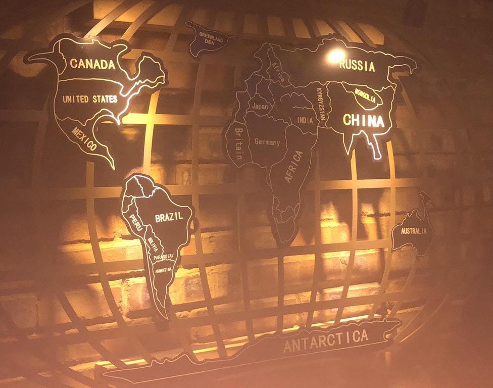
Not to mention that Kyrgyzstan has essentially become the new steppe empire, except they now have the technology to build robotic horses to counter newfangled "guns", drain the Caspian for farmland, level the Carpathians, and then flood Romania.The country's name is Greenland Den. Which I didn't think anything of, before I realized there's no Denmark.
And by my count there are 12 little countries without labels. And Paraguay's some sort of non-country, and Kyrgizstan and India seem to have an unresolved order.
I don't actually know what website it came fromWow. Did you read that on the website this map came from? I can just imagine how that would have played out.
Emperor! The enemies have invented a technology called guns! They can use them to shoot us!
Well, we can counter that by inventing robots that we can ride like horses!
At what point is a map so erroneous it is disqualified from this thread?
Because I have found a contender.
Well, it still can serve as an example of how NOT to make a world map. In that regard it is still educational.
Why is it always Interwar that people have trouble with? I think its realitively simple.
To be fair, the second map seems to be from an ATL (Peoples Republic of Poland and Italy being with the Allies are a strong hint)
Deleted member 105545
Yes, but it was labeled as Europe 1939 in a non ATL websiteTo be fair, the second map seems to be from an ATL (Peoples Republic of Poland and Italy being with the Allies are a strong hint)
The America's look just fine, though. I'm assuming, based on the Americacentrism and the overall aesthetic, that this was found in a cafe in the USA?Greenlanden. Just Greenlanden. No England, Panama or Indonesia. Africa and Japan in Europe, Germany and Britain in Africa, no india, a country called Africa in both Europe and Africa.
Which does beg the question of whether it is deliberately wrong for artsake.The America's look just fine, though. I'm assuming, based on the Americacentrism and the overall aesthetic, that this was found in a cafe in the USA?
The America's look just fine, though.
Well, aside from the US annexing most of Eastern Canada, Mexico annexing a strip to Louisiana... Poor Alaska got nuked the crap out of... Paraguay doesn't have a country and floats in nothing. There's also the Panama Strait as well.
i'd say that Australia looks best to normal, save for the odd land bridge to to Papua New Guinea... I guess old revanchist desires to retake former Australian land have resurfaced! Literally
On the plus side, no more ribbing that one Miss America contestant for talking about Africa as a country.Well, aside from the US annexing most of Eastern Canada, Mexico annexing a strip to Louisiana... Poor Alaska got nuked the crap out of... Paraguay doesn't have a country and floats in nothing. There's also the Panama Strait as well.
i'd say that Australia looks best to normal, save for the odd land bridge to to Papua New Guinea... I guess old revanchist desires to retake former Australian land have resurfaced! Literally
For shame, Business Insider, for shame...
(Featuring San Francisco in Jefferson, Dallas in Oklahoma, Indianapolis in Michigan, and Boston in Maine.)
(Featuring San Francisco in Jefferson, Dallas in Oklahoma, Indianapolis in Michigan, and Boston in Maine.)
For shame, Business Insider, for shame...
(Featuring San Francisco in Jefferson, Dallas in Oklahoma, Indianapolis in Michigan, and Boston in Maine.)
I'm sure LA is bit further south than that.
Share: