most of the errors are around poland though, other than that it's just poor color choices for some countries e.g. Scandinavian countries, Greece and BulgariaSo in my history class (9H), we're doing notes on the Treaty of Versailles.
I found one of the most inaccurate maps I think ever made. Tried looking it up, found a completely different slideshow with the same map.
This is what children have been taught that Interbellum Europe looked like:
View attachment 370508
You are using an out of date browser. It may not display this or other websites correctly.
You should upgrade or use an alternative browser.
You should upgrade or use an alternative browser.
Return of Horrible Educational Maps
- Thread starter Westphalian
- Start date
most of the errors are around poland though, other than that it's just poor color choices for some countries e.g. Scandinavian countries, Greece and Bulgaria
And the fact that Yugoslavia has Istria about thirty years too early.
And the fact that Yugoslavia has Istria about thirty years too early.
Also, those were not Greek borders in 1919; those are the post Greco-Turkish war borders.
Also, those were not Greek borders in 1919; those are the post Greco-Turkish war borders.
And that Romania doesn't have Moldova, and, for some reason, Morocco seems to be (a) united, and (b) independent.
My favorite part is independent East Prussia. And nearly flat West Prussia. And Greco-Bulgaria.So in my history class (9H), we're doing notes on the Treaty of Versailles.
I found one of the most inaccurate maps I think ever made. Tried looking it up, found a completely different slideshow with the same map.
This is what children have been taught that Interbellum Europe looked like:
View attachment 370508
And the New Kalmar Union.My favorite part is independent East Prussia. And nearly flat West Prussia. And Greco-Bulgaria.
Apart from the bad borders, I think it's part of mapmaking 101 that you don't use the same color for two different countries that border each other.
Certainly because it has been mathematicaly proven that any map can be made with 4 colors.Apart from the bad borders, I think it's part of mapmaking 101 that you don't use the same color for two different countries that border each other.
*PLANAR* maps, and that assumes no Exclaves/Enclaves. (The Enclaves/Exclaves of OTL aren't sufficient, but it is quite easy to create a such a map)Certainly because it has been mathematicaly proven that any map can be made with 4 colors.
Seen in a class on Africa. Remember the Portuguese colony of Liberia? Or what about the Hitlerite stronghold of Namibia?
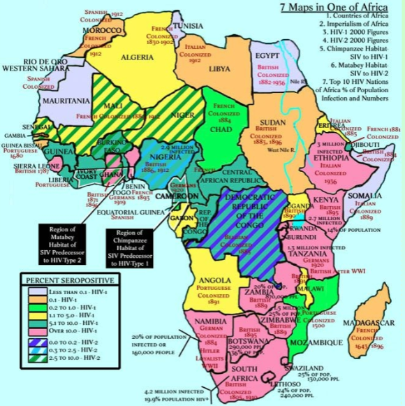
But from what I can tell there was no actual fighting there. This map seems to imply that Namibia was never taken by the British and it was heavily supportive of the Nazi Party under German rule.The German Settlers of Namibia were actually quite sympathetic to the Nazis.
I'm gonna start using these maps for inspiration for alt history, like seriously, look at that independent east Prussia
that's pretty much my opinion on these--laughably bad, but they can make for some pretty cool AH scenariosI'm gonna start using these maps for inspiration for alt history, like seriously, look at that independent east Prussia
")
Given that we recently had quite some Africa and South America maps here I guess I can put this one here as well.
A background map in an anime that features an already bad map (even with the blur one can already see stuff being quite wrong, like a Mercator projection combined with tuberculosis) which has the additional peculiar notion that the southern part of Africa is shaped like Patagonia.

A background map in an anime that features an already bad map (even with the blur one can already see stuff being quite wrong, like a Mercator projection combined with tuberculosis) which has the additional peculiar notion that the southern part of Africa is shaped like Patagonia.
Given that we recently had quite some Africa and South America maps here I guess I can put this one here as well.
A background map in an anime that features an already bad map (even with the blur one can already see stuff being quite wrong, like a Mercator projection combined with tuberculosis) which has the additional peculiar notion that the southern part of Africa is shaped like Patagonia.
View attachment 371325
Which anime is this?
Which anime is this?
From Nijuu Mensou no Musume/The Daughter of twenty Faces/Chiko, Heiress of the Phantom Thief
Lol at Sweden and India too, and where is Britain? East Asia is perfectly drawn though, to a T.Given that we recently had quite some Africa and South America maps here I guess I can put this one here as well.
A background map in an anime that features an already bad map (even with the blur one can already see stuff being quite wrong, like a Mercator projection combined with tuberculosis) which has the additional peculiar notion that the southern part of Africa is shaped like Patagonia.
View attachment 371325
Something similar to this happened in Invasion of the Neptune Men.East Asia is perfectly drawn though, to a T.
That Sinai looks awesome. Also, Mauritania was never colonized according to the map, along with Algeria and Gabon, and quite a few others. Plus, the Nile looks to be a few hundred miles wide.Seen in a class on Africa. Remember the Portuguese colony of Liberia? Or what about the Hitlerite stronghold of Namibia?
Last edited:
Share: