The best part of this is that he's using a pseuodcylindrical projection but doesn't show the borders, which is another mistake people seem to make a lot of the time.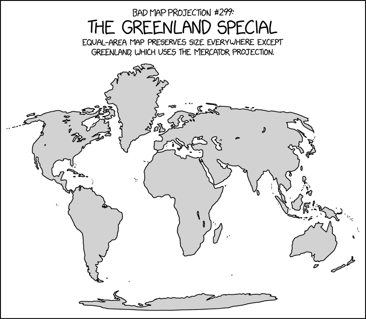
The projection for those who think the Mercator projection gives people a distorted idea of how big Greenland is, but a very accurate idea of how big it SHOULD be.
You are using an out of date browser. It may not display this or other websites correctly.
You should upgrade or use an alternative browser.
You should upgrade or use an alternative browser.
Return of Horrible Educational Maps
- Thread starter Westphalian
- Start date
Well, at least that's not something you'll find around here!The best part of this is that he's using a pseuodcylindrical projection but doesn't show the borders, which is another mistake people seem to make a lot of the time.
Er, I mean, not something you'll find around here in the years since someone added a border to that basemap.{a map chosen from among contest winners in an attempt to mitigate the perception of picking on its creator}
View attachment 96075
Ah yes, the Japanese dictator during the 30s, Japonsko Tojo.
(Also inaccurate borders, but that might as well be just Tuesday.)
Ah, but the glorious northern border of Kazakhstan is fixed, immutable, and unchanging! As it (*cocks rifle*) always has been! 
Is it just me, or has Kaliningrad Oblast already been shorn off of East Prussia, for some strange reason? Also, where did the rest of the Italian and Japanese Empire possessions disappear to?
Is it just me, or has Kaliningrad Oblast already been shorn off of East Prussia, for some strange reason? Also, where did the rest of the Italian and Japanese Empire possessions disappear to?
Crazy Boris
Banned

I'm taking a Swedish class and today I had this exercise, I had to select the official languages of various countries
someone needs to tell my teacher that Napoleon lost.
I dunno if im allowed to actually post this or if I'll get expelled for it or something, but it'll be worth it to share this little Rheinbund cameo.
Well... I rather like the... anachronism
I'm taking a Swedish class and today I had this exercise, I had to select the official languages of various countries
someone needs to tell my teacher that Napoleon lost.
I dunno if im allowed to actually post this or if I'll get expelled for it or something, but it'll be worth it to share this little Rheinbund cameo.
of this! Was this a live class or online? I would've loved to look around and see how many of my classmates were scratching their heads at this one
If I had taken up teaching, this looks like something I would do just to see who was still paying attention
Crazy Boris
Banned
The class itself is live but the assignments are all onlineWell... I rather like the... anachronism
Was this a live class or online? I would've loved to look around and see how many of my classmates were scratching their heads at this one
If I had taken up teaching, this looks like something I would do just to see who was still paying attention
And Niger has been renamed Nigeria and decided to speak English instead of French.So the Russians bought Alaska back and Singapore annexed parts of Malaysia?
Also why Nigeria and no other former non-Anglo colonies? Are there really that much more people who speak English as a first language in Nigeria than in other former colonies?
I made an timeline about this without Nile Perch introduction.MISSING: Lake Victoria
Last seen: Boise, Idaho; July 28 2021
Reward: approximately 500 species of cichlids
If found, please contact Uganda at 1-800-IDIAMIN
man growing up indian american in the 80s and 90s was so fricking coolWe should create a thread for bad maps, that said, here is one particularly offending map I found.

Crazy Boris
Banned
Ah yes, when Poland and Germany drained the Baltic and partitioned FennoscandiaAt first I thought not too bad given that it is obviously hand-drawn and maybe made by children.
Then I looked at Europe...
View attachment 690100
Ah yes, when Poland and Germany drained the Baltic and partitioned Fennoscandia
Actually if you look closer Fennoscandia is still north of Germany and Poland, they've just been painted over. Not that this makes the map any better...
From Burning at Europe's Borders. Not the worst map in the world but a few inaccuracies:
1. Spanish Mauritania
2. French Western Sahara
2. “After” Berlin Conference whereas the map is more roughly 1917
3. Unchanging Libyan borders
4. Weird borders between colonies that reflect modern national borders
5. “GERMEN”
Clearly the author made this map in less than an hour on photoshop and could've devoted an extra 10 minutes to making sure what she was making was accurate.

Edit: lol this is the first Google result and the author just quickly copied it: https://www.google.com/search?q=con...iw=1422&bih=720&dpr=1.35#imgrc=Z8GI-8NNWol3_M
Edit 2: why is this map everywhere https://www.msn.com/en-gb/news/worl...-claim-about-african-colonies-map/ar-BB1flFVm
1. Spanish Mauritania
2. French Western Sahara
2. “After” Berlin Conference whereas the map is more roughly 1917
3. Unchanging Libyan borders
4. Weird borders between colonies that reflect modern national borders
5. “GERMEN”
Clearly the author made this map in less than an hour on photoshop and could've devoted an extra 10 minutes to making sure what she was making was accurate.
Edit: lol this is the first Google result and the author just quickly copied it: https://www.google.com/search?q=con...iw=1422&bih=720&dpr=1.35#imgrc=Z8GI-8NNWol3_M
Edit 2: why is this map everywhere https://www.msn.com/en-gb/news/worl...-claim-about-african-colonies-map/ar-BB1flFVm
Last edited:
Edit 2: why is this map everywhere https://www.msn.com/en-gb/news/worl...-claim-about-african-colonies-map/ar-BB1flFVm
Speaking of maps being everywhere that one specific basemap has struck again, this time apparently near a GRE Diagnostic Test (found on reddit)
My inner aficionado of map projections cries....Speaking of maps being everywhere that one specific basemap has struck again, this time apparently near a GRE Diagnostic Test (found on reddit)
View attachment 691447
Crazy Boris
Banned
Speaking of maps being everywhere that one specific basemap has struck again, this time apparently near a GRE Diagnostic Test (found on reddit)
View attachment 691447
Nations of the world:
-United States
-Canada
-Other
Also, don’t look at Siberia, worst mistake of my life
Share: