My last request for the foreseeable future: I humbly request a flag of the United States of America with the following parameters:

*png format

*A size of 1,280 x 674 pixels

*A total of 76 stars that follows proper arrangement formulas (in other words, please just don't try to cram 76 stars into the canton randomly)

*Colors shall be these (RGB values):
1)Red = (179, 29, 49)
2)White = (255, 255, 255)
3)Blue = (57, 56, 110)

tl;dr: I request this US flag, but with 76 stars instead of 50: https://upload.wikimedia.org/wikipe....svg/1280px-Flag_of_the_United_States.svg.png

Many thanks to whoever picks this up.

 
My last request for the foreseeable future: I humbly request a flag of the United States of America with the following parameters:
1677217155711.png

From The N States of America (76 states, "short" pattern), edited by me.
 
View attachment 813077
Could someone make a COA for this flag?
How about this?
Blu_red_chevron_wht_star_wht-for_lionjedi1215-FG.png (click the thumbnail for the full-size image)
The blazon is: Parted per chevron azure and gules, a chevron argent, in chief a star of five points argent.
Image created by FriendlyGhost using paint.net, based on an image posted by lionjedi1215 here.
This image is licensed under the CC BY-NC-SA 4.0 licence (see details below). You are free to use it, including adaptation, for non-commercial use, as long as you give attribution.
Attribution:
On this site (alternatehistory.com), just @ my username.
On other sites, link to my profile page here, where a message would also be nice, so I can see where my images are used.
Licence details:
Creative Commons
CC BY-NC-SA 4.0: Attribution-Noncommercial-Share Alike 4.0
Details of applicability/compatibility of each licence
 
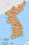
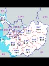
Can someone draw a border of the proposed Korean provinces of North and South Gyeonggi-do?
 

Attachments

  • 1678125256533.jpg
    1678125256533.jpg
    1.8 MB · Views: 86
  • Screenshot_20230306_131543_Gallery.jpg
    Screenshot_20230306_131543_Gallery.jpg
    538.3 KB · Views: 74
  • Screenshot_20230306_131547_Gallery.jpg
    Screenshot_20230306_131547_Gallery.jpg
    682.5 KB · Views: 84
This could be a simple one: Dragon Warrior III has this neat overworld map based on the real world, with the exception being the giant continent between little Australia and the Americas.

image.jpeg


If you were to "un-morph" that continent back to something that would fit in the real Earth (in the same way that the fantasy continents of this setting are morphed versions of our world), what would Aliahan look like?

Here's a fan recreation for reference:

image.gif
 
Not a map request, just seeking advice.

If I've got a rough sketch of a physical map, and want to give a 3D-esque impression of hill and mountain formations, is there some way I could, for example, select the coloured area I've assigned to hills and bend/warp said terrain in such a way I'd get a 3D-esque undulating effect, like in some Wikipedia maps? Or any other similar trick.
 
Last edited:
This could be a simple one: Dragon Warrior III has this neat overworld map based on the real world, with the exception being the giant continent between little Australia and the Americas.

View attachment 818891

If you were to "un-morph" that continent back to something that would fit in the real Earth (in the same way that the fantasy continents of this setting are morphed versions of our world), what would Aliahan look like?

Here's a fan recreation for reference:

View attachment 818892
You're looking for the infamous lost continent of "Mu".
 
Not a map request, just seeking advice.

If I've got a rough sketch of a physical map, and want to give a 3D-esque impression of hill and mountain formations, is there some way I could, for example, select the coloured area I've assigned to hills and bend/warp said terrain in such a way I'd get a 3D-esque undulating effect, like in some Wikipedia maps? Or any other similar trick.

I forgot, this is an example of the kinda effect I'm after:

https://upload.wikimedia.org/wikipe...svg/1024px-Andorra_topographic_map-en.svg.png
 
That's different shades of colour for different heights, combined with a bit of map shading (simulating the light coming from the top-left of the pic, which is best for perception, apparently). Here's a couple of sites which might be of some help - one focussed on real-world maps, the other on fantasy:
 
That's different shades of colour for different heights, combined with a bit of map shading (simulating the light coming from the top-left of the pic, which is best for perception, apparently). Here's a couple of sites which might be of some help - one focussed on real-world maps, the other on fantasy:
Thanks, I will check those out. :)
 
Top