a Sun In Splendor. What about the chain around the shield ? What order is that meant to be ?

I'm quite sure I saw the sheep/fleece of the Order of Golden Fleece but there was another order outside of it, which I'm not sure about.

I'm pretty sure I see lions and castles in the chain, so one should check the orders of Spain/Castile-Leon.
 
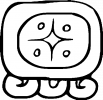
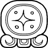
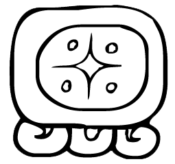
Can someone adjust the pixels of this glyph (Q'anil) to 495 without compromising its quality? Thanks:
8-qanil.png
 
Could someone make a map for me with the following borders in the Americas:

  • Canada as OTL but also including Alaska, Greenland, Maine, Vermont, New Hampshire, Michigan, Washington State, Oregon, Idaho and a southern border west of the Great Lakes corresponding to the original borders of the Louisiana Purchase.
  • USA minus the above but including the whole of Mexico and Central America (aside from Belize) Puerto Rico, Cuba, and the island of Hispaniola.
  • Gran Colombia including OTL Colombia, Venezuela and Ecuador.
  • Brazil as per OTL
  • Suriname as per OTL.
  • French Guiana as per OTL
  • A West Indies Federation including Guyana, Belize and current/ex-British colonies in the Caribbean
  • Peru including OTL Bolivia and Peru and Paraguay
  • Argentina including OTL Chile and Uruguay.
 

Deleted member 108228

Could someone make a Titan WorldA, but in the style of these?


90
 
Last edited by a moderator:
Not sure if this is the right thread, but anyone has a map of the subdivisions of Portuguese Guinea and Spanish Guinea? in preference ones from the 1960s shortly before their independence, would they be more or less like what Guiné-Bissau and Equatorial Guinea are today?


In Metropolitan Portugal, Angola, Mozambique and Portuguese India, the largest territorial divisions were districts, these were further divided into concelhos (municipal councils) in Metropolitan Portugal and Cape Verde, São Tomé and Príncipe, Portuguese India and Macau. In Portuguese Guinea, Angola, Mozambique and Portuguese Timor the districts were divided into concelhos only if there was some sort of town or city with a larger "civilised population". The more rural/native areas were circunscrições (circumscriptions; singular: circunscricão). The conselho had at its head an elected mayor, whereas the circunscricão was administered by a chefe de posto or administrator appointed by the overseas ministry.

Portuguese Guinea in 1974 was divided into 12 divisions with Bafatá, Bissau, and Bolama all being conselhos. The other 9 were circunscrições, these were: Bijagós (capital Bubaque), Bissorã, Cacheu (Teixeira Pinto), Catió, Farim, Fulacunda, Gabú (Nova Lamego), Mansôa and São Domingos. Unless specified, the administrative centre corresponds to the name of the division.

After independence the old divisions became regions. In 1976 the name of Catió was changed to Tombali, and the eastern part of Fulacunda was annexed to it. The remainder of Fulacunda was renamed Buba, and its capital moved from Fulacunda to Buba. São Domingos and the western part of Farim were annexed to Cacheu. Oio formed by merging Bissorã, Mansôa, and the remainder of Farim. Bijagós merged with Bolama. In 1990 Bissau region was split into Bissau and Biombo. Also, the name of Buba region was changed to Quinara.
 
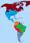
Could someone make a map for me with the following borders in the Americas:

  • Canada as OTL but also including Alaska, Greenland, Maine, Vermont, New Hampshire, Michigan, Washington State, Oregon, Idaho and a southern border west of the Great Lakes corresponding to the original borders of the Louisiana Purchase.
  • USA minus the above but including the whole of Mexico and Central America (aside from Belize) Puerto Rico, Cuba, and the island of Hispaniola.
  • Gran Colombia including OTL Colombia, Venezuela and Ecuador.
  • Brazil as per OTL
  • Suriname as per OTL.
  • French Guiana as per OTL
  • A West Indies Federation including Guyana, Belize and current/ex-British colonies in the Caribbean
  • Peru including OTL Bolivia and Peru and Paraguay
  • Argentina including OTL Chile and Uruguay.
Something like this? I think I followed the instructions but the US-Canada border looks a bit wonky...
 

Attachments

  • AH Map America's.png
    AH Map America's.png
    456.1 KB · Views: 212
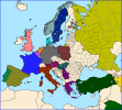
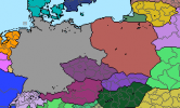
Could someone make a Qbam map where the territories marked as A and B (basically the two darkest ones) are the German Polish borders?

1636786698575.png


Also could someone do that but for this map format (I don't know the name)
1636786861331.png
 
Some Fallout-base ideas for flags if someone would be so kindly.

An Republic of Vegas flag. My idea is the OTL Nevada/Las Vegas flag as a base, with Hoover Dam in the upper left hand corner, with Battle Born below it and a star above it. An reddish Mojave stripe/bar color to represent the soil, rocks, and the blood shed to match the gray one.

An second is a flag for a Van Der Linde gang that was ISOT in and became an PMC following Dutch's death. An sorta burnt red/orange backdrop with an revolver and rifle overlapping each other in the middle. With the words VDL and year of founding 2283 under it.
 
Hey could someone make a version of this map with subdivisions?
2395px-Europe_laea_location_map.svg.png

It's from wikipedia and made with programs that have them i think so it shouldn't be too hard
 
Last edited:
Hello, I am hoping someone might be up for creating a flag for Tyrrhenia, a constitutional monarchy made up of Sicily, Sardinia, and Corsica. The idea I had in mind is that they would be one of the kingdoms in a British Imperial Federation in the mid to late-1800s. The kingdom was created by the confederation of a number of British protectorates and remains in the federation due to looming concerns about France. They are eventually granted administrative suzerainty over Malta and Gibraltar once it becomes clear that they are committed to the Federation. This would possibly include the Balearics as well Ceuta and Melilla following a war with Spain.
I would be interested in seeing alternatives as well
The simplest would be a British ensign, white or red, with a symbol representative of Tyrrhenia. Perhaps the 3 traditional arms combined.
 
Top